Temalacayuca elevation
Temalacayuca (Puebla, Tepanco de López), Mexico elevation is 1901 meters and Temalacayuca elevation in feet is 6237 ft above sea level [src 1]. Temalacayuca is a populated place (feature code) with elevation that is 587 meters (1926 ft) bigger than average city elevation in Mexico.
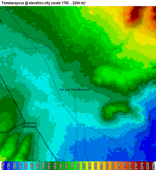
Below is the Elevation map of Temalacayuca, which displays elevation range with different colors. Scale of the first map is from 1762 to 2254 m (5781 to 7395 ft) with average elevation of 1911.1 meters (=6270 ft) [note 1]
These maps also provides idea of topography and contour of this city, they are displayed at different zoom levels. More info about maps, scale and edge coordinates you can find below images.
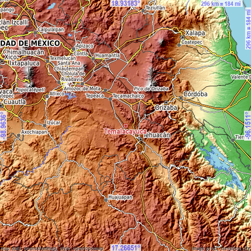
| \ | Map #1 | Topo.Map |
| Scale [m] | 1762..2254 m | × |
| Scale [ft] | 5781..7395 ft | × |
| Average | 1911.1 m = 6270 ft | × |
| Width | 9.26 km = 5.8 mi | 296.4 km = 184.2 mi |
| Height | 9.26 km = 5.8 mi | 296.4 km = 184.2 mi |
| ↑Max Latitude | 18.646034° | 19.93183° |
| Latitude at center | 18.60439° | 18.60439° |
| ↓Min Latitude | 18.562736° | 17.26651° |
| ← Min Longitude | -97.601295° | -98.9636° |
| Longitude center | -97.55735° | -97.55735° |
| →Max Longitude | -97.513405° | -96.1511° |
Nearby cities:
Cities around Temalacayuca sort by population:
• Miahuatlán elevation 1784 m
13.8 km,  116°
116°
• San Marcos Tlacoyalco 1966 m
9.1 km,  327°
327°
• Magdalena Cuayucatepec 1741 m
9.8 km,  128°
128°
• Tlacotepec 1944 m
13.5 km,  309°
309°
• Santa María la Alta 1961 m
10.6 km,  267°
267°
• Teontepec 1817 m
12.8 km,  166°
166°
• San Andrés Cacaloapan 1892 m
3.9 km,  233°
233°
• Tepanco 1816 m
5.3 km,  184°
184°
• San José Buenavista 1988 m
6.5 km,  339°
339°
• Pericotepec 1909 m
7.8 km, 271°
• San Martín Esperilla 2437 m
14.3 km,  4°
4°
• San José Tlacuitlapan 2015 m
13.5 km, 328°
Multilingual:
 En español:
Temalacayuca elevación 1901 m.
 En France:
Temalacayuca élévation 1901 m.
 Auf Deutsch:
Temalacayuca höhe über dem Meeresspiegel ist 1901 m.

Sources and notes:
- [note 1] Map square and city borders are not equal. Map elevation data is calculated only from area inside that square.
- [src 1] Elevation data from geonames database provided with same terms of usage.
- [src 2] The elevation map of Temalacayuca is generated using elevation data from NASA's 3 arcsec (90m) resolution SRTM data.
- [src 3] Base (background) map © OpenStreetMap contributors tiles are generated by Geofabrik and OpenTopoMap.
Copyright & License:
This Temalacayuca Elevation Map is licensed under CC BY-SA. You may reuse any part from this page, if you give a proper credit by linking to this URL:
 More info on terms of use page.