San Marcos Tlacoyalco elevation
San Marcos Tlacoyalco (Puebla, Tlacotepec de Benito Juárez), Mexico elevation is 1966 meters and San Marcos Tlacoyalco elevation in feet is 6450 ft above sea level [src 1]. San Marcos Tlacoyalco is a populated place (feature code) with elevation that is 652 meters (2139 ft) bigger than average city elevation in Mexico.
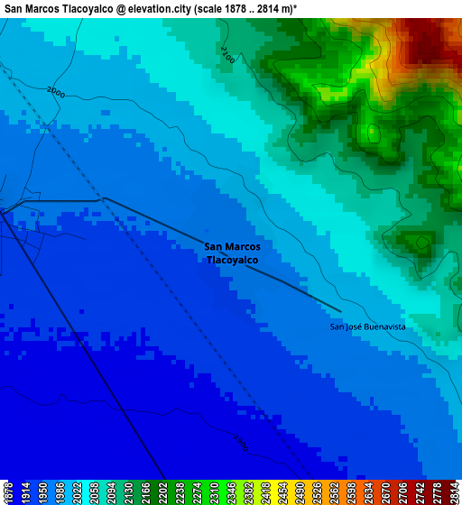
Below is the Elevation map of San Marcos Tlacoyalco, which displays elevation range with different colors. Scale of the first map is from 1878 to 2814 m (6161 to 9232 ft) with average elevation of 2019 meters (=6624 ft) [note 1]
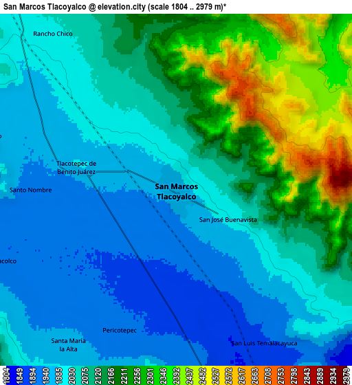
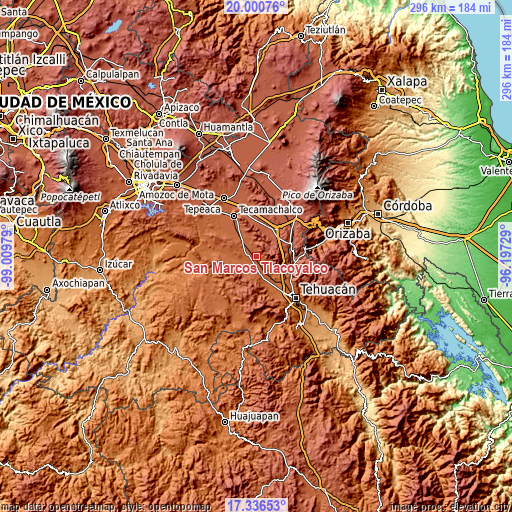
These maps also provides idea of topography and contour of this city, they are displayed at different zoom levels. More info about maps, scale and edge coordinates you can find below images.
| \ | Map #1 | Map #2 | Topo.Map |
| Scale [m] | 1878..2814 m | 1804..2979 m | × |
| Scale [ft] | 6161..9232 ft | 5919..9774 ft | × |
| Average | 2019 m = 6624 ft | 2085.9 m = 6844 ft | × |
| Width | 9.26 km = 5.8 mi | 18.52 km = 11.5 mi | 296.2 km = 184 mi |
| Height | 9.26 km = 5.8 mi | 18.52 km = 11.5 mi | 296.3 km = 184.1 mi |
| ↑Max Latitude | 18.715507° | 18.757123° | 20.00076° |
| Latitude at center | 18.67388° | 18.67388° | 18.67388° |
| ↓Min Latitude | 18.632243° | 18.590596° | 17.33653° |
| ← Min Longitude | -97.647485° | -97.691431° | -99.00979° |
| Longitude center | -97.60354° | -97.60354° | -97.60354° |
| →Max Longitude | -97.559595° | -97.515649° | -96.19729° |
Nearby cities:
Cities around San Marcos Tlacoyalco sort by population:
• Tlacotepec elevation 1944 m
5.6 km,  279°
279°
• Santa María la Alta 1961 m
10 km,  214°
214°
• San Andrés Cacaloapan 1892 m
10.2 km,  170°
170°
• Santo Nombre 1926 m
7.6 km,  270°
270°
• Temalacayuca 1901 m
9.1 km,  147°
147°
• San José Buenavista 1988 m
3 km,  121°
121°
• Rancho Chico 2016 m
10.4 km,  321°
321°
• Tepazolco 1971 m
10.2 km,  286°
286°
• Pericotepec 1909 m
8 km,  201°
201°
• Tepetlacolco 1911 m
10.1 km,  248°
248°
• San Martín Esperilla 2437 m
8.8 km,  42°
42°
• San José Tlacuitlapan 2015 m
4.4 km,  328°
328°
Multilingual:
 En español:
San Marcos Tlacoyalco elevación 1966 m.
 En France:
San Marcos Tlacoyalco élévation 1966 m.
 Auf Deutsch:
San Marcos Tlacoyalco höhe über dem Meeresspiegel ist 1966 m.
 На русском:
San Marcos Tlacoyalco высота над уровнем моря 1966 м
Sources and notes:
- [note 1] Map square and city borders are not equal. Map elevation data is calculated only from area inside that square.
- [src 1] Elevation data from geonames database provided with same terms of usage.
- [src 2] The elevation map of San Marcos Tlacoyalco is generated using elevation data from NASA's 3 arcsec (90m) resolution SRTM data.
- [src 3] Base (background) map © OpenStreetMap contributors tiles are generated by Geofabrik and OpenTopoMap.
Copyright & License:
This San Marcos Tlacoyalco Elevation Map is licensed under CC BY-SA. You may reuse any part from this page, if you give a proper credit by linking to this URL:
 More info on terms of use page.