Tehuacán elevation
Tehuacán (Puebla), Mexico elevation is 1643 meters and Tehuacán elevation in feet is 5390 ft above sea level [src 1]. Tehuacán is a seat of a second-order administrative division (feature code) with elevation that is 329 meters (1079 ft) bigger than average city elevation in Mexico.
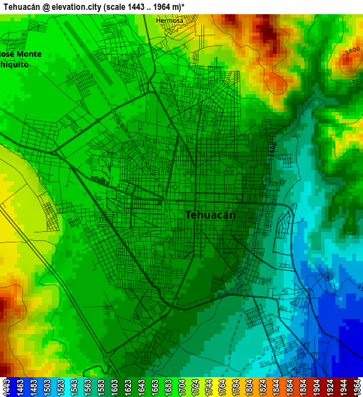
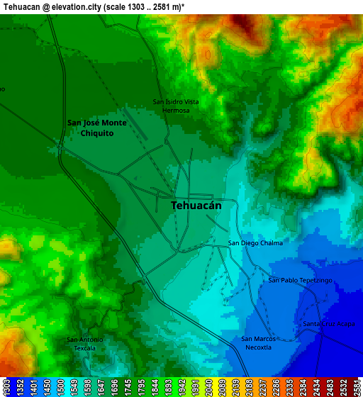
Below is the Elevation map of Tehuacán, which displays elevation range with different colors. Scale of the first map is from 1443 to 1964 m (4734 to 6444 ft) with average elevation of 1650.5 meters (=5415 ft) [note 1]
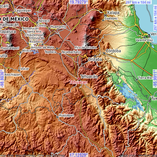
These maps also provides idea of topography and contour of this city, they are displayed at different zoom levels. More info about maps, scale and edge coordinates you can find below images.
| \ | Map #1 | Map #2 | Topo.Map |
| Scale [m] | 1443..1964 m | 1303..2581 m | × |
| Scale [ft] | 4734..6444 ft | 4275..8468 ft | × |
| Average | 1650.5 m = 5415 ft | 1722.1 m = 5650 ft | × |
| Width | 9.27 km = 5.8 mi | 18.54 km = 11.5 mi | 296.6 km = 184.3 mi |
| Height | 9.27 km = 5.8 mi | 18.54 km = 11.5 mi | 296.6 km = 184.3 mi |
| ↑Max Latitude | 18.505898° | 18.547566° | 19.79279° |
| Latitude at center | 18.46422° | 18.46422° | 18.46422° |
| ↓Min Latitude | 18.422532° | 18.380834° | 17.12529° |
| ← Min Longitude | -97.441295° | -97.485241° | -98.8036° |
| Longitude center | -97.39735° | -97.39735° | -97.39735° |
| →Max Longitude | -97.353405° | -97.309459° | -95.9911° |
Nearby cities:
Cities around Tehuacán sort by population:
• Miahuatlán elevation 1784 m
10.5 km,  334°
334°
• Magdalena Cuayucatepec 1741 m
13.2 km,  315°
315°
• Teontepec 1817 m
14.3 km,  282°
282°
• San Isidro Vista Hermosa 1754 m
4.6 km,  356°
356°
• Necoxtla 1430 m
8.3 km,  151°
151°
• San Antonio Cañada 1855 m
12.3 km,  62°
62°
• San José Monte Chiquito 1690 m
5.6 km,  309°
309°
• Tepetzingo 1401 m
7.8 km,  126°
126°
• Francisco Ignacio Madero 1705 m
7.7 km,  294°
294°
• Santa Cruz Acapa 1345 m
10 km, 130°
• Necoxcalco 1530 m
10.5 km,  92°
92°
• Texcala 1686 m
9 km,  214°
214°
Multilingual:
 En español:
Tehuacán elevación 1643 m.
 En France:
Tehuacán élévation 1643 m.
 Auf Deutsch:
Tehuacán höhe über dem Meeresspiegel ist 1643 m.

Sources and notes:
- [note 1] Map square and city borders are not equal. Map elevation data is calculated only from area inside that square.
- [src 1] Elevation data from geonames database provided with same terms of usage.
- [src 2] The elevation map of Tehuacán is generated using elevation data from NASA's 3 arcsec (90m) resolution SRTM data.
- [src 3] Base (background) map © OpenStreetMap contributors tiles are generated by Geofabrik and OpenTopoMap.
Copyright & License:
This Tehuacán Elevation Map is licensed under CC BY-SA. You may reuse any part from this page, if you give a proper credit by linking to this URL:
 More info on terms of use page.