Palmar de Bravo elevation
Palmar de Bravo (Puebla), Mexico elevation is 2199 meters and Palmar de Bravo elevation in feet is 7215 ft above sea level [src 1]. Palmar de Bravo is a seat of a second-order administrative division (feature code) with elevation that is 885 meters (2904 ft) bigger than average city elevation in Mexico.
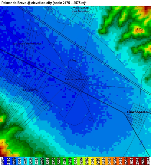
Below is the Elevation map of Palmar de Bravo, which displays elevation range with different colors. Scale of the first map is from 2175 to 2575 m (7136 to 8448 ft) with average elevation of 2232 meters (=7323 ft) [note 1]
These maps also provides idea of topography and contour of this city, they are displayed at different zoom levels. More info about maps, scale and edge coordinates you can find below images.
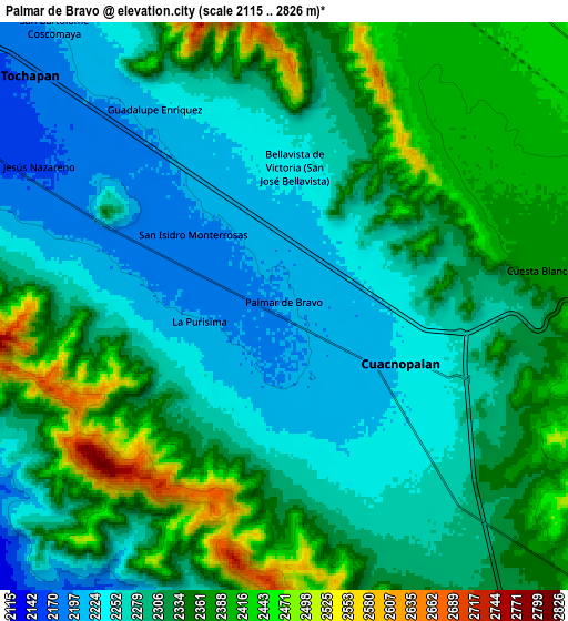
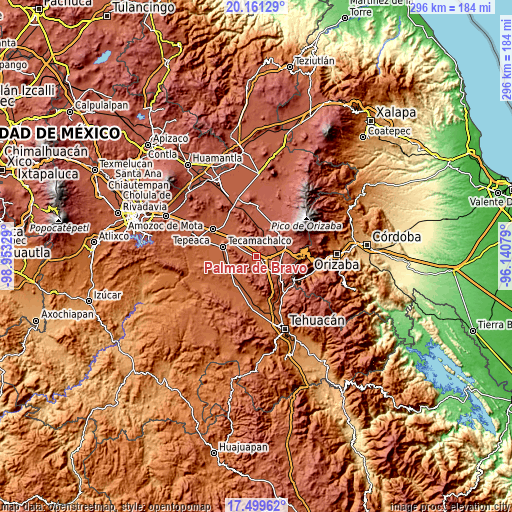
| \ | Map #1 | Map #2 | Topo.Map |
| Scale [m] | 2175..2575 m | 2115..2826 m | × |
| Scale [ft] | 7136..8448 ft | 6939..9272 ft | × |
| Average | 2232 m = 7323 ft | 2313.2 m = 7589 ft | × |
| Width | 9.25 km = 5.7 mi | 18.5 km = 11.5 mi | 295.9 km = 183.9 mi |
| Height | 9.25 km = 5.7 mi | 18.5 km = 11.5 mi | 296 km = 183.9 mi |
| ↑Max Latitude | 18.877317° | 18.918893° | 20.16129° |
| Latitude at center | 18.83573° | 18.83573° | 18.83573° |
| ↓Min Latitude | 18.794133° | 18.752526° | 17.49962° |
| ← Min Longitude | -97.590985° | -97.634931° | -98.95329° |
| Longitude center | -97.54704° | -97.54704° | -97.54704° |
| →Max Longitude | -97.503095° | -97.459149° | -96.14079° |
Nearby cities:
Cities around Palmar de Bravo sort by population:
• Palmarito Tochapan elevation 2157 m
12.1 km,  307°
307°
• Xaltepec 2176 m
8.2 km, 308°
• Cuacnopalan 2227 m
4.3 km,  118°
118°
• Cuesta Blanca 2370 m
8.4 km,  82°
82°
• La Purísima 2203 m
2.8 km,  256°
256°
• Jesús Nazareno 2169 m
9.2 km,  299°
299°
• Bellavista de Victoria (San José Bellavista) 2239 m
4.5 km,  4°
4°
• Guadalupe Enríquez 2218 m
7.7 km,  326°
326°
• San Bartolomé 2202 m
11.9 km,  320°
320°
• San Isidro Monterrosas 2193 m
3.8 km, 308°
• San Pedro Temamatla 2419 m
10.6 km,  20°
20°
• San Martín Esperilla 2437 m
11.5 km,  180°
180°
Multilingual:
 En español:
San Agustín del Palmar elevación 2199 m.
 En France:
Palmar de Bravo élévation 2199 m.
 Auf Deutsch:
Palmar de Bravo höhe über dem Meeresspiegel ist 2199 m.

Sources and notes:
- [note 1] Map square and city borders are not equal. Map elevation data is calculated only from area inside that square.
- [src 1] Elevation data from geonames database provided with same terms of usage.
- [src 2] The elevation map of Palmar de Bravo is generated using elevation data from NASA's 3 arcsec (90m) resolution SRTM data.
- [src 3] Base (background) map © OpenStreetMap contributors tiles are generated by Geofabrik and OpenTopoMap.
Copyright & License:
This Palmar de Bravo Elevation Map is licensed under CC BY-SA. You may reuse any part from this page, if you give a proper credit by linking to this URL:
 More info on terms of use page.