Galiākot elevation
Galiākot (Rajasthan, Dūngarpur), India elevation is 136 meters and Galiākot elevation in feet is 446 ft above sea level [src 1]. Galiākot is a populated place (feature code) with elevation that is 157 meters (515 ft) smaller than average city elevation in India.
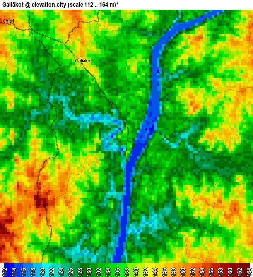
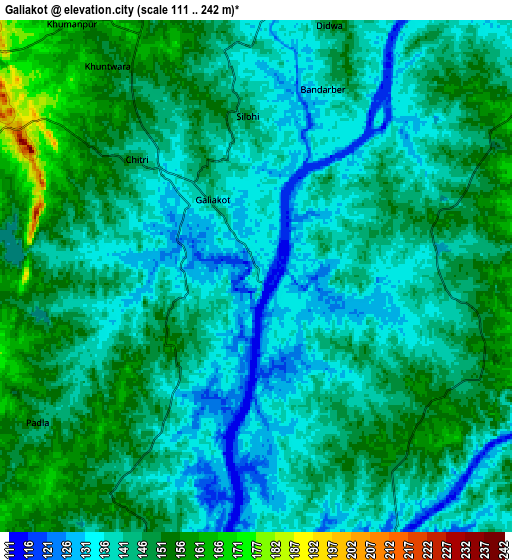
Below is the Elevation map of Galiākot, which displays elevation range with different colors. Scale of the first map is from 112 to 164 m (367 to 538 ft) with average elevation of 135.1 meters (=443 ft) [note 1]
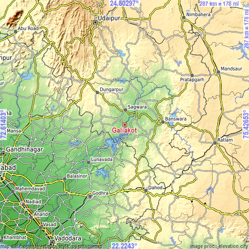
These maps also provides idea of topography and contour of this city, they are displayed at different zoom levels. More info about maps, scale and edge coordinates you can find below images.
| \ | Map #1 | Map #2 | Topo.Map |
| Scale [m] | 112..164 m | 111..242 m | × |
| Scale [ft] | 367..538 ft | 364..794 ft | × |
| Average | 135.1 m = 443 ft | 144.1 m = 473 ft | × |
| Width | 8.96 km = 5.6 mi | 17.92 km = 11.1 mi | 286.7 km = 178.1 mi |
| Height | 8.96 km = 5.6 mi | 17.92 km = 11.1 mi | 286.7 km = 178.1 mi |
| ↑Max Latitude | 23.560238° | 23.600514° | 24.80297° |
| Latitude at center | 23.51995° | 23.51995° | 23.51995° |
| ↓Min Latitude | 23.479649° | 23.439337° | 22.2243° |
| ← Min Longitude | 73.976335° | 73.932389° | 72.61403° |
| Longitude center | 74.02028° | 74.02028° | 74.02028° |
| →Max Longitude | 74.064225° | 74.108171° | 75.42653° |
Nearby cities:
Cities around Galiākot sort by population:
• Bānswāra elevation 227 m
43.1 km,  86°
86°
• Dohad 310 m
80.2 km,  162°
162°
• Modāsa 147 m
73.9 km,  265°
265°
• Dūngarpur 292 m
47.5 km,  319°
319°
• Lūnāvāda 104 m
60.4 km,  223°
223°
• Morwa 159 m
70.9 km,  195°
195°
• Sālūmbar 242 m
68.5 km,  2°
2°
• Meghraj 168 m
51.7 km, 267°
• Kushālgarh 293 m
56.6 km,  129°
129°
• Partāpur 155 m
17.6 km,  62°
62°
• Virpur 107 m
66.3 km,  236°
236°
• Mālpur 145 m
59.3 km,  252°
252°
Multilingual:
 En español:
Galiākot elevación 136 m.
 En France:
Galiākot élévation 136 m.
 Auf Deutsch:
Galiākot höhe über dem Meeresspiegel ist 136 m.

Sources and notes:
- [note 1] Map square and city borders are not equal. Map elevation data is calculated only from area inside that square.
- [src 1] Elevation data from geonames database provided with same terms of usage.
- [src 2] The elevation map of Galiākot is generated using elevation data from NASA's 3 arcsec (90m) resolution SRTM data.
- [src 3] Base (background) map © OpenStreetMap contributors tiles are generated by Geofabrik and OpenTopoMap.
Copyright & License:
This Galiākot Elevation Map is licensed under CC BY-SA. You may reuse any part from this page, if you give a proper credit by linking to this URL:
 More info on terms of use page.