Dohad elevation
Dohad (Gujarat), India elevation is 310 meters and Dohad elevation in feet is 1017 ft above sea level [src 1]. Dohad is a populated place (feature code) with elevation that is 17 meters (56 ft) bigger than average city elevation in India.
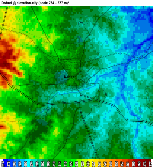
Below is the Elevation map of Dohad, which displays elevation range with different colors. Scale of the first map is from 274 to 377 m (899 to 1237 ft) with average elevation of 307.9 meters (=1010 ft) [note 1]
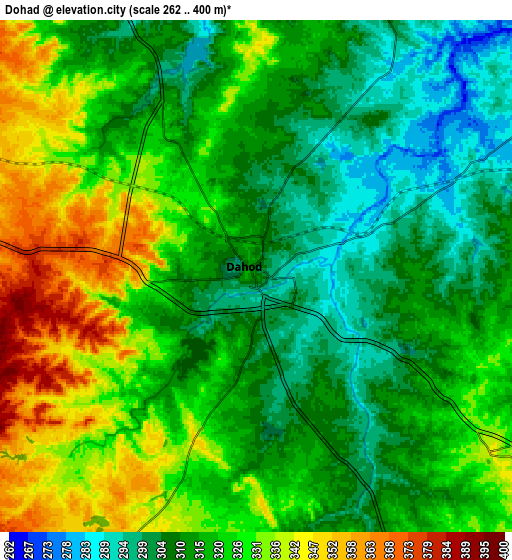
These maps also provides idea of topography and contour of this city, they are displayed at different zoom levels. More info about maps, scale and edge coordinates you can find below images.
| \ | Map #1 | Map #2 | Topo.Map |
| Scale [m] | 274..377 m | 262..400 m | × |
| Scale [ft] | 899..1237 ft | 860..1312 ft | × |
| Average | 307.9 m = 1010 ft | 319.4 m = 1048 ft | × |
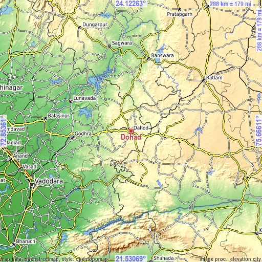
| Width | 9.01 km = 5.6 mi | 18.01 km = 11.2 mi | 288.2 km = 179.1 mi |
| Height | 9.01 km = 5.6 mi | 18.01 km = 11.2 mi | 288.2 km = 179.1 mi |
| ↑Max Latitude | 22.873326° | 22.913809° | 24.12263° |
| Latitude at center | 22.83283° | 22.83283° | 22.83283° |
| ↓Min Latitude | 22.792322° | 22.751802° | 21.53069° |
| ← Min Longitude | 74.215915° | 74.171969° | 72.85361° |
| Longitude center | 74.25986° | 74.25986° | 74.25986° |
| →Max Longitude | 74.303805° | 74.347751° | 75.66611° |
Nearby cities:
Cities around Dohad sort by population:
• Jhābua elevation 334 m
34.7 km,  102°
102°
• Rajpur 288 m
59.6 km,  170°
170°
• Chhota Udepur 150 m
63.9 km,  203°
203°
• Morwa 159 m
43.8 km,  280°
280°
• Devgadh Bāriya 201 m
38.7 km,  248°
248°
• Thandla 304 m
38 km,  58°
58°
• Petlāwad 398 m
58.5 km,  70°
70°
• Jobat 305 m
56.1 km,  145°
145°
• Rānāpur 377 m
33.8 km,  127°
127°
• Kushālgarh 293 m
45.2 km,  25°
25°
• Bhābhra 369 m
34.3 km, 168°
• Bamna 395 m
59 km, 60°
Multilingual:
 En español:
Dohad elevación 310 m.
 En France:
Dohad élévation 310 m.


Sources and notes:
- [note 1] Map square and city borders are not equal. Map elevation data is calculated only from area inside that square.
- [src 1] Elevation data from geonames database provided with same terms of usage.
- [src 2] The elevation map of Dohad is generated using elevation data from NASA's 3 arcsec (90m) resolution SRTM data.
- [src 3] Base (background) map © OpenStreetMap contributors tiles are generated by Geofabrik and OpenTopoMap.
Copyright & License:
This Dohad Elevation Map is licensed under CC BY-SA. You may reuse any part from this page, if you give a proper credit by linking to this URL:
 More info on terms of use page.