Bānswāra elevation
Bānswāra (Rajasthan), India elevation is 227 meters and Bānswāra elevation in feet is 745 ft above sea level [src 1]. Bānswāra is a populated place (feature code) with elevation that is 66 meters (217 ft) smaller than average city elevation in India.
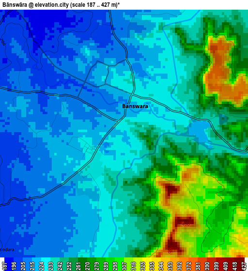
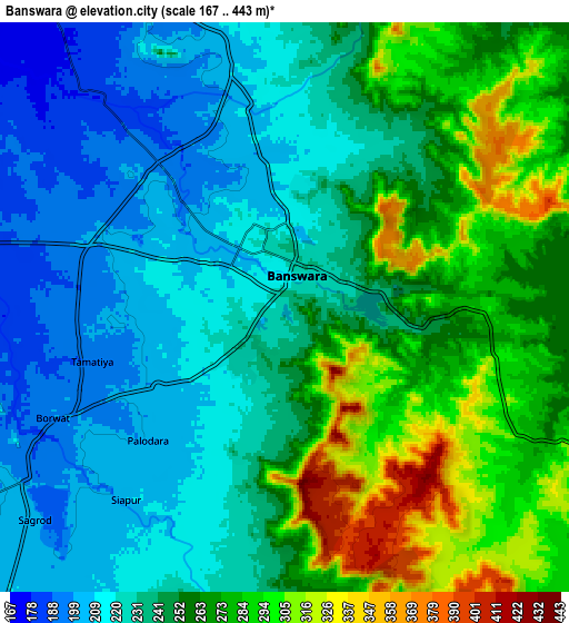
Below is the Elevation map of Bānswāra, which displays elevation range with different colors. Scale of the first map is from 187 to 427 m (614 to 1401 ft) with average elevation of 241.6 meters (=793 ft) [note 1]
These maps also provides idea of topography and contour of this city, they are displayed at different zoom levels. More info about maps, scale and edge coordinates you can find below images.
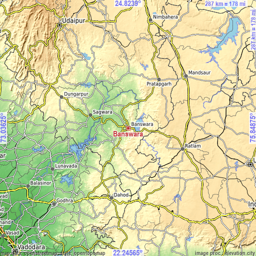
| \ | Map #1 | Map #2 | Topo.Map |
| Scale [m] | 187..427 m | 167..443 m | × |
| Scale [ft] | 614..1401 ft | 548..1453 ft | × |
| Average | 241.6 m = 793 ft | 248.4 m = 815 ft | × |
| Width | 8.96 km = 5.6 mi | 17.92 km = 11.1 mi | 286.7 km = 178.1 mi |
| Height | 8.96 km = 5.6 mi | 17.92 km = 11.1 mi | 286.7 km = 178.1 mi |
| ↑Max Latitude | 23.581372° | 23.621641° | 24.8239° |
| Latitude at center | 23.54109° | 23.54109° | 23.54109° |
| ↓Min Latitude | 23.500796° | 23.46049° | 22.24565° |
| ← Min Longitude | 74.398555° | 74.354609° | 73.03625° |
| Longitude center | 74.4425° | 74.4425° | 74.4425° |
| →Max Longitude | 74.486445° | 74.530391° | 75.84875° |
Nearby cities:
Cities around Bānswāra sort by population:
• Ratlām elevation 486 m
65.3 km,  111°
111°
• Jaorā 473 m
70.6 km,  81°
81°
• Pratāpgarh 498 m
64.6 km,  32°
32°
• Sālūmbar 242 m
77.5 km,  328°
328°
• Thandla 304 m
60.7 km,  166°
166°
• Petlāwad 398 m
69.2 km,  148°
148°
• Sailāna 547 m
49.8 km,  100°
100°
• Kushālgarh 293 m
38 km,  178°
178°
• Partāpur 155 m
28 km,  281°
281°
• Namli 494 m
63.6 km, 98°
• Bamna 395 m
59.4 km, 146°
• Galiākot 136 m
43.1 km,  266°
266°
Multilingual:
 En español:
Bānswāra elevación 227 m.
 En France:
Bānswāra élévation 227 m.
 Auf Deutsch:
Bānswāra höhe über dem Meeresspiegel ist 227 m.

Sources and notes:
- [note 1] Map square and city borders are not equal. Map elevation data is calculated only from area inside that square.
- [src 1] Elevation data from geonames database provided with same terms of usage.
- [src 2] The elevation map of Bānswāra is generated using elevation data from NASA's 3 arcsec (90m) resolution SRTM data.
- [src 3] Base (background) map © OpenStreetMap contributors tiles are generated by Geofabrik and OpenTopoMap.
Copyright & License:
This Bānswāra Elevation Map is licensed under CC BY-SA. You may reuse any part from this page, if you give a proper credit by linking to this URL:
 More info on terms of use page.