Ratlām elevation
Ratlām (Madhya Pradesh), India elevation is 486 meters and Ratlām elevation in feet is 1594 ft above sea level [src 1]. Ratlām is a populated place (feature code) with elevation that is 193 meters (633 ft) bigger than average city elevation in India.
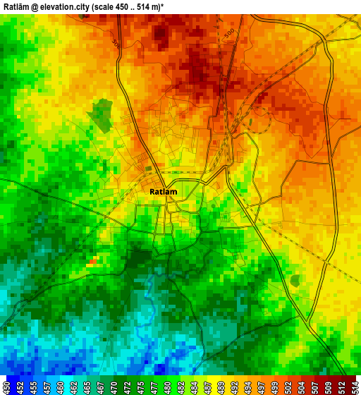
Below is the Elevation map of Ratlām, which displays elevation range with different colors. Scale of the first map is from 450 to 514 m (1476 to 1686 ft) with average elevation of 484.3 meters (=1589 ft) [note 1]
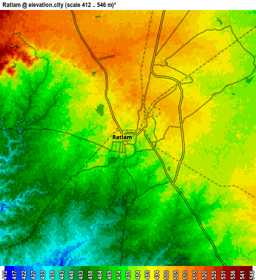
These maps also provides idea of topography and contour of this city, they are displayed at different zoom levels. More info about maps, scale and edge coordinates you can find below images.
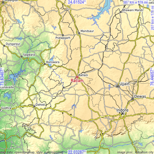
| \ | Map #1 | Map #2 | Topo.Map |
| Scale [m] | 450..514 m | 412..546 m | × |
| Scale [ft] | 1476..1686 ft | 1352..1791 ft | × |
| Average | 484.3 m = 1589 ft | 480 m = 1575 ft | × |
| Width | 8.97 km = 5.6 mi | 17.95 km = 11.2 mi | 287.1 km = 178.4 mi |
| Height | 8.97 km = 5.6 mi | 17.95 km = 11.2 mi | 287.1 km = 178.4 mi |
| ↑Max Latitude | 23.370676° | 23.41101° | 24.61524° |
| Latitude at center | 23.33033° | 23.33033° | 23.33033° |
| ↓Min Latitude | 23.289972° | 23.249601° | 22.03287° |
| ← Min Longitude | 74.996375° | 74.952429° | 73.63407° |
| Longitude center | 75.04032° | 75.04032° | 75.04032° |
| →Max Longitude | 75.084265° | 75.128211° | 76.44657° |
Nearby cities:
Cities around Ratlām sort by population:
• Nagda elevation 470 m
41 km,  69°
69°
• Jaorā 473 m
35.3 km,  14°
14°
• Khāchrod 493 m
26.7 km, 67°
• Badnāwar 515 m
39.5 km,  150°
150°
• Unhel 485 m
53 km,  89°
89°
• Tāl 455 m
55.8 km,  39°
39°
• Petlāwad 398 m
43.3 km,  214°
214°
• Sailāna 547 m
18.9 km,  320°
320°
• Namli 494 m
14.7 km, 8°
• Bamna 395 m
38.7 km,  227°
227°
• Piploda 469 m
40.2 km, 86°
• Gogāpur 491 m
54.8 km,  62°
62°
Multilingual:
 En español:
Ratlām elevación 486 m.
 En France:
Ratlām élévation 486 m.


Sources and notes:
- [note 1] Map square and city borders are not equal. Map elevation data is calculated only from area inside that square.
- [src 1] Elevation data from geonames database provided with same terms of usage.
- [src 2] The elevation map of Ratlām is generated using elevation data from NASA's 3 arcsec (90m) resolution SRTM data.
- [src 3] Base (background) map © OpenStreetMap contributors tiles are generated by Geofabrik and OpenTopoMap.
Copyright & License:
This Ratlām Elevation Map is licensed under CC BY-SA. You may reuse any part from this page, if you give a proper credit by linking to this URL:
 More info on terms of use page.