Modāsa elevation
Modāsa (Gujarat, Arvalli), India elevation is 147 meters and Modāsa elevation in feet is 482 ft above sea level [src 1]. Modāsa is a seat of a second-order administrative division (feature code) with elevation that is 146 meters (479 ft) smaller than average city elevation in India.
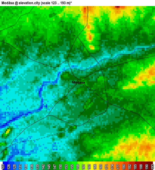
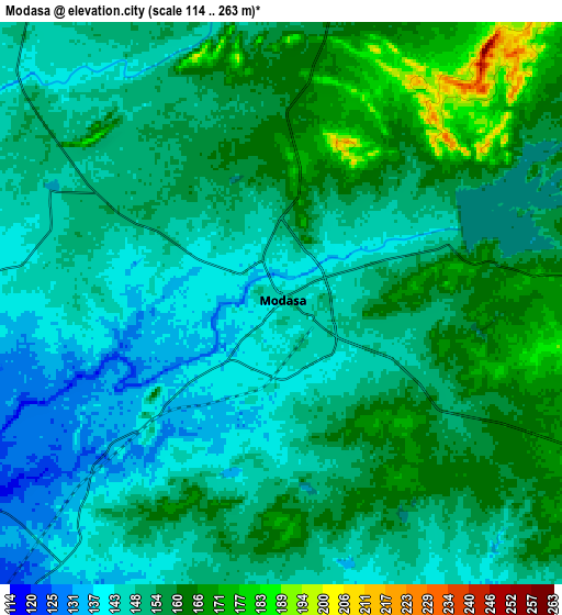
Below is the Elevation map of Modāsa, which displays elevation range with different colors. Scale of the first map is from 123 to 193 m (404 to 633 ft) with average elevation of 146.8 meters (=482 ft) [note 1]
These maps also provides idea of topography and contour of this city, they are displayed at different zoom levels. More info about maps, scale and edge coordinates you can find below images.
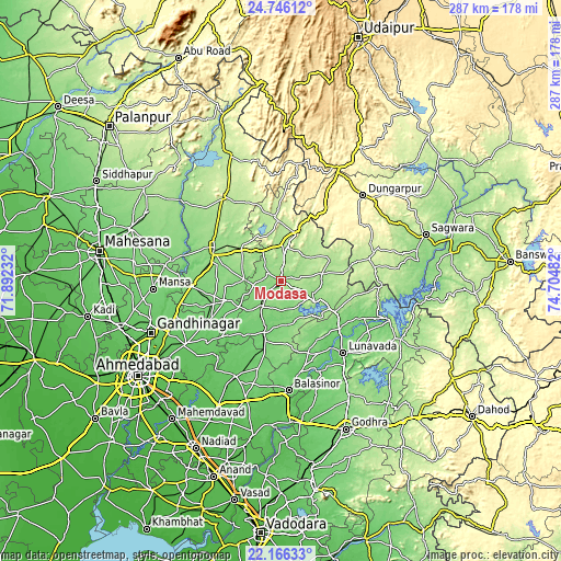
| \ | Map #1 | Map #2 | Topo.Map |
| Scale [m] | 123..193 m | 114..263 m | × |
| Scale [ft] | 404..633 ft | 374..863 ft | × |
| Average | 146.8 m = 482 ft | 152.8 m = 501 ft | × |
| Width | 8.96 km = 5.6 mi | 17.93 km = 11.1 mi | 286.8 km = 178.2 mi |
| Height | 8.96 km = 5.6 mi | 17.93 km = 11.1 mi | 286.9 km = 178.3 mi |
| ↑Max Latitude | 23.502836° | 23.543129° | 24.74612° |
| Latitude at center | 23.46253° | 23.46253° | 23.46253° |
| ↓Min Latitude | 23.422212° | 23.381882° | 22.16633° |
| ← Min Longitude | 73.254625° | 73.210679° | 71.89232° |
| Longitude center | 73.29857° | 73.29857° | 73.29857° |
| →Max Longitude | 73.342515° | 73.386461° | 74.70482° |
Nearby cities:
Cities around Modāsa sort by population:
• Himatnagar elevation 144 m
37.1 km,  294°
294°
• Dūngarpur 292 m
59.9 km,  45°
45°
• Kapadvanj 89 m
54.1 km,  205°
205°
• Dahegām 79 m
58.6 km,  236°
236°
• Lūnāvāda 104 m
48.9 km,  139°
139°
• Mānsa 106 m
65.5 km,  266°
266°
• Khedbrahma 209 m
68.1 km,  337°
337°
• Vijāpur 126 m
57.2 km,  281°
281°
• Chhala 97 m
56.2 km,  252°
252°
• Meghraj 168 m
22.3 km,  79°
79°
• Virpur 107 m
35.6 km,  148°
148°
• Mālpur 145 m
20.5 km,  123°
123°
Multilingual:
 En español:
Modāsa elevación 147 m.
 En France:
Modāsa élévation 147 m.


Sources and notes:
- [note 1] Map square and city borders are not equal. Map elevation data is calculated only from area inside that square.
- [src 1] Elevation data from geonames database provided with same terms of usage.
- [src 2] The elevation map of Modāsa is generated using elevation data from NASA's 3 arcsec (90m) resolution SRTM data.
- [src 3] Base (background) map © OpenStreetMap contributors tiles are generated by Geofabrik and OpenTopoMap.
Copyright & License:
This Modāsa Elevation Map is licensed under CC BY-SA. You may reuse any part from this page, if you give a proper credit by linking to this URL:
 More info on terms of use page.