Virpur elevation
Virpur (Gujarat, Kheda), India elevation is 107 meters and Virpur elevation in feet is 351 ft above sea level [src 1]. Virpur is a populated place (feature code) with elevation that is 186 meters (610 ft) smaller than average city elevation in India.
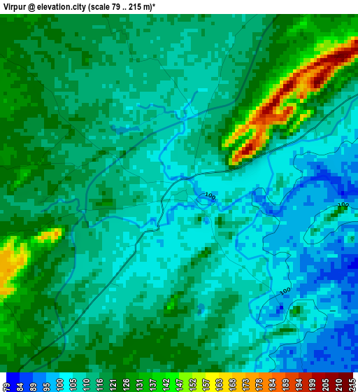
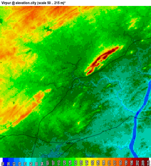
Below is the Elevation map of Virpur, which displays elevation range with different colors. Scale of the first map is from 79 to 215 m (259 to 705 ft) with average elevation of 115 meters (=377 ft) [note 1]
These maps also provides idea of topography and contour of this city, they are displayed at different zoom levels. More info about maps, scale and edge coordinates you can find below images.
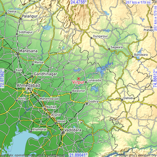
| \ | Map #1 | Map #2 | Topo.Map |
| Scale [m] | 79..215 m | 50..215 m | × |
| Scale [ft] | 259..705 ft | 164..705 ft | × |
| Average | 115 m = 377 ft | 117.9 m = 387 ft | × |
| Width | 8.98 km = 5.6 mi | 17.97 km = 11.2 mi | 287.4 km = 178.6 mi |
| Height | 8.98 km = 5.6 mi | 17.97 km = 11.2 mi | 287.5 km = 178.6 mi |
| ↑Max Latitude | 23.229589° | 23.269965° | 24.4755° |
| Latitude at center | 23.1892° | 23.1892° | 23.1892° |
| ↓Min Latitude | 23.148799° | 23.108386° | 21.89041° |
| ← Min Longitude | 73.435925° | 73.391979° | 72.07362° |
| Longitude center | 73.47987° | 73.47987° | 73.47987° |
| →Max Longitude | 73.523815° | 73.567761° | 74.88612° |
Nearby cities:
Cities around Virpur sort by population:
• Godhra elevation 132 m
48 km,  163°
163°
• Vejalpur 113 m
56.1 km,  171°
171°
• Modāsa 147 m
35.6 km,  328°
328°
• Kapadvanj 89 m
45.7 km,  246°
246°
• Lūnāvāda 104 m
15 km,  116°
116°
• Umreth 59 m
66.1 km,  214°
214°
• Kālol 88 m
64.7 km,  181°
181°
• Dākor 59 m
59.1 km, 214°
• Morwa 159 m
48.5 km,  130°
130°
• Thāsra 68 m
51.4 km, 212°
• Meghraj 168 m
34.5 km,  5°
5°
• Mālpur 145 m
19.1 km,  355°
355°
Multilingual:
 En español:
Virpur elevación 107 m.
 En France:
Virpur élévation 107 m.


Sources and notes:
- [note 1] Map square and city borders are not equal. Map elevation data is calculated only from area inside that square.
- [src 1] Elevation data from geonames database provided with same terms of usage.
- [src 2] The elevation map of Virpur is generated using elevation data from NASA's 3 arcsec (90m) resolution SRTM data.
- [src 3] Base (background) map © OpenStreetMap contributors tiles are generated by Geofabrik and OpenTopoMap.
Copyright & License:
This Virpur Elevation Map is licensed under CC BY-SA. You may reuse any part from this page, if you give a proper credit by linking to this URL:
 More info on terms of use page.