Jumri Tilaiyā elevation
Jumri Tilaiyā (Jharkhand, Kodarma), India elevation is 398 meters and Jumri Tilaiyā elevation in feet is 1306 ft above sea level [src 1]. Jumri Tilaiyā is a populated place (feature code) with elevation that is 105 meters (344 ft) bigger than average city elevation in India.
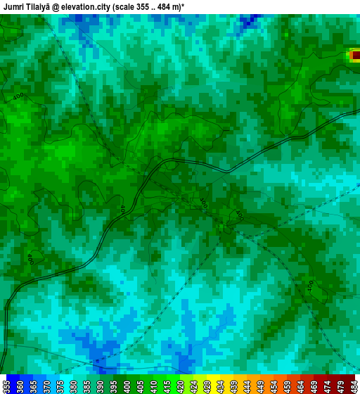
Below is the Elevation map of Jumri Tilaiyā, which displays elevation range with different colors. Scale of the first map is from 355 to 484 m (1165 to 1588 ft) with average elevation of 389.6 meters (=1278 ft) [note 1]
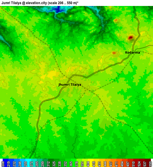
These maps also provides idea of topography and contour of this city, they are displayed at different zoom levels. More info about maps, scale and edge coordinates you can find below images.
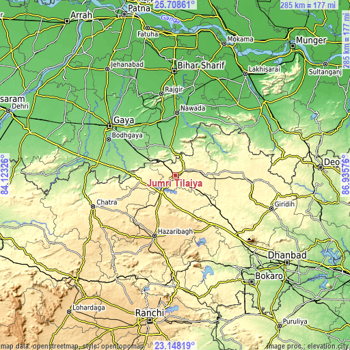
| \ | Map #1 | Map #2 | Topo.Map |
| Scale [m] | 355..484 m | 206..550 m | × |
| Scale [ft] | 1165..1588 ft | 676..1804 ft | × |
| Average | 389.6 m = 1278 ft | 375.4 m = 1232 ft | × |
| Width | 8.9 km = 5.5 mi | 17.79 km = 11.1 mi | 284.7 km = 176.9 mi |
| Height | 8.9 km = 5.5 mi | 17.79 km = 11.1 mi | 284.7 km = 176.9 mi |
| ↑Max Latitude | 24.474903° | 24.514893° | 25.70861° |
| Latitude at center | 24.4349° | 24.4349° | 24.4349° |
| ↓Min Latitude | 24.394884° | 24.354856° | 23.14819° |
| ← Min Longitude | 85.485565° | 85.441619° | 84.12326° |
| Longitude center | 85.52951° | 85.52951° | 85.52951° |
| →Max Longitude | 85.573455° | 85.617401° | 86.93576° |
Nearby cities:
Cities around Jumri Tilaiyā sort by population:
• Gaya elevation 117 m
66.7 km,  307°
307°
• Hazāribāgh 621 m
52.1 km,  199°
199°
• Nawāda 93 m
50.3 km,  1°
1°
• Bagaha 155 m
48.6 km,  282°
282°
• Wāris Alīganj 78 m
65.7 km,  9°
9°
• Buddh Gaya 124 m
62.2 km,  298°
298°
• Hisuā 101 m
45.8 km,  345°
345°
• Barki Saria 335 m
46.5 km,  128°
128°
• Kodarmā 390 m
7.5 km,  60°
60°
• patamda 390 m
18.9 km,  217°
217°
• Dhanwār 355 m
45.9 km,  93°
93°
• Hesla 370 m
54.4 km,  139°
139°
Multilingual:
 En español:
Jumri Tilaiyā elevación 398 m.
 En France:
Jumri Tilaiyā élévation 398 m.
 Auf Deutsch:
Jumri Tilaiyā höhe über dem Meeresspiegel ist 398 m.

Sources and notes:
- [note 1] Map square and city borders are not equal. Map elevation data is calculated only from area inside that square.
- [src 1] Elevation data from geonames database provided with same terms of usage.
- [src 2] The elevation map of Jumri Tilaiyā is generated using elevation data from NASA's 3 arcsec (90m) resolution SRTM data.
- [src 3] Base (background) map © OpenStreetMap contributors tiles are generated by Geofabrik and OpenTopoMap.
Copyright & License:
This Jumri Tilaiyā Elevation Map is licensed under CC BY-SA. You may reuse any part from this page, if you give a proper credit by linking to this URL:
 More info on terms of use page.