Bagaha elevation
Bagaha (Bihar, Gayā), India elevation is 155 meters and Bagaha elevation in feet is 509 ft above sea level [src 1]. Bagaha is a populated place (feature code) with elevation that is 138 meters (453 ft) smaller than average city elevation in India.
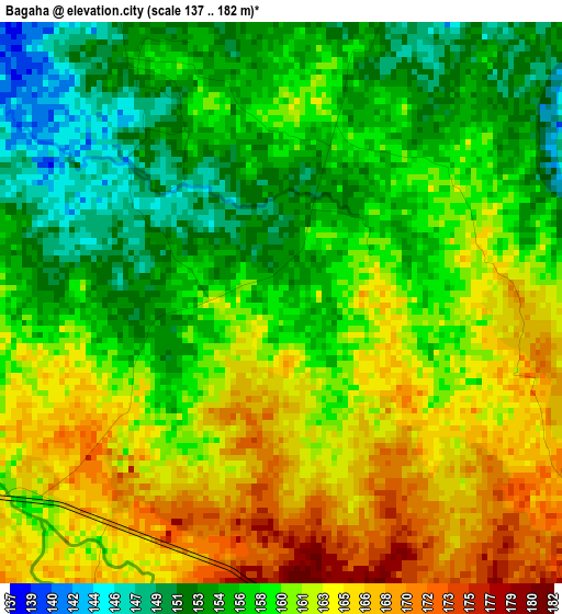
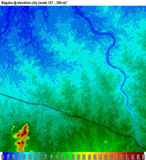
Below is the Elevation map of Bagaha, which displays elevation range with different colors. Scale of the first map is from 137 to 182 m (449 to 597 ft) with average elevation of 159.4 meters (=523 ft) [note 1]
These maps also provides idea of topography and contour of this city, they are displayed at different zoom levels. More info about maps, scale and edge coordinates you can find below images.
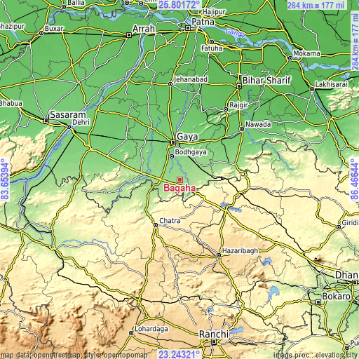
| \ | Map #1 | Map #2 | Topo.Map |
| Scale [m] | 137..182 m | 127..296 m | × |
| Scale [ft] | 449..597 ft | 417..971 ft | × |
| Average | 159.4 m = 523 ft | 161.3 m = 529 ft | × |
| Width | 8.89 km = 5.5 mi | 17.78 km = 11 mi | 284.5 km = 176.8 mi |
| Height | 8.89 km = 5.5 mi | 17.78 km = 11 mi | 284.5 km = 176.8 mi |
| ↑Max Latitude | 24.568953° | 24.608913° | 25.80172° |
| Latitude at center | 24.52898° | 24.52898° | 24.52898° |
| ↓Min Latitude | 24.488994° | 24.448996° | 23.24321° |
| ← Min Longitude | 85.016245° | 84.972299° | 83.65394° |
| Longitude center | 85.06019° | 85.06019° | 85.06019° |
| →Max Longitude | 85.104135° | 85.148081° | 86.46644° |
Nearby cities:
Cities around Bagaha sort by population:
• Gaya elevation 117 m
30.3 km,  349°
349°
• Nawāda 93 m
63 km,  50°
50°
• Jumri Tilaiyā 398 m
48.6 km,  102°
102°
• Chatrā 440 m
40.7 km,  208°
208°
• Rājgīr 85 m
66.4 km,  33°
33°
• Sherghāti 151 m
27.4 km,  277°
277°
• Buddh Gaya 124 m
20.2 km,  338°
338°
• Hisuā 101 m
49.5 km, 46°
• Rafiganj 106 m
53.7 km,  306°
306°
• Kodarmā 390 m
54.4 km, 97°
• Tekāri 97 m
51 km,  334°
334°
• patamda 390 m
44.2 km,  125°
125°
Multilingual:
 En español:
Bagaha elevación 155 m.
 En France:
Bagaha élévation 155 m.


Sources and notes:
- [note 1] Map square and city borders are not equal. Map elevation data is calculated only from area inside that square.
- [src 1] Elevation data from geonames database provided with same terms of usage.
- [src 2] The elevation map of Bagaha is generated using elevation data from NASA's 3 arcsec (90m) resolution SRTM data.
- [src 3] Base (background) map © OpenStreetMap contributors tiles are generated by Geofabrik and OpenTopoMap.
Copyright & License:
This Bagaha Elevation Map is licensed under CC BY-SA. You may reuse any part from this page, if you give a proper credit by linking to this URL:
 More info on terms of use page.