Rājgīr elevation
Rājgīr (Bihar, Nālanda), India elevation is 85 meters and Rājgīr elevation in feet is 279 ft above sea level [src 1]. Rājgīr is a populated place (feature code) with elevation that is 208 meters (682 ft) smaller than average city elevation in India.
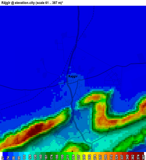
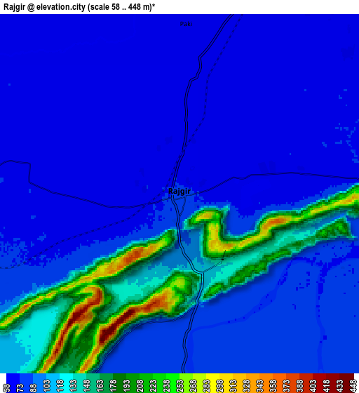
Below is the Elevation map of Rājgīr, which displays elevation range with different colors. Scale of the first map is from 61 to 387 m (200 to 1270 ft) with average elevation of 99.1 meters (=325 ft) [note 1]
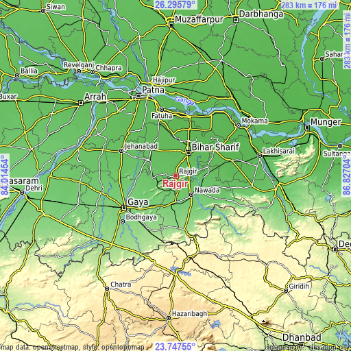
These maps also provides idea of topography and contour of this city, they are displayed at different zoom levels. More info about maps, scale and edge coordinates you can find below images.
| \ | Map #1 | Map #2 | Topo.Map |
| Scale [m] | 61..387 m | 58..448 m | × |
| Scale [ft] | 200..1270 ft | 190..1470 ft | × |
| Average | 99.1 m = 325 ft | 94.7 m = 311 ft | × |
| Width | 8.85 km = 5.5 mi | 17.71 km = 11 mi | 283.3 km = 176 mi |
| Height | 8.85 km = 5.5 mi | 17.71 km = 11 mi | 283.4 km = 176.1 mi |
| ↑Max Latitude | 25.068092° | 25.107892° | 26.29579° |
| Latitude at center | 25.02828° | 25.02828° | 25.02828° |
| ↓Min Latitude | 24.988455° | 24.948617° | 23.74755° |
| ← Min Longitude | 85.376845° | 85.332899° | 84.01454° |
| Longitude center | 85.42079° | 85.42079° | 85.42079° |
| →Max Longitude | 85.464735° | 85.508681° | 86.82704° |
Nearby cities:
Cities around Rājgīr sort by population:
• Gaya elevation 117 m
49.3 km,  238°
238°
• Bihār Sharīf 68 m
21.8 km,  28°
28°
• Nawāda 93 m
20 km,  141°
141°
• Jahānābād 71 m
48.3 km,  295°
295°
• Sheikhpura 54 m
44.1 km,  73°
73°
• Bar Bigha 55 m
37.9 km,  56°
56°
• Hilsa 60 m
34.9 km,  336°
336°
• Wāris Alīganj 78 m
22.2 km,  93°
93°
• Bakhtiyārpur 55 m
49.5 km,  13°
13°
• Islāmpur 73 m
25 km, 300°
• Hisuā 101 m
21.6 km,  180°
180°
• Silao 70 m
6.2 km, 6°
Multilingual:
 En español:
Rājgīr elevación 85 m.
 En France:
Rājgīr élévation 85 m.


Sources and notes:
- [note 1] Map square and city borders are not equal. Map elevation data is calculated only from area inside that square.
- [src 1] Elevation data from geonames database provided with same terms of usage.
- [src 2] The elevation map of Rājgīr is generated using elevation data from NASA's 3 arcsec (90m) resolution SRTM data.
- [src 3] Base (background) map © OpenStreetMap contributors tiles are generated by Geofabrik and OpenTopoMap.
Copyright & License:
This Rājgīr Elevation Map is licensed under CC BY-SA. You may reuse any part from this page, if you give a proper credit by linking to this URL:
 More info on terms of use page.