Hazāribāgh elevation
Hazāribāgh (Jharkhand, Hazārībāg), India elevation is 621 meters and Hazāribāgh elevation in feet is 2037 ft above sea level [src 1]. Hazāribāgh is a populated place (feature code) with elevation that is 328 meters (1076 ft) bigger than average city elevation in India.
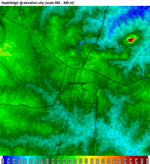
Below is the Elevation map of Hazāribāgh, which displays elevation range with different colors. Scale of the first map is from 569 to 688 m (1867 to 2257 ft) with average elevation of 607.9 meters (=1994 ft) [note 1]
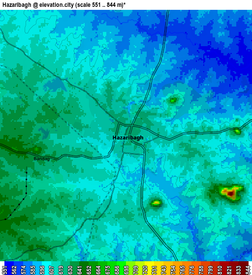
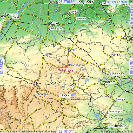
These maps also provides idea of topography and contour of this city, they are displayed at different zoom levels. More info about maps, scale and edge coordinates you can find below images.
| \ | Map #1 | Map #2 | Topo.Map |
| Scale [m] | 569..688 m | 551..844 m | × |
| Scale [ft] | 1867..2257 ft | 1808..2769 ft | × |
| Average | 607.9 m = 1994 ft | 605 m = 1985 ft | × |
| Width | 8.93 km = 5.5 mi | 17.86 km = 11.1 mi | 285.7 km = 177.5 mi |
| Height | 8.93 km = 5.5 mi | 17.86 km = 11.1 mi | 285.7 km = 177.5 mi |
| ↑Max Latitude | 24.032552° | 24.072682° | 25.27066° |
| Latitude at center | 23.99241° | 23.99241° | 23.99241° |
| ↓Min Latitude | 23.952255° | 23.912088° | 22.70134° |
| ← Min Longitude | 85.317675° | 85.273729° | 83.95537° |
| Longitude center | 85.36162° | 85.36162° | 85.36162° |
| →Max Longitude | 85.405565° | 85.449511° | 86.76787° |
Nearby cities:
Cities around Hazāribāgh sort by population:
• Rāmgarh elevation 339 m
43.4 km,  157°
157°
• Jumri Tilaiyā 398 m
52.1 km,  19°
19°
• Gumia 289 m
51.9 km,  114°
114°
• Chatrā 440 m
55.2 km,  295°
295°
• Barki Saria 335 m
57.3 km,  69°
69°
• Kuju 423 m
33.3 km,  153°
153°
• Kodarmā 390 m
57.8 km, 24°
• Barkā Kānā 354 m
42.7 km,  165°
165°
• Kānke 643 m
62.1 km,  183°
183°
• patamda 390 m
34.7 km,  9°
9°
• Hesla 370 m
53.1 km,  81°
81°
• Rāy 431 m
46.4 km,  222°
222°
Multilingual:
 En español:
Hazāribāgh elevación 621 m.
 En France:
Hazāribāgh élévation 621 m.
 Auf Deutsch:
Hazaribag höhe über dem Meeresspiegel ist 621 m.

Sources and notes:
- [note 1] Map square and city borders are not equal. Map elevation data is calculated only from area inside that square.
- [src 1] Elevation data from geonames database provided with same terms of usage.
- [src 2] The elevation map of Hazāribāgh is generated using elevation data from NASA's 3 arcsec (90m) resolution SRTM data.
- [src 3] Base (background) map © OpenStreetMap contributors tiles are generated by Geofabrik and OpenTopoMap.
Copyright & License:
This Hazāribāgh Elevation Map is licensed under CC BY-SA. You may reuse any part from this page, if you give a proper credit by linking to this URL:
 More info on terms of use page.