Bourbonne-les-Bains elevation
Bourbonne-les-Bains (Grand Est, Haute-Marne), France elevation is 273 meters and Bourbonne-les-Bains elevation in feet is 896 ft above sea level [src 1]. Bourbonne-les-Bains is a populated place (feature code) with elevation that is 99 meters (325 ft) bigger than average city elevation in France.
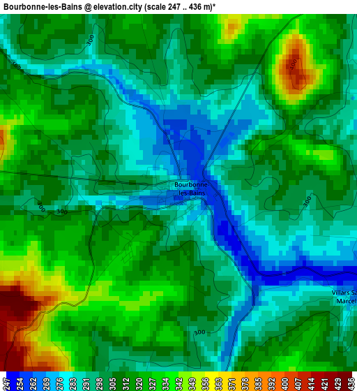
Below is the Elevation map of Bourbonne-les-Bains, which displays elevation range with different colors. Scale of the first map is from 247 to 436 m (810 to 1430 ft) with average elevation of 307.5 meters (=1009 ft) [note 1]
These maps also provides idea of topography and contour of this city, they are displayed at different zoom levels. More info about maps, scale and edge coordinates you can find below images.
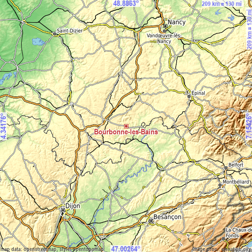
| \ | Map #1 | Topo.Map |
| Scale [m] | 247..436 m | × |
| Scale [ft] | 810..1430 ft | × |
| Average | 307.5 m = 1009 ft | × |
| Width | 6.54 km = 4.1 mi | 209.4 km = 130.1 mi |
| Height | 6.55 km = 4.1 mi | 209.4 km = 130.1 mi |
| ↑Max Latitude | 47.982474° | 48.8863° |
| Latitude at center | 47.95305° | 47.95305° |
| ↓Min Latitude | 47.92361° | 47.00264° |
| ← Min Longitude | 5.704065° | 4.34176° |
| Longitude center | 5.74801° | 5.74801° |
| →Max Longitude | 5.791955° | 7.15426° |
Nearby cities:
Cities around Bourbonne-les-Bains sort by population:
• Langres elevation 438 m
32.5 km,  251°
251°
• Vittel 337 m
31.3 km,  28°
28°
• Contrexéville 350 m
28 km,  23°
23°
• Nogent-le-Bas 327 m
31.7 km,  283°
283°
• Chalindrey 344 m
29.1 km,  235°
235°
• Val-de-Meuse 390 m
19.2 km,  285°
285°
• Jussey 224 m
18.3 km,  141°
141°
• Fayl-Billot 328 m
22 km,  210°
210°
• Bulgnéville 351 m
28.9 km,  12°
12°
• Darney 271 m
26.9 km,  56°
56°
• Lamarche 359 m
13.2 km, 10°
• Faverney 226 m
33.7 km,  127°
127°
Multilingual:
 En español:
Bourbonne-les-Bains elevación 273 m.
 En France:
Bourbonne-les-Bains élévation 273 m.
 Auf Deutsch:
Bourbonne-les-Bains höhe über dem Meeresspiegel ist 273 m.
 На русском:
Bourbonne-les-Bains высота над уровнем моря 273 м
Sources and notes:
- [note 1] Map square and city borders are not equal. Map elevation data is calculated only from area inside that square.
- [src 1] Elevation data from geonames database provided with same terms of usage.
- [src 2] The elevation map of Bourbonne-les-Bains is generated using elevation data from NASA's 3 arcsec (90m) resolution SRTM data.
- [src 3] Base (background) map © OpenStreetMap contributors tiles are generated by Geofabrik and OpenTopoMap.
Copyright & License:
This Bourbonne-les-Bains Elevation Map is licensed under CC BY-SA. You may reuse any part from this page, if you give a proper credit by linking to this URL:
 More info on terms of use page.