Bulgnéville elevation
Bulgnéville (Grand Est, Vosges), France elevation is 351 meters and Bulgnéville elevation in feet is 1152 ft above sea level [src 1]. Bulgnéville is a populated place (feature code) with elevation that is 177 meters (581 ft) bigger than average city elevation in France.
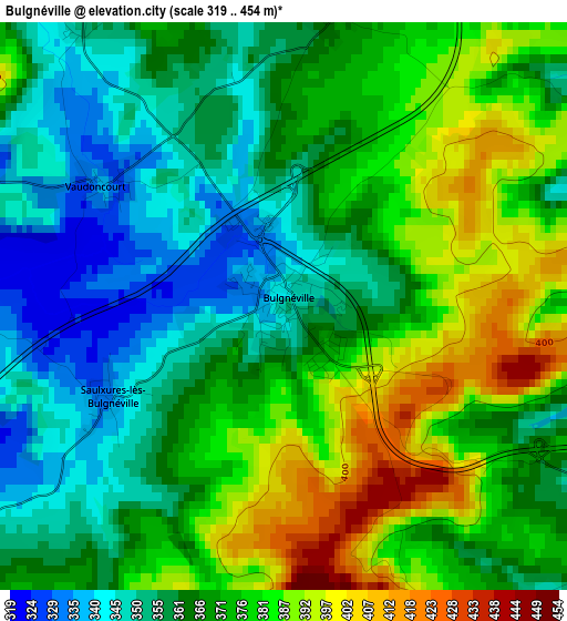
Below is the Elevation map of Bulgnéville, which displays elevation range with different colors. Scale of the first map is from 319 to 454 m (1047 to 1490 ft) with average elevation of 369.1 meters (=1211 ft) [note 1]
These maps also provides idea of topography and contour of this city, they are displayed at different zoom levels. More info about maps, scale and edge coordinates you can find below images.
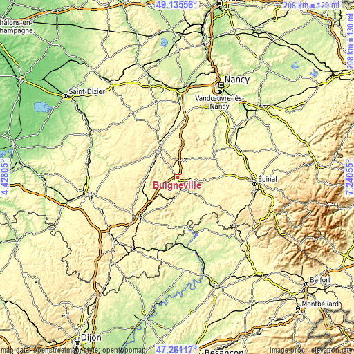
| \ | Map #1 | Topo.Map |
| Scale [m] | 319..454 m | × |
| Scale [ft] | 1047..1490 ft | × |
| Average | 369.1 m = 1211 ft | × |
| Width | 6.51 km = 4 mi | 208.4 km = 129.5 mi |
| Height | 6.51 km = 4 mi | 208.4 km = 129.5 mi |
| ↑Max Latitude | 48.236219° | 49.13556° |
| Latitude at center | 48.20694° | 48.20694° |
| ↓Min Latitude | 48.177645° | 47.26117° |
| ← Min Longitude | 5.790355° | 4.42805° |
| Longitude center | 5.8343° | 5.8343° |
| →Max Longitude | 5.878245° | 7.24055° |
Nearby cities:
Cities around Bulgnéville sort by population:
• Neufchâteau elevation 286 m
19.4 km,  328°
328°
• Mirecourt 282 m
24.4 km,  64°
64°
• Vittel 337 m
8.5 km,  94°
94°
• Contrexéville 350 m
5.2 km,  119°
119°
• Liffol-le-Grand 310 m
22.4 km,  303°
303°
• Bourbonne-les-Bains 273 m
28.9 km,  192°
192°
• Val-de-Meuse 390 m
33.8 km,  227°
227°
• Châtenois 330 m
10.7 km,  358°
358°
• Darney 271 m
20.8 km,  130°
130°
• Colombey-les-Belles 340 m
36.1 km,  7°
7°
• Vézelise 257 m
36.4 km,  31°
31°
• Lamarche 359 m
15.8 km, 194°
Multilingual:
 En español:
Bulgnéville elevación 351 m.
 En France:
Bulgnéville élévation 351 m.
 Auf Deutsch:
Bulgnéville höhe über dem Meeresspiegel ist 351 m.

Sources and notes:
- [note 1] Map square and city borders are not equal. Map elevation data is calculated only from area inside that square.
- [src 1] Elevation data from geonames database provided with same terms of usage.
- [src 2] The elevation map of Bulgnéville is generated using elevation data from NASA's 3 arcsec (90m) resolution SRTM data.
- [src 3] Base (background) map © OpenStreetMap contributors tiles are generated by Geofabrik and OpenTopoMap.
Copyright & License:
This Bulgnéville Elevation Map is licensed under CC BY-SA. You may reuse any part from this page, if you give a proper credit by linking to this URL:
 More info on terms of use page.