Langres elevation
Langres (Grand Est, Haute-Marne), France elevation is 438 meters and Langres elevation in feet is 1437 ft above sea level [src 1]. Langres is a seat of a third-order administrative division (feature code) with elevation that is 264 meters (866 ft) bigger than average city elevation in France.
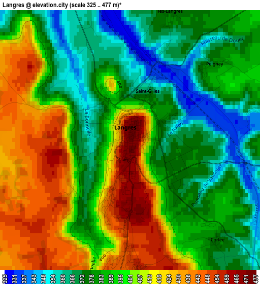
Below is the Elevation map of Langres, which displays elevation range with different colors. Scale of the first map is from 325 to 477 m (1066 to 1565 ft) with average elevation of 394.8 meters (=1295 ft) [note 1]
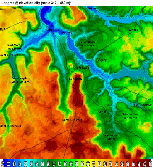
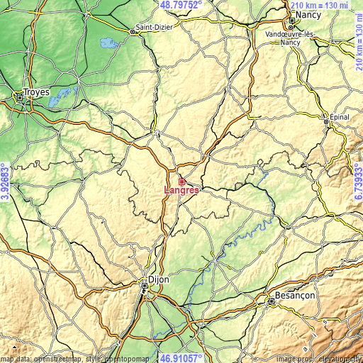
These maps also provides idea of topography and contour of this city, they are displayed at different zoom levels. More info about maps, scale and edge coordinates you can find below images.
| \ | Map #1 | Map #2 | Topo.Map |
| Scale [m] | 325..477 m | 312..480 m | × |
| Scale [ft] | 1066..1565 ft | 1024..1575 ft | × |
| Average | 394.8 m = 1295 ft | 398.3 m = 1307 ft | × |
| Width | 6.56 km = 4.1 mi | 13.11 km = 8.1 mi | 209.8 km = 130.4 mi |
| Height | 6.56 km = 4.1 mi | 13.11 km = 8.1 mi | 209.8 km = 130.4 mi |
| ↑Max Latitude | 47.892105° | 47.921563° | 48.79752° |
| Latitude at center | 47.86263° | 47.86263° | 47.86263° |
| ↓Min Latitude | 47.833138° | 47.80363° | 46.91057° |
| ← Min Longitude | 5.289135° | 5.245189° | 3.92683° |
| Longitude center | 5.33308° | 5.33308° | 5.33308° |
| →Max Longitude | 5.377025° | 5.420971° | 6.73933° |
Nearby cities:
Cities around Langres sort by population:
• Chaumont elevation 322 m
31.1 km,  332°
332°
• Nogent-le-Bas 327 m
17.5 km,  0°
0°
• Chalindrey 344 m
9.7 km,  133°
133°
• Selongey 298 m
32.4 km,  199°
199°
• Bourbonne-les-Bains 273 m
32.5 km,  71°
71°
• Val-de-Meuse 390 m
19.7 km,  39°
39°
• Champlitte-la-Ville 220 m
31.5 km,  151°
151°
• Champlitte 221 m
30.6 km, 153°
• Fayl-Billot 328 m
21.8 km,  114°
114°
• Rolampont 312 m
10.3 km,  339°
339°
• Biesles 389 m
25 km,  353°
353°
• Chamarandes-Choignes 339 m
28.1 km, 330°
Multilingual:
 En español:
Langres elevación 438 m.
 En France:
Langres élévation 438 m.


Sources and notes:
- [note 1] Map square and city borders are not equal. Map elevation data is calculated only from area inside that square.
- [src 1] Elevation data from geonames database provided with same terms of usage.
- [src 2] The elevation map of Langres is generated using elevation data from NASA's 3 arcsec (90m) resolution SRTM data.
- [src 3] Base (background) map © OpenStreetMap contributors tiles are generated by Geofabrik and OpenTopoMap.
Copyright & License:
This Langres Elevation Map is licensed under CC BY-SA. You may reuse any part from this page, if you give a proper credit by linking to this URL:
 More info on terms of use page.