Chamarandes-Choignes elevation
Chamarandes-Choignes (Grand Est, Haute-Marne), France elevation is 339 meters and Chamarandes-Choignes elevation in feet is 1112 ft above sea level [src 1]. Chamarandes-Choignes is a populated place (feature code) with elevation that is 165 meters (541 ft) bigger than average city elevation in France.
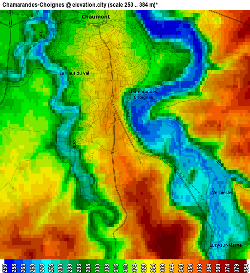
Below is the Elevation map of Chamarandes-Choignes, which displays elevation range with different colors. Scale of the first map is from 253 to 384 m (830 to 1260 ft) with average elevation of 319.6 meters (=1049 ft) [note 1]
These maps also provides idea of topography and contour of this city, they are displayed at different zoom levels. More info about maps, scale and edge coordinates you can find below images.
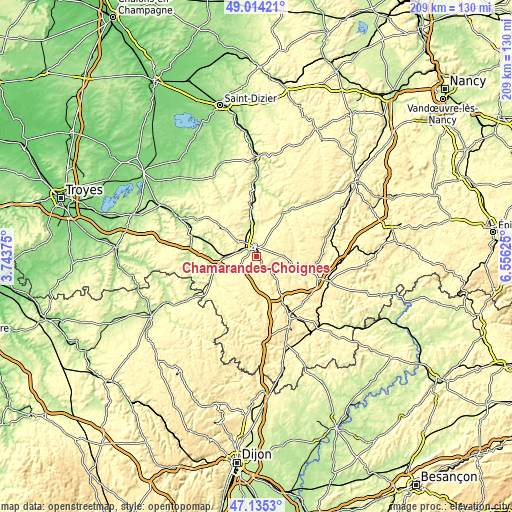
| \ | Map #1 | Topo.Map |
| Scale [m] | 253..384 m | × |
| Scale [ft] | 830..1260 ft | × |
| Average | 319.6 m = 1049 ft | × |
| Width | 6.53 km = 4.1 mi | 208.9 km = 129.8 mi |
| Height | 6.53 km = 4.1 mi | 208.9 km = 129.8 mi |
| ↑Max Latitude | 48.112679° | 49.01421° |
| Latitude at center | 48.08333° | 48.08333° |
| ↓Min Latitude | 48.053964° | 47.1353° |
| ← Min Longitude | 5.106055° | 3.74375° |
| Longitude center | 5.15° | 5.15° |
| →Max Longitude | 5.193945° | 6.55625° |
Nearby cities:
Cities around Chamarandes-Choignes sort by population:
• Chaumont elevation 322 m
3.2 km,  348°
348°
• Langres 438 m
28.1 km,  150°
150°
• Bar-sur-Aube 168 m
36.9 km,  296°
296°
• Nogent-le-Bas 327 m
15.3 km,  117°
117°
• Val-de-Meuse 390 m
27.6 km,  109°
109°
• Bologne 250 m
13 km,  357°
357°
• Châteauvillain 236 m
18 km,  253°
253°
• Froncles 223 m
23.8 km, 359°
• Rolampont 312 m
18 km, 145°
• Biesles 389 m
10.7 km,  88°
88°
• Ville-sous-la-Ferté 202 m
27.1 km,  278°
278°
• Doulaincourt-Saucourt 256 m
26.2 km,  8°
8°
Multilingual:
 En español:
Chamarandes-Choignes elevación 339 m.
 En France:
Chamarandes-Choignes élévation 339 m.
 Auf Deutsch:
Chamarandes-Choignes höhe über dem Meeresspiegel ist 339 m.
 На русском:
Chamarandes-Choignes высота над уровнем моря 339 м
Sources and notes:
- [note 1] Map square and city borders are not equal. Map elevation data is calculated only from area inside that square.
- [src 1] Elevation data from geonames database provided with same terms of usage.
- [src 2] The elevation map of Chamarandes-Choignes is generated using elevation data from NASA's 3 arcsec (90m) resolution SRTM data.
- [src 3] Base (background) map © OpenStreetMap contributors tiles are generated by Geofabrik and OpenTopoMap.
Copyright & License:
This Chamarandes-Choignes Elevation Map is licensed under CC BY-SA. You may reuse any part from this page, if you give a proper credit by linking to this URL:
 More info on terms of use page.