Montmorillon elevation
Montmorillon (Nouvelle-Aquitaine, Vienne), France elevation is 113 meters and Montmorillon elevation in feet is 371 ft above sea level [src 1]. Montmorillon is a seat of a third-order administrative division (feature code) with elevation that is 61 meters (200 ft) smaller than average city elevation in France.
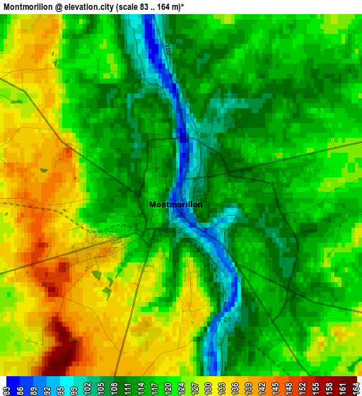
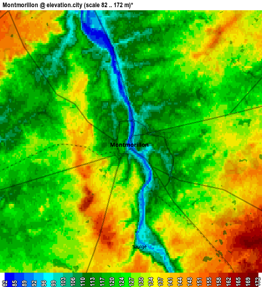
Below is the Elevation map of Montmorillon, which displays elevation range with different colors. Scale of the first map is from 83 to 164 m (272 to 538 ft) with average elevation of 120.5 meters (=395 ft) [note 1]
These maps also provides idea of topography and contour of this city, they are displayed at different zoom levels. More info about maps, scale and edge coordinates you can find below images.
| \ | Map #1 | Map #2 | Topo.Map |
| Scale [m] | 83..164 m | 82..172 m | × |
| Scale [ft] | 272..538 ft | 269..564 ft | × |
| Average | 120.5 m = 395 ft | 126 m = 413 ft | × |
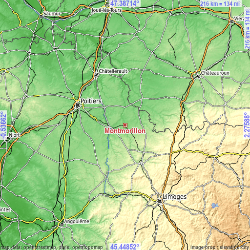
| Width | 6.74 km = 4.2 mi | 13.47 km = 8.4 mi | 215.6 km = 134 mi |
| Height | 6.74 km = 4.2 mi | 13.47 km = 8.4 mi | 215.5 km = 133.9 mi |
| ↑Max Latitude | 46.456732° | 46.486998° | 47.38714° |
| Latitude at center | 46.42645° | 46.42645° | 46.42645° |
| ↓Min Latitude | 46.396151° | 46.365835° | 45.44852° |
| ← Min Longitude | 0.825685° | 0.781739° | -0.53662° |
| Longitude center | 0.86963° | 0.86963° | 0.86963° |
| →Max Longitude | 0.913575° | 0.957521° | 2.27588° |
Nearby cities:
Cities around Montmorillon sort by population:
• Chauvigny elevation 89 m
23.5 km,  312°
312°
• Le Blanc 115 m
27.4 km,  32°
32°
• Lussac-les-Châteaux 104 m
11.5 km,  257°
257°
• Le Dorat 224 m
28.6 km,  145°
145°
• Bonnes 63 m
28.8 km, 313°
• Usson-du-Poitou 134 m
31 km,  237°
237°
• Lathus-Saint-Rémy 176 m
12.3 km, 146°
• Tercé 123 m
25.5 km,  293°
293°
• Saulgé 98 m
5.5 km,  174°
174°
• Saint-Savin 80 m
15.5 km,  358°
358°
• Bélâbre 106 m
26.1 km,  57°
57°
• Bussière-Poitevine 220 m
21.4 km, 172°
Multilingual:
 En español:
Montmorillon elevación 113 m.
 En France:
Montmorillon élévation 113 m.
 Auf Deutsch:
Montmorillon höhe über dem Meeresspiegel ist 113 m.

Sources and notes:
- [note 1] Map square and city borders are not equal. Map elevation data is calculated only from area inside that square.
- [src 1] Elevation data from geonames database provided with same terms of usage.
- [src 2] The elevation map of Montmorillon is generated using elevation data from NASA's 3 arcsec (90m) resolution SRTM data.
- [src 3] Base (background) map © OpenStreetMap contributors tiles are generated by Geofabrik and OpenTopoMap.
Copyright & License:
This Montmorillon Elevation Map is licensed under CC BY-SA. You may reuse any part from this page, if you give a proper credit by linking to this URL:
 More info on terms of use page.