Chauvigny elevation
Chauvigny (Nouvelle-Aquitaine, Vienne), France elevation is 89 meters and Chauvigny elevation in feet is 292 ft above sea level [src 1]. Chauvigny is a populated place (feature code) with elevation that is 85 meters (279 ft) smaller than average city elevation in France.
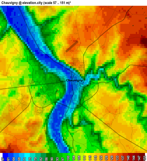
Below is the Elevation map of Chauvigny, which displays elevation range with different colors. Scale of the first map is from 57 to 151 m (187 to 495 ft) with average elevation of 107.3 meters (=352 ft) [note 1]
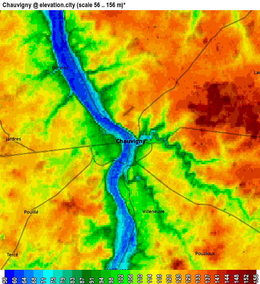
These maps also provides idea of topography and contour of this city, they are displayed at different zoom levels. More info about maps, scale and edge coordinates you can find below images.
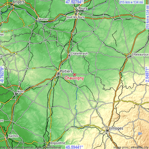
| \ | Map #1 | Map #2 | Topo.Map |
| Scale [m] | 57..151 m | 56..156 m | × |
| Scale [ft] | 187..495 ft | 184..512 ft | × |
| Average | 107.3 m = 352 ft | 116.1 m = 381 ft | × |
| Width | 6.72 km = 4.2 mi | 13.44 km = 8.4 mi | 215 km = 133.6 mi |
| Height | 6.72 km = 4.2 mi | 13.44 km = 8.4 mi | 215 km = 133.6 mi |
| ↑Max Latitude | 46.599993° | 46.630179° | 47.52794° |
| Latitude at center | 46.56979° | 46.56979° | 46.56979° |
| ↓Min Latitude | 46.53957° | 46.509334° | 45.59441° |
| ← Min Longitude | 0.599515° | 0.555569° | -0.76279° |
| Longitude center | 0.64346° | 0.64346° | 0.64346° |
| →Max Longitude | 0.687405° | 0.731351° | 2.04971° |
Nearby cities:
Cities around Chauvigny sort by population:
• Buxerolles elevation 123 m
13.3 km,  293°
293°
• Mignaloux-Beauvoir 121 m
17.8 km,  260°
260°
• Montamisé 116 m
17.7 km, 289°
• Sèvres-Anxaumont 113 m
13.6 km,  269°
269°
• Bonneuil-Matours 62 m
13.7 km,  335°
335°
• Bonnes 63 m
5.3 km,  316°
316°
• Tercé 123 m
8.5 km,  226°
226°
• Saint-Savin 80 m
16.8 km,  91°
91°
• Lavoux 118 m
9.2 km, 288°
• Archigny 131 m
11.5 km,  3°
3°
• Bignoux 119 m
13.7 km,  284°
284°
• Savigny-Lévescault 115 m
13.3 km,  253°
253°
Multilingual:
 En español:
Chauvigny elevación 89 m.
 En France:
Chauvigny élévation 89 m.
 Auf Deutsch:
Chauvigny höhe über dem Meeresspiegel ist 89 m.

Sources and notes:
- [note 1] Map square and city borders are not equal. Map elevation data is calculated only from area inside that square.
- [src 1] Elevation data from geonames database provided with same terms of usage.
- [src 2] The elevation map of Chauvigny is generated using elevation data from NASA's 3 arcsec (90m) resolution SRTM data.
- [src 3] Base (background) map © OpenStreetMap contributors tiles are generated by Geofabrik and OpenTopoMap.
Copyright & License:
This Chauvigny Elevation Map is licensed under CC BY-SA. You may reuse any part from this page, if you give a proper credit by linking to this URL:
 More info on terms of use page.