Lathus-Saint-Rémy elevation
Lathus-Saint-Rémy (Nouvelle-Aquitaine, Vienne), France elevation is 176 meters and Lathus-Saint-Rémy elevation in feet is 577 ft above sea level [src 1]. Lathus-Saint-Rémy is a populated place (feature code) with elevation that is 2 meters (7 ft) bigger than average city elevation in France.
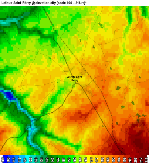
Below is the Elevation map of Lathus-Saint-Rémy, which displays elevation range with different colors. Scale of the first map is from 104 to 216 m (341 to 709 ft) with average elevation of 171.7 meters (=563 ft) [note 1]
These maps also provides idea of topography and contour of this city, they are displayed at different zoom levels. More info about maps, scale and edge coordinates you can find below images.
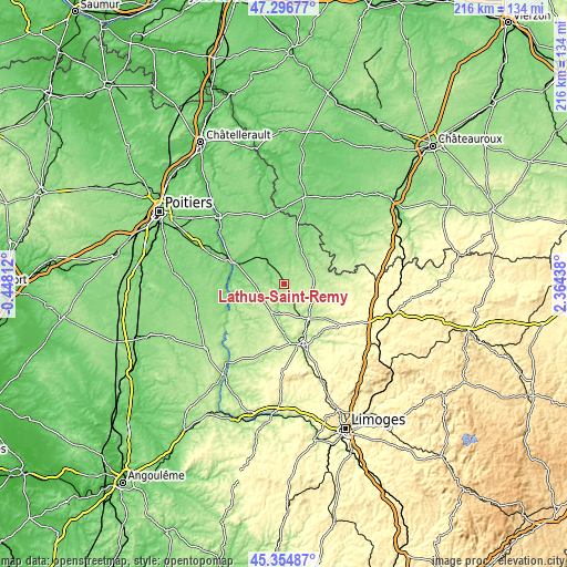
| \ | Map #1 | Topo.Map |
| Scale [m] | 104..216 m | × |
| Scale [ft] | 341..709 ft | × |
| Average | 171.7 m = 563 ft | × |
| Width | 6.75 km = 4.2 mi | 215.9 km = 134.2 mi |
| Height | 6.75 km = 4.2 mi | 215.9 km = 134.2 mi |
| ↑Max Latitude | 46.364774° | 47.29677° |
| Latitude at center | 46.33444° | 46.33444° |
| ↓Min Latitude | 46.30409° | 45.35487° |
| ← Min Longitude | 0.914185° | -0.44812° |
| Longitude center | 0.95813° | 0.95813° |
| →Max Longitude | 1.002075° | 2.36438° |
Nearby cities:
Cities around Lathus-Saint-Rémy sort by population:
• Montmorillon elevation 113 m
12.3 km,  326°
326°
• Bellac 244 m
24.6 km,  163°
163°
• Lussac-les-Châteaux 104 m
19.6 km,  293°
293°
• Magnac-Laval 232 m
20.8 km,  129°
129°
• Le Dorat 224 m
16.4 km,  144°
144°
• Saint-Sulpice-les-Feuilles 289 m
31.5 km,  93°
93°
• Chaillac 186 m
28.4 km,  67°
67°
• Peyrat-de-Bellac 250 m
22.3 km, 164°
• Saulgé 98 m
7.9 km,  307°
307°
• Saint-Savin 80 m
26.7 km,  344°
344°
• Bélâbre 106 m
28.6 km,  32°
32°
• Bussière-Poitevine 220 m
11.8 km,  200°
200°
Multilingual:
 En español:
Lathus-Saint-Rémy elevación 176 m.
 En France:
Lathus, Lathus-Saint-Rémy élévation 176 m.
 Auf Deutsch:
Lathus-Saint-Rémy höhe über dem Meeresspiegel ist 176 m.

Sources and notes:
- [note 1] Map square and city borders are not equal. Map elevation data is calculated only from area inside that square.
- [src 1] Elevation data from geonames database provided with same terms of usage.
- [src 2] The elevation map of Lathus-Saint-Rémy is generated using elevation data from NASA's 3 arcsec (90m) resolution SRTM data.
- [src 3] Base (background) map © OpenStreetMap contributors tiles are generated by Geofabrik and OpenTopoMap.
Copyright & License:
This Lathus-Saint-Rémy Elevation Map is licensed under CC BY-SA. You may reuse any part from this page, if you give a proper credit by linking to this URL:
 More info on terms of use page.