Bussière-Poitevine elevation
Bussière-Poitevine (Nouvelle-Aquitaine, Haute-Vienne), France elevation is 220 meters and Bussière-Poitevine elevation in feet is 722 ft above sea level [src 1]. Bussière-Poitevine is a populated place (feature code) with elevation that is 46 meters (151 ft) bigger than average city elevation in France.
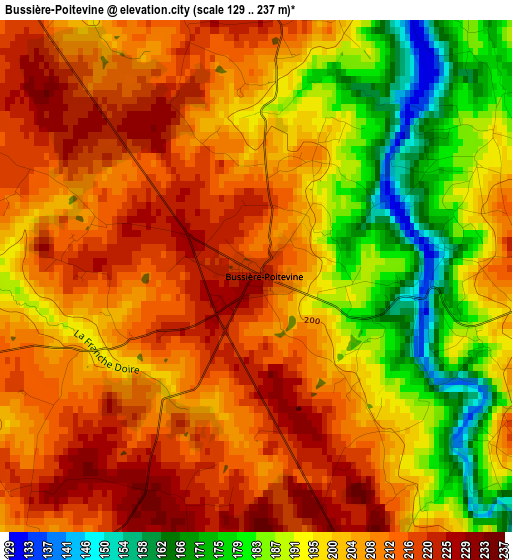
Below is the Elevation map of Bussière-Poitevine, which displays elevation range with different colors. Scale of the first map is from 129 to 237 m (423 to 778 ft) with average elevation of 202.4 meters (=664 ft) [note 1]
These maps also provides idea of topography and contour of this city, they are displayed at different zoom levels. More info about maps, scale and edge coordinates you can find below images.
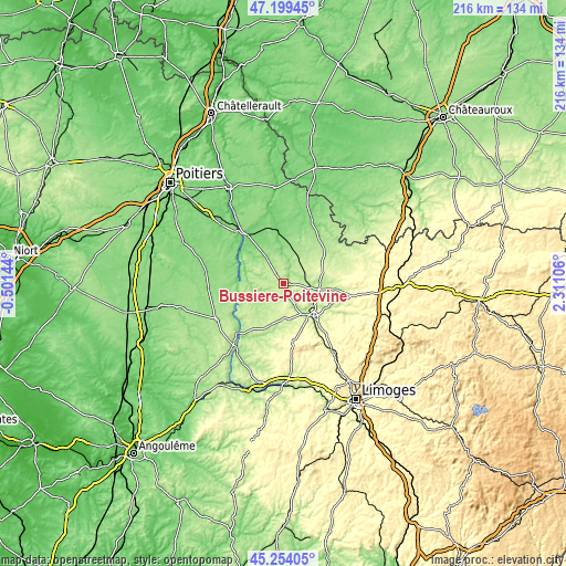
| \ | Map #1 | Topo.Map |
| Scale [m] | 129..237 m | × |
| Scale [ft] | 423..778 ft | × |
| Average | 202.4 m = 664 ft | × |
| Width | 6.76 km = 4.2 mi | 216.3 km = 134.4 mi |
| Height | 6.76 km = 4.2 mi | 216.3 km = 134.4 mi |
| ↑Max Latitude | 46.265758° | 47.19945° |
| Latitude at center | 46.23537° | 46.23537° |
| ↓Min Latitude | 46.204965° | 45.25405° |
| ← Min Longitude | 0.860865° | -0.50144° |
| Longitude center | 0.90481° | 0.90481° |
| →Max Longitude | 0.948755° | 2.31106° |
Nearby cities:
Cities around Bussière-Poitevine sort by population:
• Montmorillon elevation 113 m
21.4 km,  352°
352°
• Bellac 244 m
16.8 km,  138°
138°
• Confolens 157 m
30.5 km,  216°
216°
• Lussac-les-Châteaux 104 m
23.3 km,  323°
323°
• Châteauponsac 289 m
30.6 km,  111°
111°
• Magnac-Laval 232 m
20.2 km,  96°
96°
• Le Dorat 224 m
13.8 km, 99°
• Usson-du-Poitou 134 m
29.4 km,  279°
279°
• Availles-Limouzine 132 m
23 km,  236°
236°
• Lathus-Saint-Rémy 176 m
11.8 km,  20°
20°
• Peyrat-de-Bellac 250 m
14.5 km, 135°
• Saulgé 98 m
16 km, 352°
Multilingual:
 En español:
Bussière-Poitevine elevación 220 m.
 En France:
Bussière-Poitevine élévation 220 m.
 Auf Deutsch:
Bussière-Poitevine höhe über dem Meeresspiegel ist 220 m.
 На русском:
Bussière-Poitevine высота над уровнем моря 220 м
Sources and notes:
- [note 1] Map square and city borders are not equal. Map elevation data is calculated only from area inside that square.
- [src 1] Elevation data from geonames database provided with same terms of usage.
- [src 2] The elevation map of Bussière-Poitevine is generated using elevation data from NASA's 3 arcsec (90m) resolution SRTM data.
- [src 3] Base (background) map © OpenStreetMap contributors tiles are generated by Geofabrik and OpenTopoMap.
Copyright & License:
This Bussière-Poitevine Elevation Map is licensed under CC BY-SA. You may reuse any part from this page, if you give a proper credit by linking to this URL:
 More info on terms of use page.