Confolens elevation
Confolens (Nouvelle-Aquitaine, Charente), France elevation is 157 meters and Confolens elevation in feet is 515 ft above sea level [src 1]. Confolens is a seat of a third-order administrative division (feature code) with elevation that is 17 meters (56 ft) smaller than average city elevation in France.
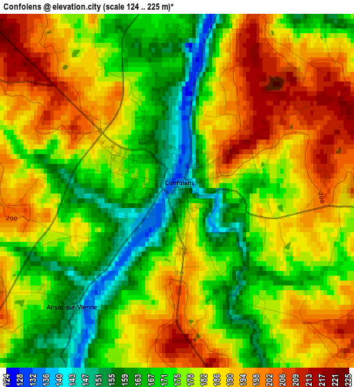
Below is the Elevation map of Confolens, which displays elevation range with different colors. Scale of the first map is from 124 to 225 m (407 to 738 ft) with average elevation of 180 meters (=591 ft) [note 1]
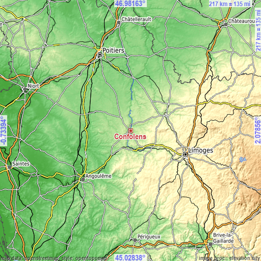
These maps also provides idea of topography and contour of this city, they are displayed at different zoom levels. More info about maps, scale and edge coordinates you can find below images.
| \ | Map #1 | Topo.Map |
| Scale [m] | 124..225 m | × |
| Scale [ft] | 407..738 ft | × |
| Average | 180 m = 591 ft | × |
| Width | 6.79 km = 4.2 mi | 217.2 km = 135 mi |
| Height | 6.79 km = 4.2 mi | 217.2 km = 135 mi |
| ↑Max Latitude | 46.044141° | 46.98163° |
| Latitude at center | 46.01363° | 46.01363° |
| ↓Min Latitude | 45.983102° | 45.02838° |
| ← Min Longitude | 0.628365° | -0.73394° |
| Longitude center | 0.67231° | 0.67231° |
| →Max Longitude | 0.716255° | 2.07856° |
Nearby cities:
Cities around Confolens sort by population:
• Saint-Junien elevation 223 m
22.6 km,  128°
128°
• Rochechouart 214 m
24.1 km,  151°
151°
• Loubert 176 m
12.9 km,  211°
211°
• Roumazières-Loubert 219 m
15.8 km, 206°
• Chabanais 155 m
16 km,  167°
167°
• Charroux 140 m
25.3 km,  305°
305°
• Availles-Limouzine 132 m
12 km,  353°
353°
• Saint-Claud 156 m
20.8 km,  230°
230°
• Exideuil 152 m
14.1 km,  179°
179°
• Brigueuil 291 m
16 km,  114°
114°
• Champagne-Mouton 144 m
20.4 km,  262°
262°
• Étagnac 241 m
15.5 km, 147°
Multilingual:
 En español:
Confolens elevación 157 m.
 En France:
Confolens élévation 157 m.
 Auf Deutsch:
Confolens höhe über dem Meeresspiegel ist 157 m.

Sources and notes:
- [note 1] Map square and city borders are not equal. Map elevation data is calculated only from area inside that square.
- [src 1] Elevation data from geonames database provided with same terms of usage.
- [src 2] The elevation map of Confolens is generated using elevation data from NASA's 3 arcsec (90m) resolution SRTM data.
- [src 3] Base (background) map © OpenStreetMap contributors tiles are generated by Geofabrik and OpenTopoMap.
Copyright & License:
This Confolens Elevation Map is licensed under CC BY-SA. You may reuse any part from this page, if you give a proper credit by linking to this URL:
 More info on terms of use page.