Rochechouart elevation
Rochechouart (Nouvelle-Aquitaine, Haute-Vienne), France elevation is 214 meters and Rochechouart elevation in feet is 702 ft above sea level [src 1]. Rochechouart is a seat of a third-order administrative division (feature code) with elevation that is 40 meters (131 ft) bigger than average city elevation in France.
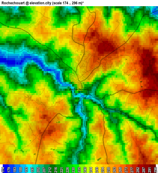
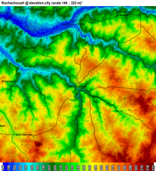
Below is the Elevation map of Rochechouart, which displays elevation range with different colors. Scale of the first map is from 174 to 296 m (571 to 971 ft) with average elevation of 241.7 meters (=793 ft) [note 1]
These maps also provides idea of topography and contour of this city, they are displayed at different zoom levels. More info about maps, scale and edge coordinates you can find below images.
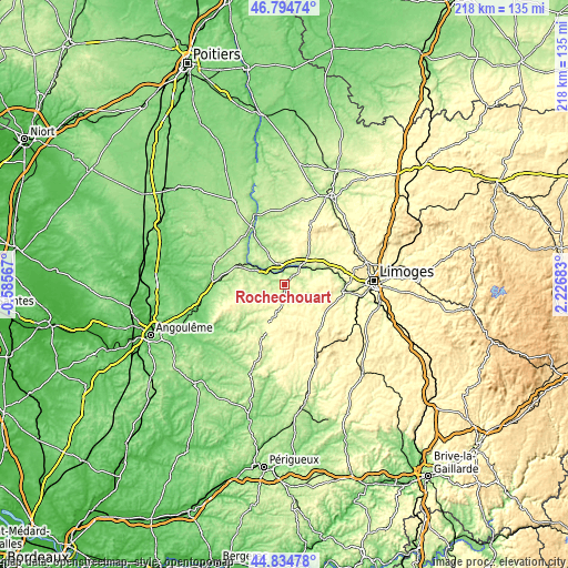
| \ | Map #1 | Map #2 | Topo.Map |
| Scale [m] | 174..296 m | 149..323 m | × |
| Scale [ft] | 571..971 ft | 489..1060 ft | × |
| Average | 241.7 m = 793 ft | 238.5 m = 782 ft | × |
| Width | 6.81 km = 4.2 mi | 13.62 km = 8.5 mi | 217.9 km = 135.4 mi |
| Height | 6.81 km = 4.2 mi | 13.62 km = 8.5 mi | 217.9 km = 135.4 mi |
| ↑Max Latitude | 45.853996° | 45.884595° | 46.79474° |
| Latitude at center | 45.82338° | 45.82338° | 45.82338° |
| ↓Min Latitude | 45.792747° | 45.762098° | 44.83478° |
| ← Min Longitude | 0.776635° | 0.732689° | -0.58567° |
| Longitude center | 0.82058° | 0.82058° | 0.82058° |
| →Max Longitude | 0.864525° | 0.908471° | 2.22683° |
Nearby cities:
Cities around Rochechouart sort by population:
• Saint-Junien elevation 223 m
9.5 km,  41°
41°
• Chabanais 155 m
9.7 km,  304°
304°
• Oradour-sur-Vayres 352 m
10.8 km,  160°
160°
• Saint-Victurnien 194 m
16.1 km,  67°
67°
• Saint-Laurent-sur-Gorre 262 m
12.2 km,  119°
119°
• Saint-Brice-sur-Vienne 212 m
12.1 km,  58°
58°
• Cussac 344 m
13.2 km,  170°
170°
• Saint-Mathieu 324 m
13.9 km,  200°
200°
• Cognac-la-Forêt 344 m
14.7 km,  85°
85°
• Exideuil 152 m
13.4 km, 301°
• Brigueuil 291 m
14.8 km,  12°
12°
• Étagnac 241 m
8.6 km,  337°
337°
Multilingual:
 En español:
Rochechouart elevación 214 m.
 En France:
Rochechouart élévation 214 m.
 Auf Deutsch:
Rochechouart höhe über dem Meeresspiegel ist 214 m.

Sources and notes:
- [note 1] Map square and city borders are not equal. Map elevation data is calculated only from area inside that square.
- [src 1] Elevation data from geonames database provided with same terms of usage.
- [src 2] The elevation map of Rochechouart is generated using elevation data from NASA's 3 arcsec (90m) resolution SRTM data.
- [src 3] Base (background) map © OpenStreetMap contributors tiles are generated by Geofabrik and OpenTopoMap.
Copyright & License:
This Rochechouart Elevation Map is licensed under CC BY-SA. You may reuse any part from this page, if you give a proper credit by linking to this URL:
 More info on terms of use page.