Cognac-la-Forêt elevation
Cognac-la-Forêt (Nouvelle-Aquitaine, Haute-Vienne), France elevation is 344 meters and Cognac-la-Forêt elevation in feet is 1129 ft above sea level [src 1]. Cognac-la-Forêt is a populated place (feature code) with elevation that is 170 meters (558 ft) bigger than average city elevation in France.
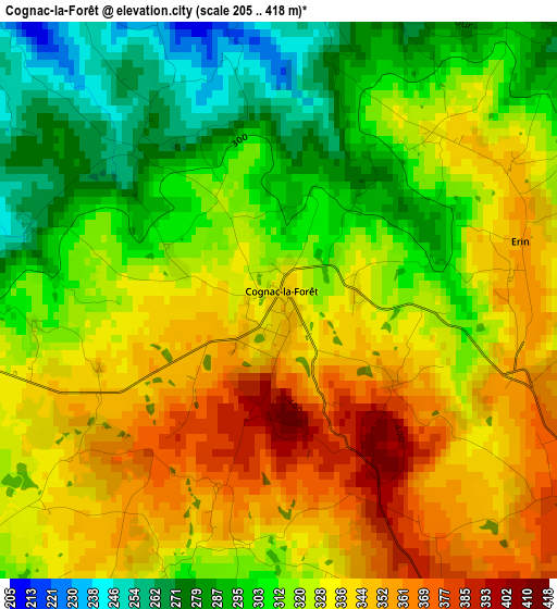
Below is the Elevation map of Cognac-la-Forêt, which displays elevation range with different colors. Scale of the first map is from 205 to 418 m (673 to 1371 ft) with average elevation of 322.7 meters (=1059 ft) [note 1]
These maps also provides idea of topography and contour of this city, they are displayed at different zoom levels. More info about maps, scale and edge coordinates you can find below images.
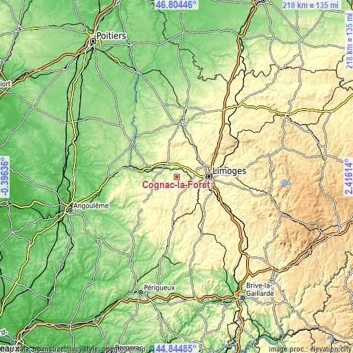
| \ | Map #1 | Topo.Map |
| Scale [m] | 205..418 m | × |
| Scale [ft] | 673..1371 ft | × |
| Average | 322.7 m = 1059 ft | × |
| Width | 6.81 km = 4.2 mi | 217.9 km = 135.4 mi |
| Height | 6.81 km = 4.2 mi | 217.9 km = 135.4 mi |
| ↑Max Latitude | 45.86389° | 46.80446° |
| Latitude at center | 45.83328° | 45.83328° |
| ↓Min Latitude | 45.802653° | 44.84485° |
| ← Min Longitude | 0.965945° | -0.39636° |
| Longitude center | 1.00989° | 1.00989° |
| →Max Longitude | 1.053835° | 2.41614° |
Nearby cities:
Cities around Cognac-la-Forêt sort by population:
• Saint-Junien elevation 223 m
10.3 km,  305°
305°
• Aixe-sur-Vienne 222 m
10.6 km,  112°
112°
• Rochechouart 214 m
14.7 km,  265°
265°
• Verneuil-sur-Vienne 312 m
9.2 km,  79°
79°
• Oradour-sur-Glane 259 m
11.2 km,  8°
8°
• Veyrac 310 m
10.3 km,  46°
46°
• Séreilhac 313 m
9 km,  141°
141°
• Saint-Victurnien 194 m
4.9 km,  2°
2°
• Saint-Gence 309 m
14 km, 45°
• Saint-Priest-sous-Aixe 283 m
7.2 km,  104°
104°
• Saint-Laurent-sur-Gorre 262 m
8.2 km,  209°
209°
• Saint-Brice-sur-Vienne 212 m
6.8 km,  319°
319°
Multilingual:
 En español:
Cognac-la-Forêt elevación 344 m.
 En France:
Cognac-le-Frold, Cognac-la-Forêt, Cognac-le-Froid élévation 344 m.
 Auf Deutsch:
Cognac-la-Forêt höhe über dem Meeresspiegel ist 344 m.

Sources and notes:
- [note 1] Map square and city borders are not equal. Map elevation data is calculated only from area inside that square.
- [src 1] Elevation data from geonames database provided with same terms of usage.
- [src 2] The elevation map of Cognac-la-Forêt is generated using elevation data from NASA's 3 arcsec (90m) resolution SRTM data.
- [src 3] Base (background) map © OpenStreetMap contributors tiles are generated by Geofabrik and OpenTopoMap.
Copyright & License:
This Cognac-la-Forêt Elevation Map is licensed under CC BY-SA. You may reuse any part from this page, if you give a proper credit by linking to this URL:
 More info on terms of use page.