Andosilla elevation
Andosilla (Navarre, Provincia de Navarra), Spain elevation is 316 meters and Andosilla elevation in feet is 1037 ft above sea level [src 1]. Andosilla is a seat of a third-order administrative division (feature code) with elevation that is 287 meters (942 ft) smaller than average city elevation in Spain.
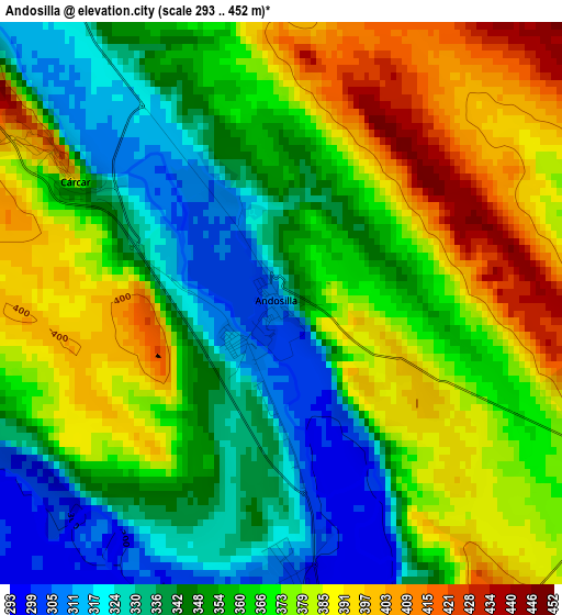
Below is the Elevation map of Andosilla, which displays elevation range with different colors. Scale of the first map is from 293 to 452 m (961 to 1483 ft) with average elevation of 362.2 meters (=1188 ft) [note 1]
These maps also provides idea of topography and contour of this city, they are displayed at different zoom levels. More info about maps, scale and edge coordinates you can find below images.
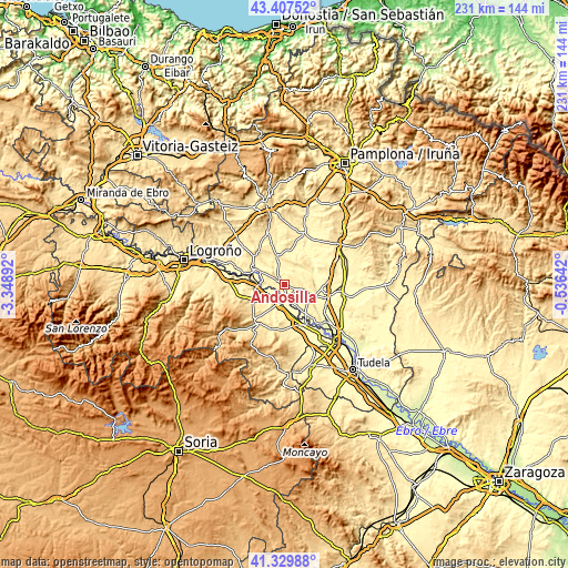
| \ | Map #1 | Topo.Map |
| Scale [m] | 293..452 m | × |
| Scale [ft] | 961..1483 ft | × |
| Average | 362.2 m = 1188 ft | × |
| Width | 7.22 km = 4.5 mi | 231 km = 143.5 mi |
| Height | 7.22 km = 4.5 mi | 231 km = 143.5 mi |
| ↑Max Latitude | 42.409745° | 43.40752° |
| Latitude at center | 42.37729° | 42.37729° |
| ↓Min Latitude | 42.344818° | 41.32988° |
| ← Min Longitude | -1.986615° | -3.34892° |
| Longitude center | -1.94267° | -1.94267° |
| →Max Longitude | -1.898725° | -0.53642° |
Nearby cities:
Cities around Andosilla sort by population:
• Calahorra elevation 352 m
8.2 km,  192°
192°
• San Adrián 301 m
4.8 km,  172°
172°
• Peralta 290 m
12.5 km,  110°
110°
• Lodosa 321 m
12.2 km,  294°
294°
• Azagra 289 m
9.3 km,  157°
157°
• Pradejón 364 m
11.4 km,  245°
245°
• Falces 291 m
12.4 km,  83°
83°
• Funes 285 m
13.6 km,  120°
120°
• Lerín 442 m
12 km,  348°
348°
• Sartaguda 338 m
9.4 km,  274°
274°
• Cárcar 401 m
3.5 km,  300°
300°
• Alcanadre 348 m
14.9 km,  281°
281°
Multilingual:
 En español:
Andosilla elevación 316 m.
 En France:
Andosilla élévation 316 m.
 Auf Deutsch:
Andosilla höhe über dem Meeresspiegel ist 316 m.

Sources and notes:
- [note 1] Map square and city borders are not equal. Map elevation data is calculated only from area inside that square.
- [src 1] Elevation data from geonames database provided with same terms of usage.
- [src 2] The elevation map of Andosilla is generated using elevation data from NASA's 3 arcsec (90m) resolution SRTM data.
- [src 3] Base (background) map © OpenStreetMap contributors tiles are generated by Geofabrik and OpenTopoMap.
Copyright & License:
This Andosilla Elevation Map is licensed under CC BY-SA. You may reuse any part from this page, if you give a proper credit by linking to this URL:
 More info on terms of use page.