Pradejón elevation
Pradejón (La Rioja, Provincia de La Rioja), Spain elevation is 364 meters and Pradejón elevation in feet is 1194 ft above sea level [src 1]. Pradejón is a seat of a third-order administrative division (feature code) with elevation that is 239 meters (784 ft) smaller than average city elevation in Spain.
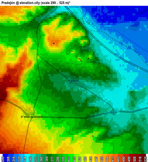
Below is the Elevation map of Pradejón, which displays elevation range with different colors. Scale of the first map is from 299 to 525 m (981 to 1722 ft) with average elevation of 387.4 meters (=1271 ft) [note 1]
These maps also provides idea of topography and contour of this city, they are displayed at different zoom levels. More info about maps, scale and edge coordinates you can find below images.
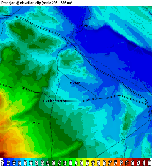
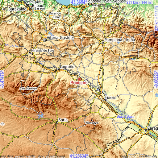
| \ | Map #1 | Map #2 | Topo.Map |
| Scale [m] | 299..525 m | 295..866 m | × |
| Scale [ft] | 981..1722 ft | 968..2841 ft | × |
| Average | 387.4 m = 1271 ft | 419.4 m = 1376 ft | × |
| Width | 7.22 km = 4.5 mi | 14.45 km = 9 mi | 231.2 km = 143.7 mi |
| Height | 7.22 km = 4.5 mi | 14.45 km = 9 mi | 231.2 km = 143.7 mi |
| ↑Max Latitude | 42.366937° | 42.399397° | 43.3654° |
| Latitude at center | 42.33446° | 42.33446° | 42.33446° |
| ↓Min Latitude | 42.301966° | 42.269455° | 41.28634° |
| ← Min Longitude | -2.112455° | -2.156401° | -3.47476° |
| Longitude center | -2.06851° | -2.06851° | -2.06851° |
| →Max Longitude | -2.024565° | -1.980619° | -0.66226° |
Nearby cities:
Cities around Pradejón sort by population:
• Calahorra elevation 352 m
9.1 km,  111°
111°
• Arnedo 531 m
12.1 km,  192°
192°
• San Adrián 301 m
11 km,  90°
90°
• Lodosa 321 m
9.8 km,  355°
355°
• Quel 483 m
11.7 km,  173°
173°
• Sartaguda 338 m
5.5 km,  9°
9°
• Cárcar 401 m
9.8 km,  48°
48°
• Ausejo 526 m
8.1 km,  275°
275°
• Alcanadre 348 m
8.9 km,  331°
331°
• Tudelilla 544 m
5.5 km,  226°
226°
• Bergasa 655 m
10.5 km,  210°
210°
• Andosilla 316 m
11.4 km,  65°
65°
Multilingual:
 En español:
Pradejón elevación 364 m.
 En France:
Pradejón élévation 364 m.
 Auf Deutsch:
Pradejón höhe über dem Meeresspiegel ist 364 m.

Sources and notes:
- [note 1] Map square and city borders are not equal. Map elevation data is calculated only from area inside that square.
- [src 1] Elevation data from geonames database provided with same terms of usage.
- [src 2] The elevation map of Pradejón is generated using elevation data from NASA's 3 arcsec (90m) resolution SRTM data.
- [src 3] Base (background) map © OpenStreetMap contributors tiles are generated by Geofabrik and OpenTopoMap.
Copyright & License:
This Pradejón Elevation Map is licensed under CC BY-SA. You may reuse any part from this page, if you give a proper credit by linking to this URL:
 More info on terms of use page.