Calahorra elevation
Calahorra (La Rioja, Provincia de La Rioja), Spain elevation is 352 meters and Calahorra elevation in feet is 1155 ft above sea level [src 1]. Calahorra is a seat of a third-order administrative division (feature code) with elevation that is 251 meters (823 ft) smaller than average city elevation in Spain.
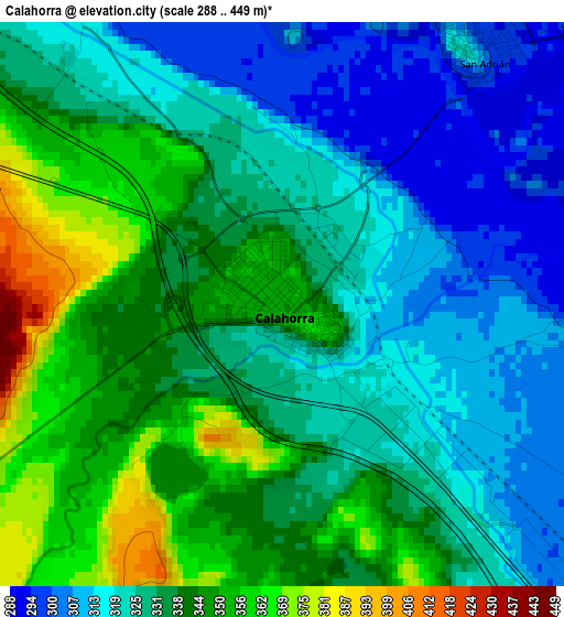
Below is the Elevation map of Calahorra, which displays elevation range with different colors. Scale of the first map is from 288 to 449 m (945 to 1473 ft) with average elevation of 332.3 meters (=1090 ft) [note 1]
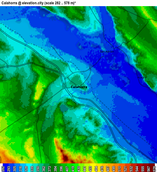
These maps also provides idea of topography and contour of this city, they are displayed at different zoom levels. More info about maps, scale and edge coordinates you can find below images.
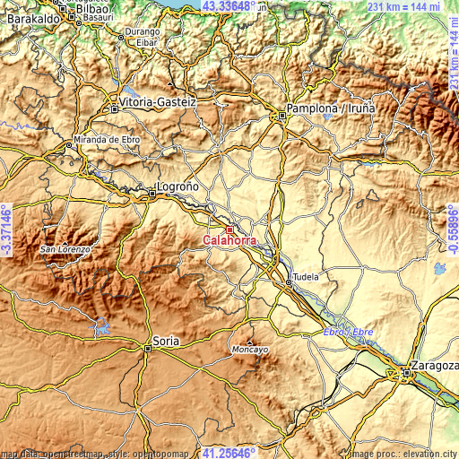
| \ | Map #1 | Map #2 | Topo.Map |
| Scale [m] | 288..449 m | 282..578 m | × |
| Scale [ft] | 945..1473 ft | 925..1896 ft | × |
| Average | 332.3 m = 1090 ft | 350.3 m = 1149 ft | × |
| Width | 7.23 km = 4.5 mi | 14.46 km = 9 mi | 231.3 km = 143.7 mi |
| Height | 7.23 km = 4.5 mi | 14.45 km = 9 mi | 231.3 km = 143.7 mi |
| ↑Max Latitude | 42.337552° | 42.370028° | 43.33648° |
| Latitude at center | 42.30506° | 42.30506° | 42.30506° |
| ↓Min Latitude | 42.272551° | 42.240025° | 41.25646° |
| ← Min Longitude | -2.009155° | -2.053101° | -3.37146° |
| Longitude center | -1.96521° | -1.96521° | -1.96521° |
| →Max Longitude | -1.921265° | -1.877319° | -0.55896° |
Nearby cities:
Cities around Calahorra sort by population:
• San Adrián elevation 301 m
4.1 km,  37°
37°
• Autol 434 m
10.4 km,  198°
198°
• Azagra 289 m
5.4 km,  95°
95°
• Pradejón 364 m
9.1 km,  291°
291°
• Rincón de Soto 291 m
12.2 km,  130°
130°
• Aldeanueva de Ebro 348 m
10.6 km,  142°
142°
• Funes 285 m
13.6 km,  85°
85°
• Quel 483 m
11 km,  220°
220°
• Sartaguda 338 m
11.5 km,  319°
319°
• Cárcar 401 m
9.9 km,  353°
353°
• Tudelilla 544 m
12.5 km,  267°
267°
• Andosilla 316 m
8.2 km,  12°
12°
Multilingual:
 En español:
Calahorra elevación 352 m.
 En France:
Calahorra élévation 352 m.
 Auf Deutsch:
Calahorra höhe über dem Meeresspiegel ist 352 m.

Sources and notes:
- [note 1] Map square and city borders are not equal. Map elevation data is calculated only from area inside that square.
- [src 1] Elevation data from geonames database provided with same terms of usage.
- [src 2] The elevation map of Calahorra is generated using elevation data from NASA's 3 arcsec (90m) resolution SRTM data.
- [src 3] Base (background) map © OpenStreetMap contributors tiles are generated by Geofabrik and OpenTopoMap.
Copyright & License:
This Calahorra Elevation Map is licensed under CC BY-SA. You may reuse any part from this page, if you give a proper credit by linking to this URL:
 More info on terms of use page.