Arnedo elevation
Arnedo (La Rioja, Provincia de La Rioja), Spain elevation is 531 meters and Arnedo elevation in feet is 1742 ft above sea level [src 1]. Arnedo is a populated place (feature code) with elevation that is 72 meters (236 ft) smaller than average city elevation in Spain.
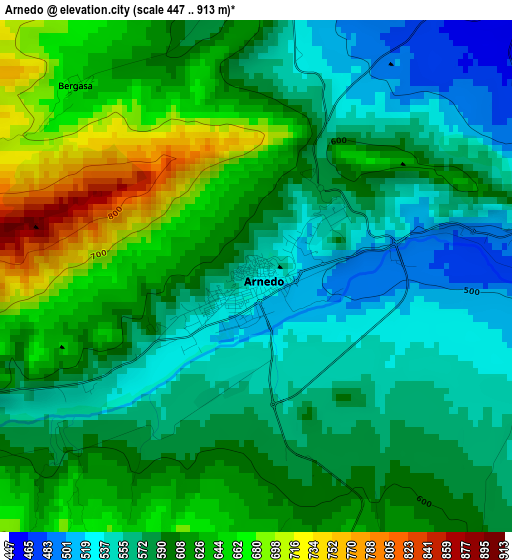
Below is the Elevation map of Arnedo, which displays elevation range with different colors. Scale of the first map is from 447 to 913 m (1467 to 2995 ft) with average elevation of 598.5 meters (=1964 ft) [note 1]
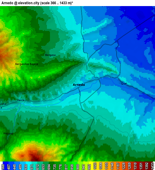
These maps also provides idea of topography and contour of this city, they are displayed at different zoom levels. More info about maps, scale and edge coordinates you can find below images.
| \ | Map #1 | Map #2 | Topo.Map |
| Scale [m] | 447..913 m | 366..1433 m | × |
| Scale [ft] | 1467..2995 ft | 1201..4701 ft | × |
| Average | 598.5 m = 1964 ft | 646.3 m = 2120 ft | × |
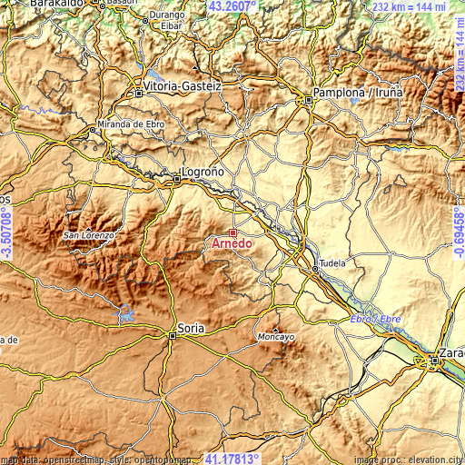
| Width | 7.24 km = 4.5 mi | 14.47 km = 9 mi | 231.6 km = 143.9 mi |
| Height | 7.24 km = 4.5 mi | 14.47 km = 9 mi | 231.6 km = 143.9 mi |
| ↑Max Latitude | 42.260532° | 42.293047° | 43.2607° |
| Latitude at center | 42.228° | 42.228° | 42.228° |
| ↓Min Latitude | 42.195451° | 42.162886° | 41.17813° |
| ← Min Longitude | -2.144775° | -2.188721° | -3.50708° |
| Longitude center | -2.10083° | -2.10083° | -2.10083° |
| →Max Longitude | -2.056885° | -2.012939° | -0.69458° |
Nearby cities:
Cities around Arnedo sort by population:
• Autol elevation 434 m
8 km,  99°
99°
• Pradejón 364 m
12.1 km,  12°
12°
• Quel 483 m
4 km,  87°
87°
• Arnedillo 672 m
11.3 km,  261°
261°
• Tudelilla 544 m
8.1 km,  350°
350°
• Herce 589 m
5.5 km,  253°
253°
• Préjano 710 m
8 km,  234°
234°
• Bergasa 655 m
3.8 km,  316°
316°
• Santa Eulalia Bajera 620 m
7.8 km, 254°
• Muro de Aguas 893 m
10.5 km,  184°
184°
• Bergasillas Bajera 834 m
5.1 km,  291°
291°
• Villarroya 925 m
11.2 km,  166°
166°
Multilingual:
 En español:
Arnedo elevación 531 m.
 En France:
Arnedo élévation 531 m.


Sources and notes:
- [note 1] Map square and city borders are not equal. Map elevation data is calculated only from area inside that square.
- [src 1] Elevation data from geonames database provided with same terms of usage.
- [src 2] The elevation map of Arnedo is generated using elevation data from NASA's 3 arcsec (90m) resolution SRTM data.
- [src 3] Base (background) map © OpenStreetMap contributors tiles are generated by Geofabrik and OpenTopoMap.
Copyright & License:
This Arnedo Elevation Map is licensed under CC BY-SA. You may reuse any part from this page, if you give a proper credit by linking to this URL:
 More info on terms of use page.