Peralta elevation
Peralta (Navarre, Provincia de Navarra), Spain elevation is 290 meters and Peralta elevation in feet is 951 ft above sea level [src 1]. Peralta is a seat of a third-order administrative division (feature code) with elevation that is 313 meters (1027 ft) smaller than average city elevation in Spain.
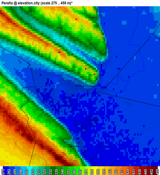
Below is the Elevation map of Peralta, which displays elevation range with different colors. Scale of the first map is from 275 to 459 m (902 to 1506 ft) with average elevation of 321.8 meters (=1056 ft) [note 1]
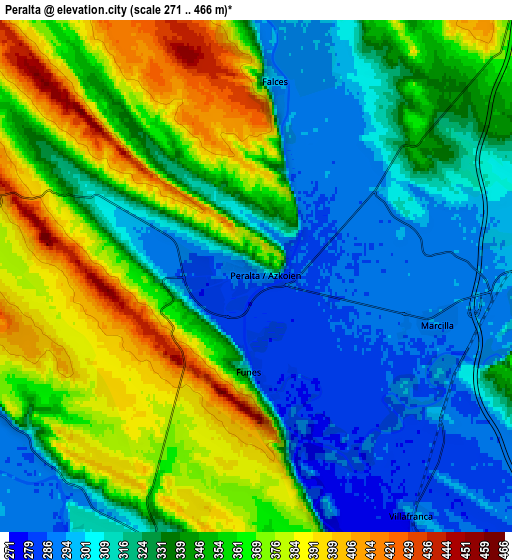
These maps also provides idea of topography and contour of this city, they are displayed at different zoom levels. More info about maps, scale and edge coordinates you can find below images.

| \ | Map #1 | Map #2 | Topo.Map |
| Scale [m] | 275..459 m | 271..466 m | × |
| Scale [ft] | 902..1506 ft | 889..1529 ft | × |
| Average | 321.8 m = 1056 ft | 338.3 m = 1110 ft | × |
| Width | 7.22 km = 4.5 mi | 14.45 km = 9 mi | 231.2 km = 143.7 mi |
| Height | 7.22 km = 4.5 mi | 14.45 km = 9 mi | 231.1 km = 143.6 mi |
| ↑Max Latitude | 42.370815° | 42.403273° | 43.36921° |
| Latitude at center | 42.33834° | 42.33834° | 42.33834° |
| ↓Min Latitude | 42.305848° | 42.273339° | 41.29029° |
| ← Min Longitude | -1.844295° | -1.888241° | -3.2066° |
| Longitude center | -1.80035° | -1.80035° | -1.80035° |
| →Max Longitude | -1.756405° | -1.712459° | -0.3941° |
Nearby cities:
Cities around Peralta sort by population:
• Calahorra elevation 352 m
14 km,  254°
254°
• San Adrián 301 m
11.1 km,  267°
267°
• Azagra 289 m
9.2 km,  242°
242°
• Rincón de Soto 291 m
12.3 km,  200°
200°
• Milagro 295 m
11.1 km,  165°
165°
• Andosilla 333 m
11.5 km,  65°
65°
• Villafranca 288 m
7.9 km,  145°
145°
• Marcilla 293 m
5.3 km,  102°
102°
• Falces 291 m
5.7 km,  5°
5°
• Caparroso 303 m
12.4 km,  88°
88°
• Funes 285 m
2.5 km,  179°
179°
• Andosilla 316 m
12.5 km,  290°
290°
Multilingual:
 En español:
Peralta elevación 290 m.
 En France:
Peralta élévation 290 m.


Sources and notes:
- [note 1] Map square and city borders are not equal. Map elevation data is calculated only from area inside that square.
- [src 1] Elevation data from geonames database provided with same terms of usage.
- [src 2] The elevation map of Peralta is generated using elevation data from NASA's 3 arcsec (90m) resolution SRTM data.
- [src 3] Base (background) map © OpenStreetMap contributors tiles are generated by Geofabrik and OpenTopoMap.
Copyright & License:
This Peralta Elevation Map is licensed under CC BY-SA. You may reuse any part from this page, if you give a proper credit by linking to this URL:
 More info on terms of use page.