Lerín elevation
Lerín (Navarre, Provincia de Navarra), Spain elevation is 442 meters and Lerín elevation in feet is 1450 ft above sea level [src 1]. Lerín is a seat of a third-order administrative division (feature code) with elevation that is 161 meters (528 ft) smaller than average city elevation in Spain.
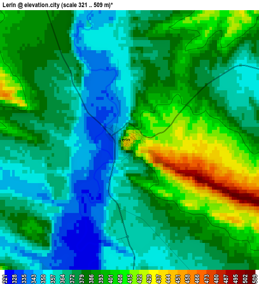
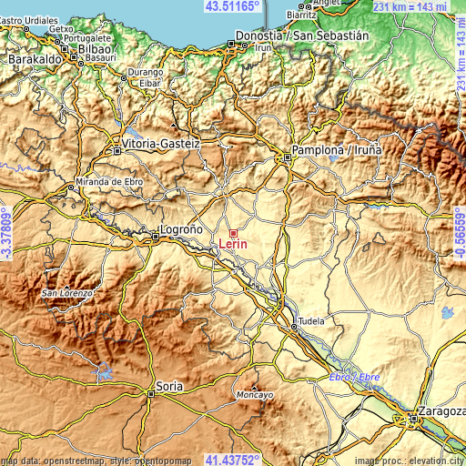
Below is the Elevation map of Lerín, which displays elevation range with different colors. Scale of the first map is from 321 to 509 m (1053 to 1670 ft) with average elevation of 379.9 meters (=1246 ft) [note 1]
These maps also provides idea of topography and contour of this city, they are displayed at different zoom levels. More info about maps, scale and edge coordinates you can find below images.
| \ | Map #1 | Topo.Map |
| Scale [m] | 321..509 m | × |
| Scale [ft] | 1053..1670 ft | × |
| Average | 379.9 m = 1246 ft | × |
| Width | 7.21 km = 4.5 mi | 230.6 km = 143.3 mi |
| Height | 7.21 km = 4.5 mi | 230.6 km = 143.3 mi |
| ↑Max Latitude | 42.51558° | 43.51165° |
| Latitude at center | 42.48318° | 42.48318° |
| ↓Min Latitude | 42.450763° | 41.43752° |
| ← Min Longitude | -2.015785° | -3.37809° |
| Longitude center | -1.97184° | -1.97184° |
| →Max Longitude | -1.927895° | -0.56559° |
Nearby cities:
Cities around Lerín sort by population:
• Lodosa elevation 321 m
11 km,  232°
232°
• Larraga 392 m
13.1 km,  50°
50°
• Sesma 431 m
9.2 km,  266°
266°
• Sartaguda 338 m
13.1 km,  212°
212°
• Allo 425 m
10.2 km,  336°
336°
• Cárcar 401 m
10 km,  183°
183°
• Miranda de Arga 317 m
11.8 km,  89°
89°
• Alcanadre 348 m
15 km, 234°
• Berbinzana 320 m
12.3 km,  66°
66°
• Dicastillo 532 m
13.4 km, 340°
• Morentin 537 m
14.8 km,  346°
346°
• Andosilla 316 m
12 km,  168°
168°
Multilingual:
 En español:
Lerín elevación 442 m.
 En France:
Lerín élévation 442 m.


Sources and notes:
- [note 1] Map square and city borders are not equal. Map elevation data is calculated only from area inside that square.
- [src 1] Elevation data from geonames database provided with same terms of usage.
- [src 2] The elevation map of Lerín is generated using elevation data from NASA's 3 arcsec (90m) resolution SRTM data.
- [src 3] Base (background) map © OpenStreetMap contributors tiles are generated by Geofabrik and OpenTopoMap.
Copyright & License:
This Lerín Elevation Map is licensed under CC BY-SA. You may reuse any part from this page, if you give a proper credit by linking to this URL:
 More info on terms of use page.