Larraga elevation
Larraga (Navarre, Provincia de Navarra), Spain elevation is 392 meters and Larraga elevation in feet is 1286 ft above sea level [src 1]. Larraga is a seat of a third-order administrative division (feature code) with elevation that is 211 meters (692 ft) smaller than average city elevation in Spain.
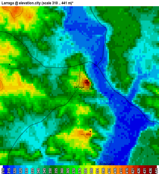
Below is the Elevation map of Larraga, which displays elevation range with different colors. Scale of the first map is from 310 to 441 m (1017 to 1447 ft) with average elevation of 348.9 meters (=1145 ft) [note 1]
These maps also provides idea of topography and contour of this city, they are displayed at different zoom levels. More info about maps, scale and edge coordinates you can find below images.
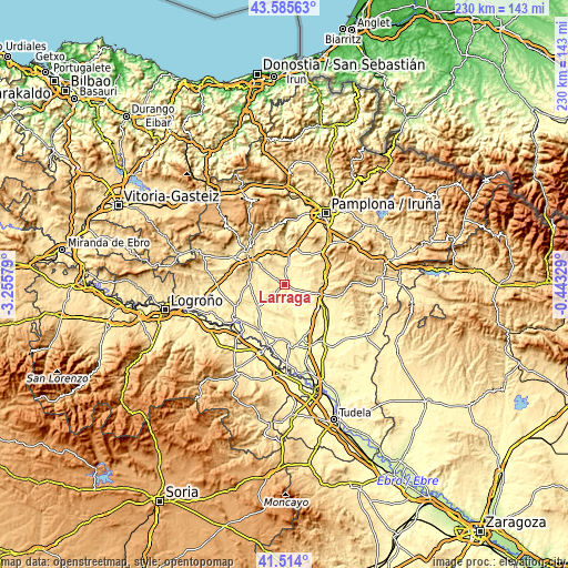
| \ | Map #1 | Topo.Map |
| Scale [m] | 310..441 m | × |
| Scale [ft] | 1017..1447 ft | × |
| Average | 348.9 m = 1145 ft | × |
| Width | 7.2 km = 4.5 mi | 230.3 km = 143.1 mi |
| Height | 7.2 km = 4.5 mi | 230.3 km = 143.1 mi |
| ↑Max Latitude | 42.590771° | 43.58563° |
| Latitude at center | 42.55841° | 42.55841° |
| ↓Min Latitude | 42.526032° | 41.514° |
| ← Min Longitude | -1.893485° | -3.25579° |
| Longitude center | -1.84954° | -1.84954° |
| →Max Longitude | -1.805595° | -0.44329° |
Nearby cities:
Cities around Larraga sort by population:
• Tafalla elevation 424 m
14.8 km,  103°
103°
• Puente la Reina 352 m
13.1 km,  12°
12°
• Lerín 442 m
13.1 km,  230°
230°
• Artajona 410 m
7.7 km,  64°
64°
• Allo 425 m
14 km,  274°
274°
• Mendigorría 395 m
7.9 km, 9°
• Miranda de Arga 317 m
8.5 km,  167°
167°
• Obanos 416 m
14.6 km,  21°
21°
• Berbinzana 320 m
3.6 km,  159°
159°
• Cirauqui 491 m
13.5 km,  345°
345°
• Mañeru 460 m
12.5 km, 354°
• Oteiza 510 m
10.9 km,  308°
308°
Multilingual:
 En español:
Larraga elevación 392 m.
 En France:
Larraga élévation 392 m.


Sources and notes:
- [note 1] Map square and city borders are not equal. Map elevation data is calculated only from area inside that square.
- [src 1] Elevation data from geonames database provided with same terms of usage.
- [src 2] The elevation map of Larraga is generated using elevation data from NASA's 3 arcsec (90m) resolution SRTM data.
- [src 3] Base (background) map © OpenStreetMap contributors tiles are generated by Geofabrik and OpenTopoMap.
Copyright & License:
This Larraga Elevation Map is licensed under CC BY-SA. You may reuse any part from this page, if you give a proper credit by linking to this URL:
 More info on terms of use page.