Miranda de Arga elevation
Miranda de Arga (Navarre, Provincia de Navarra), Spain elevation is 317 meters and Miranda de Arga elevation in feet is 1040 ft above sea level [src 1]. Miranda de Arga is a seat of a third-order administrative division (feature code) with elevation that is 286 meters (938 ft) smaller than average city elevation in Spain.
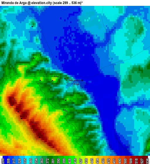
Below is the Elevation map of Miranda de Arga, which displays elevation range with different colors. Scale of the first map is from 299 to 536 m (981 to 1759 ft) with average elevation of 361.3 meters (=1185 ft) [note 1]
These maps also provides idea of topography and contour of this city, they are displayed at different zoom levels. More info about maps, scale and edge coordinates you can find below images.
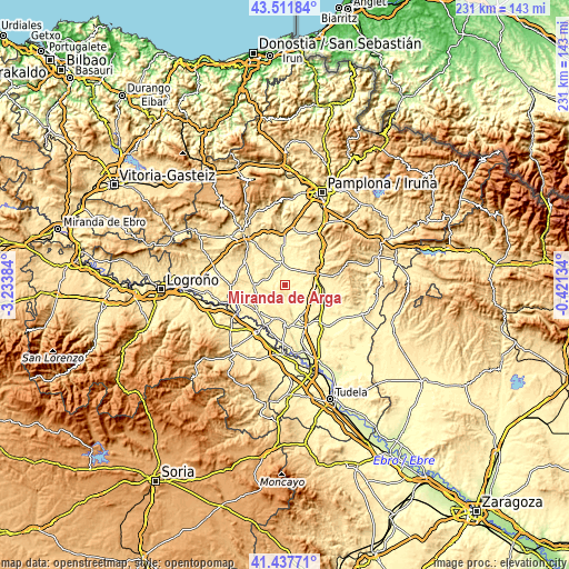
| \ | Map #1 | Topo.Map |
| Scale [m] | 299..536 m | × |
| Scale [ft] | 981..1759 ft | × |
| Average | 361.3 m = 1185 ft | × |
| Width | 7.21 km = 4.5 mi | 230.6 km = 143.3 mi |
| Height | 7.21 km = 4.5 mi | 230.6 km = 143.3 mi |
| ↑Max Latitude | 42.51577° | 43.51184° |
| Latitude at center | 42.48337° | 42.48337° |
| ↓Min Latitude | 42.450953° | 41.43771° |
| ← Min Longitude | -1.871535° | -3.23384° |
| Longitude center | -1.82759° | -1.82759° |
| →Max Longitude | -1.783645° | -0.42134° |
Nearby cities:
Cities around Miranda de Arga sort by population:
• Tafalla elevation 424 m
13.5 km,  68°
68°
• Peralta 290 m
16.3 km,  172°
172°
• Olite 394 m
14.4 km,  91°
91°
• Andosilla 333 m
17 km,  131°
131°
• Falces 291 m
10.8 km,  164°
164°
• Larraga 392 m
8.5 km,  347°
347°
• Lerín 442 m
11.8 km,  269°
269°
• Artajona 410 m
12.8 km,  23°
23°
• Cárcar 401 m
16 km,  231°
231°
• Mendigorría 395 m
16.1 km,  357°
357°
• Berbinzana 320 m
5 km, 353°
• Andosilla 316 m
15.1 km,  218°
218°
Multilingual:
 En español:
Miranda de Arga elevación 317 m.
 En France:
Miranda de Arga élévation 317 m.
 Auf Deutsch:
Miranda de Arga höhe über dem Meeresspiegel ist 317 m.

Sources and notes:
- [note 1] Map square and city borders are not equal. Map elevation data is calculated only from area inside that square.
- [src 1] Elevation data from geonames database provided with same terms of usage.
- [src 2] The elevation map of Miranda de Arga is generated using elevation data from NASA's 3 arcsec (90m) resolution SRTM data.
- [src 3] Base (background) map © OpenStreetMap contributors tiles are generated by Geofabrik and OpenTopoMap.
Copyright & License:
This Miranda de Arga Elevation Map is licensed under CC BY-SA. You may reuse any part from this page, if you give a proper credit by linking to this URL:
 More info on terms of use page.