Totana elevation
Totana (Murcia), Spain elevation is 262 meters and Totana elevation in feet is 860 ft above sea level [src 1]. Totana is a seat of a third-order administrative division (feature code) with elevation that is 341 meters (1119 ft) smaller than average city elevation in Spain.
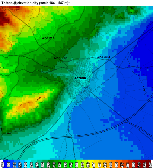
Below is the Elevation map of Totana, which displays elevation range with different colors. Scale of the first map is from 184 to 547 m (604 to 1795 ft) with average elevation of 276 meters (=906 ft) [note 1]
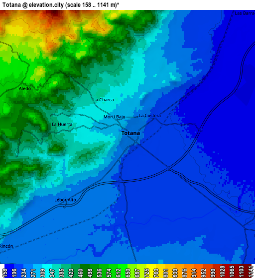
These maps also provides idea of topography and contour of this city, they are displayed at different zoom levels. More info about maps, scale and edge coordinates you can find below images.

| \ | Map #1 | Map #2 | Topo.Map |
| Scale [m] | 184..547 m | 158..1141 m | × |
| Scale [ft] | 604..1795 ft | 518..3743 ft | × |
| Average | 276 m = 906 ft | 325.6 m = 1068 ft | × |
| Width | 7.73 km = 4.8 mi | 15.45 km = 9.6 mi | 247.2 km = 153.6 mi |
| Height | 7.73 km = 4.8 mi | 15.45 km = 9.6 mi | 247.2 km = 153.6 mi |
| ↑Max Latitude | 37.80353° | 37.838244° | 38.87204° |
| Latitude at center | 37.7688° | 37.7688° | 37.7688° |
| ↓Min Latitude | 37.734054° | 37.699291° | 36.64885° |
| ← Min Longitude | -1.546235° | -1.590181° | -2.90854° |
| Longitude center | -1.50229° | -1.50229° | -1.50229° |
| →Max Longitude | -1.458345° | -1.414399° | -0.09604° |
Nearby cities:
Cities around Totana sort by population:
• Lorca elevation 339 m
20.6 km,  238°
238°
• Mazarrón 66 m
25 km,  138°
138°
• Alhama de Murcia 201 m
11.4 km,  36°
36°
• Mula 308 m
30.3 km,  2°
2°
• Sangonera la Verde 85 m
31.4 km,  55°
55°
• Fuente-Álamo de Murcia 117 m
29.7 km,  99°
99°
• Librilla 175 m
18.4 km, 44°
• Pliego 402 m
24.5 km,  359°
359°
• Campos del Río 182 m
32.8 km,  23°
23°
• La Torrecilla 295 m
25.6 km,  230°
230°
• Albudeite 178 m
30.7 km, 19°
• Aledo 612 m
6.8 km,  293°
293°
Multilingual:
 En español:
Totana elevación 262 m.
 En France:
Totana élévation 262 m.


Sources and notes:
- [note 1] Map square and city borders are not equal. Map elevation data is calculated only from area inside that square.
- [src 1] Elevation data from geonames database provided with same terms of usage.
- [src 2] The elevation map of Totana is generated using elevation data from NASA's 3 arcsec (90m) resolution SRTM data.
- [src 3] Base (background) map © OpenStreetMap contributors tiles are generated by Geofabrik and OpenTopoMap.
Copyright & License:
This Totana Elevation Map is licensed under CC BY-SA. You may reuse any part from this page, if you give a proper credit by linking to this URL:
 More info on terms of use page.