La Torrecilla elevation
La Torrecilla (Murcia), Spain elevation is 295 meters and La Torrecilla elevation in feet is 968 ft above sea level [src 1]. La Torrecilla is a populated place (feature code) with elevation that is 308 meters (1010 ft) smaller than average city elevation in Spain.
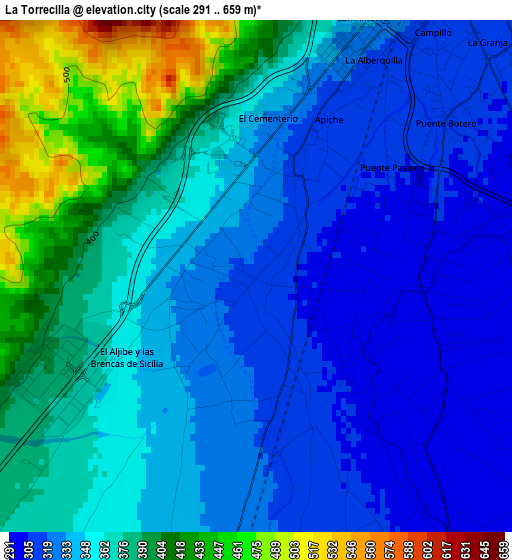
Below is the Elevation map of La Torrecilla, which displays elevation range with different colors. Scale of the first map is from 291 to 659 m (955 to 2162 ft) with average elevation of 355.7 meters (=1167 ft) [note 1]
These maps also provides idea of topography and contour of this city, they are displayed at different zoom levels. More info about maps, scale and edge coordinates you can find below images.
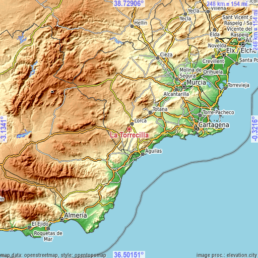
| \ | Map #1 | Topo.Map |
| Scale [m] | 291..659 m | × |
| Scale [ft] | 955..2162 ft | × |
| Average | 355.7 m = 1167 ft | × |
| Width | 7.74 km = 4.8 mi | 247.7 km = 153.9 mi |
| Height | 7.74 km = 4.8 mi | 247.7 km = 153.9 mi |
| ↑Max Latitude | 37.658428° | 38.72906° |
| Latitude at center | 37.62363° | 37.62363° |
| ↓Min Latitude | 37.588815° | 36.50151° |
| ← Min Longitude | -1.771795° | -3.1341° |
| Longitude center | -1.72785° | -1.72785° |
| →Max Longitude | -1.683905° | -0.3216° |
Nearby cities:
Cities around La Torrecilla sort by population:
• Lorca elevation 339 m
5.8 km,  23°
23°
• Mazarrón 66 m
36.5 km,  94°
94°
• Águilas 23 m
27.3 km,  152°
152°
• Totana 262 m
25.6 km,  50°
50°
• Alhama de Murcia 201 m
36.7 km, 46°
• Huércal-Overa 286 m
32.2 km,  216°
216°
• Puerto Lumbreras 475 m
9.9 km,  227°
227°
• Pulpí 196 m
23.6 km,  183°
183°
• Velez Rubio 828 m
30.9 km,  275°
275°
• Vélez-Blanco 1073 m
33.3 km, 283°
• Aledo 612 m
23.3 km,  35°
35°
• Taberno 713 m
35.3 km,  240°
240°
Multilingual:
 En español:
La Torrecilla elevación 295 m.
 En France:
La Torrecilla élévation 295 m.
 Auf Deutsch:
La Torrecilla höhe über dem Meeresspiegel ist 295 m.

Sources and notes:
- [note 1] Map square and city borders are not equal. Map elevation data is calculated only from area inside that square.
- [src 1] Elevation data from geonames database provided with same terms of usage.
- [src 2] The elevation map of La Torrecilla is generated using elevation data from NASA's 3 arcsec (90m) resolution SRTM data.
- [src 3] Base (background) map © OpenStreetMap contributors tiles are generated by Geofabrik and OpenTopoMap.
Copyright & License:
This La Torrecilla Elevation Map is licensed under CC BY-SA. You may reuse any part from this page, if you give a proper credit by linking to this URL:
 More info on terms of use page.