Mazarrón elevation
Mazarrón (Murcia), Spain elevation is 66 meters and Mazarrón elevation in feet is 217 ft above sea level [src 1]. Mazarrón is a seat of a third-order administrative division (feature code) with elevation that is 537 meters (1762 ft) smaller than average city elevation in Spain.
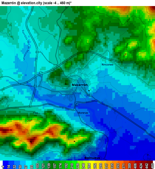
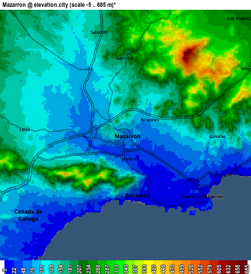
Below is the Elevation map of Mazarrón, which displays elevation range with different colors. Scale of the first map is from -4 to 460 m (-13 to 1509 ft) with average elevation of 108.2 meters (=355 ft) [note 1]
These maps also provides idea of topography and contour of this city, they are displayed at different zoom levels. More info about maps, scale and edge coordinates you can find below images.
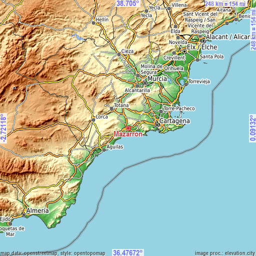
| \ | Map #1 | Map #2 | Topo.Map |
| Scale [m] | -4..460 m | -5..685 m | × |
| Scale [ft] | -13..1509 ft | -16..2247 ft | × |
| Average | 108.2 m = 355 ft | 154.3 m = 506 ft | × |
| Width | 7.74 km = 4.8 mi | 15.49 km = 9.6 mi | 247.8 km = 154 mi |
| Height | 7.74 km = 4.8 mi | 15.49 km = 9.6 mi | 247.8 km = 154 mi |
| ↑Max Latitude | 37.63401° | 37.668803° | 38.705° |
| Latitude at center | 37.5992° | 37.5992° | 37.5992° |
| ↓Min Latitude | 37.564374° | 37.529532° | 36.47672° |
| ← Min Longitude | -1.358875° | -1.402821° | -2.72118° |
| Longitude center | -1.31493° | -1.31493° | -1.31493° |
| →Max Longitude | -1.270985° | -1.227039° | 0.09132° |
Nearby cities:
Cities around Mazarrón sort by population:
• Cartagena elevation 5 m
29 km,  88°
88°
• Lorca 339 m
35 km,  283°
283°
• Águilas 23 m
31.9 km,  227°
227°
• Totana 262 m
25 km,  318°
318°
• Alhama de Murcia 201 m
29.6 km,  340°
340°
• Fuente-Álamo de Murcia 117 m
18.9 km,  42°
42°
• El Plan 49 m
26.9 km,  77°
77°
• Los Gabatos 23 m
28 km, 82°
• Barrio de la Concepción 54 m
27.7 km, 89°
• Librilla 175 m
32.1 km,  353°
353°
• Los Martínez 165 m
32 km, 40°
• Aledo 612 m
31.4 km,  313°
313°
Multilingual:
 En español:
Mazarrón elevación 66 m.
 En France:
Mazarrón élévation 66 m.


Sources and notes:
- [note 1] Map square and city borders are not equal. Map elevation data is calculated only from area inside that square.
- [src 1] Elevation data from geonames database provided with same terms of usage.
- [src 2] The elevation map of Mazarrón is generated using elevation data from NASA's 3 arcsec (90m) resolution SRTM data.
- [src 3] Base (background) map © OpenStreetMap contributors tiles are generated by Geofabrik and OpenTopoMap.
Copyright & License:
This Mazarrón Elevation Map is licensed under CC BY-SA. You may reuse any part from this page, if you give a proper credit by linking to this URL:
 More info on terms of use page.