Los Martínez elevation
Los Martínez (Murcia), Spain elevation is 165 meters and Los Martínez elevation in feet is 541 ft above sea level [src 1]. Los Martínez is a populated place (feature code) with elevation that is 438 meters (1437 ft) smaller than average city elevation in Spain.
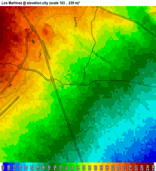
Below is the Elevation map of Los Martínez, which displays elevation range with different colors. Scale of the first map is from 103 to 239 m (338 to 784 ft) with average elevation of 166.8 meters (=547 ft) [note 1]
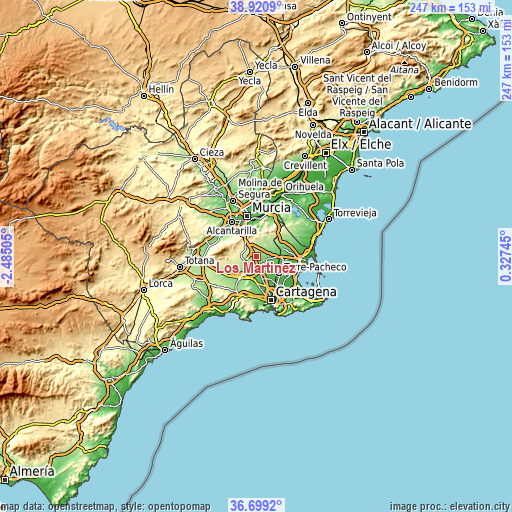
These maps also provides idea of topography and contour of this city, they are displayed at different zoom levels. More info about maps, scale and edge coordinates you can find below images.
| \ | Map #1 | Topo.Map |
| Scale [m] | 103..239 m | × |
| Scale [ft] | 338..784 ft | × |
| Average | 166.8 m = 547 ft | × |
| Width | 7.72 km = 4.8 mi | 247 km = 153.5 mi |
| Height | 7.72 km = 4.8 mi | 247 km = 153.5 mi |
| ↑Max Latitude | 37.853117° | 38.9209° |
| Latitude at center | 37.81841° | 37.81841° |
| ↓Min Latitude | 37.783687° | 36.6992° |
| ← Min Longitude | -1.122745° | -2.48505° |
| Longitude center | -1.0788° | -1.0788° |
| →Max Longitude | -1.034855° | 0.32745° |
Nearby cities:
Cities around Los Martínez sort by population:
• Murcia elevation 53 m
19.3 km,  346°
346°
• Alcantarilla 76 m
20.7 km,  324°
324°
• Torre-Pacheco 43 m
13.8 km,  127°
127°
• San Javier 27 m
21.3 km,  93°
93°
• Los Alcázares 4 m
21.7 km,  112°
112°
• Sangonera la Verde 85 m
16.7 km, 317°
• Fuente-Álamo de Murcia 117 m
13.2 km,  217°
217°
• Santiago de la Ribera 7 m
24.1 km,  95°
95°
• El Plan 49 m
19.5 km,  163°
163°
• Esparragal 44 m
23.9 km,  359°
359°
• Los Gabatos 23 m
21.7 km, 161°
• Santa Cruz 30 m
22.7 km,  4°
4°
Multilingual:
 En español:
Los Martínez elevación 165 m.
 En France:
Los Martínez élévation 165 m.
 Auf Deutsch:
Los Martínez höhe über dem Meeresspiegel ist 165 m.

Sources and notes:
- [note 1] Map square and city borders are not equal. Map elevation data is calculated only from area inside that square.
- [src 1] Elevation data from geonames database provided with same terms of usage.
- [src 2] The elevation map of Los Martínez is generated using elevation data from NASA's 3 arcsec (90m) resolution SRTM data.
- [src 3] Base (background) map © OpenStreetMap contributors tiles are generated by Geofabrik and OpenTopoMap.
Copyright & License:
This Los Martínez Elevation Map is licensed under CC BY-SA. You may reuse any part from this page, if you give a proper credit by linking to this URL:
 More info on terms of use page.