Sangonera la Verde elevation
Sangonera la Verde (Murcia), Spain elevation is 85 meters and Sangonera la Verde elevation in feet is 279 ft above sea level [src 1]. Sangonera la Verde is a populated place (feature code) with elevation that is 518 meters (1699 ft) smaller than average city elevation in Spain.
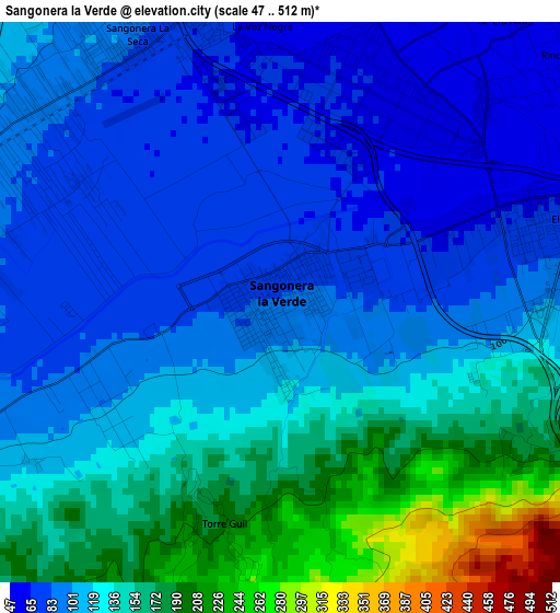
Below is the Elevation map of Sangonera la Verde, which displays elevation range with different colors. Scale of the first map is from 47 to 512 m (154 to 1680 ft) with average elevation of 120.6 meters (=396 ft) [note 1]
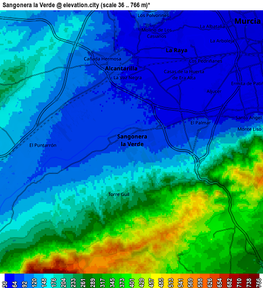
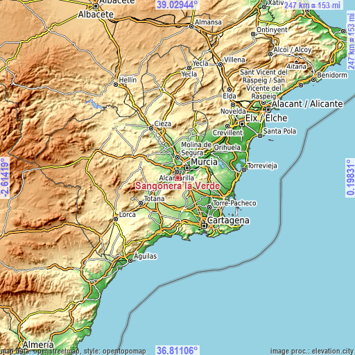
These maps also provides idea of topography and contour of this city, they are displayed at different zoom levels. More info about maps, scale and edge coordinates you can find below images.
| \ | Map #1 | Map #2 | Topo.Map |
| Scale [m] | 47..512 m | 36..766 m | × |
| Scale [ft] | 154..1680 ft | 118..2513 ft | × |
| Average | 120.6 m = 396 ft | 188.9 m = 620 ft | × |
| Width | 7.71 km = 4.8 mi | 15.42 km = 9.6 mi | 246.7 km = 153.3 mi |
| Height | 7.71 km = 4.8 mi | 15.42 km = 9.6 mi | 246.7 km = 153.3 mi |
| ↑Max Latitude | 37.963275° | 37.997913° | 39.02944° |
| Latitude at center | 37.92862° | 37.92862° | 37.92862° |
| ↓Min Latitude | 37.893949° | 37.859261° | 36.81106° |
| ← Min Longitude | -1.251885° | -1.295831° | -2.61419° |
| Longitude center | -1.20794° | -1.20794° | -1.20794° |
| →Max Longitude | -1.163995° | -1.120049° | 0.19831° |
Nearby cities:
Cities around Sangonera la Verde sort by population:
• Murcia elevation 53 m
9.4 km,  46°
46°
• Molina de Segura 108 m
14 km,  0°
0°
• Alcantarilla 76 m
4.6 km,  349°
349°
• Las Torres de Cotillas 87 m
11.5 km,  344°
344°
• Ceuti 95 m
17.7 km, 340°
• Alguazas 100 m
14.4 km, 344°
• Esparragal 44 m
16 km,  43°
43°
• Lorquí 114 m
17.5 km, 347°
• Librilla 175 m
13.8 km,  250°
250°
• Santa Cruz 30 m
16.8 km, 51°
• Campos del Río 182 m
17.7 km,  314°
314°
• Los Martínez 165 m
16.7 km,  137°
137°
Multilingual:
 En español:
Sangonera la Verde elevación 85 m.
 En France:
Sangonera la Verde élévation 85 m.
 Auf Deutsch:
Sangonera la Verde höhe über dem Meeresspiegel ist 85 m.

Sources and notes:
- [note 1] Map square and city borders are not equal. Map elevation data is calculated only from area inside that square.
- [src 1] Elevation data from geonames database provided with same terms of usage.
- [src 2] The elevation map of Sangonera la Verde is generated using elevation data from NASA's 3 arcsec (90m) resolution SRTM data.
- [src 3] Base (background) map © OpenStreetMap contributors tiles are generated by Geofabrik and OpenTopoMap.
Copyright & License:
This Sangonera la Verde Elevation Map is licensed under CC BY-SA. You may reuse any part from this page, if you give a proper credit by linking to this URL:
 More info on terms of use page.