Águilas elevation
Águilas (Murcia), Spain elevation is 23 meters and Águilas elevation in feet is 75 ft above sea level [src 1]. Águilas is a seat of a third-order administrative division (feature code) with elevation that is 580 meters (1903 ft) smaller than average city elevation in Spain.
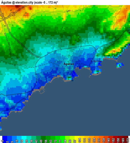
Below is the Elevation map of Águilas, which displays elevation range with different colors. Scale of the first map is from -5 to 172 m (-16 to 564 ft) with average elevation of 52.1 meters (=171 ft) [note 1]
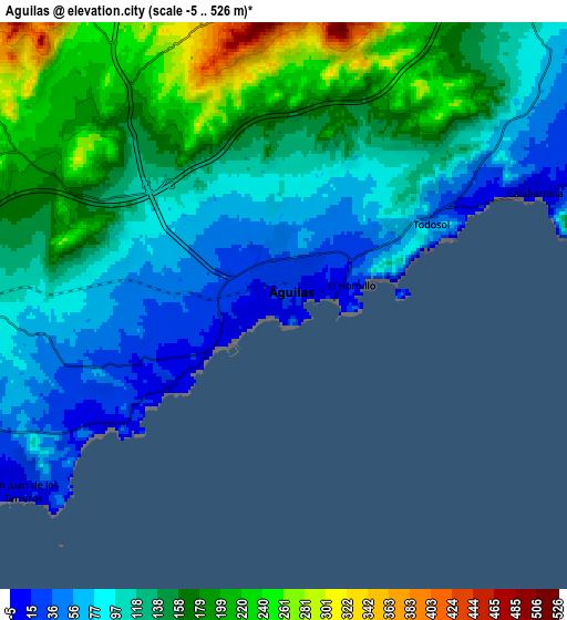
These maps also provides idea of topography and contour of this city, they are displayed at different zoom levels. More info about maps, scale and edge coordinates you can find below images.
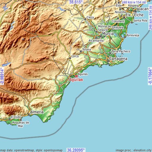
| \ | Map #1 | Map #2 | Topo.Map |
| Scale [m] | -5..172 m | -5..526 m | × |
| Scale [ft] | -16..564 ft | -16..1726 ft | × |
| Average | 52.1 m = 171 ft | 131.5 m = 431 ft | × |
| Width | 7.76 km = 4.8 mi | 15.53 km = 9.6 mi | 248.4 km = 154.3 mi |
| Height | 7.76 km = 4.8 mi | 15.53 km = 9.6 mi | 248.4 km = 154.3 mi |
| ↑Max Latitude | 37.4412° | 37.476083° | 38.515° |
| Latitude at center | 37.4063° | 37.4063° | 37.4063° |
| ↓Min Latitude | 37.371384° | 37.336452° | 36.28095° |
| ← Min Longitude | -1.626835° | -1.670781° | -2.98914° |
| Longitude center | -1.58289° | -1.58289° | -1.58289° |
| →Max Longitude | -1.538945° | -1.494999° | -0.17664° |
Nearby cities:
Cities around Águilas sort by population:
• Lorca elevation 339 m
31.3 km,  340°
340°
• Mazarrón 66 m
31.9 km,  47°
47°
• Huércal-Overa 286 m
31.9 km,  266°
266°
• Vera 75 m
30.4 km,  233°
233°
• Puerto Lumbreras 475 m
26.6 km,  311°
311°
• Cuevas del Almanzora 46 m
29.1 km,  245°
245°
• Pulpí 196 m
14.3 km, 272°
• Garrucha 16 m
32.8 km,  220°
220°
• Mojacar 162 m
37.9 km, 218°
• Antas 108 m
34.6 km,  238°
238°
• Turre 50 m
39.5 km, 224°
• La Torrecilla 295 m
27.3 km,  332°
332°
Multilingual:
 En español:
Águilas elevación 23 m.
 En France:
Águilas élévation 23 m.


Sources and notes:
- [note 1] Map square and city borders are not equal. Map elevation data is calculated only from area inside that square.
- [src 1] Elevation data from geonames database provided with same terms of usage.
- [src 2] The elevation map of Águilas is generated using elevation data from NASA's 3 arcsec (90m) resolution SRTM data.
- [src 3] Base (background) map © OpenStreetMap contributors tiles are generated by Geofabrik and OpenTopoMap.
Copyright & License:
This Águilas Elevation Map is licensed under CC BY-SA. You may reuse any part from this page, if you give a proper credit by linking to this URL:
 More info on terms of use page.