Mula elevation
Mula (Murcia), Spain elevation is 308 meters and Mula elevation in feet is 1010 ft above sea level [src 1]. Mula is a seat of a third-order administrative division (feature code) with elevation that is 295 meters (968 ft) smaller than average city elevation in Spain.
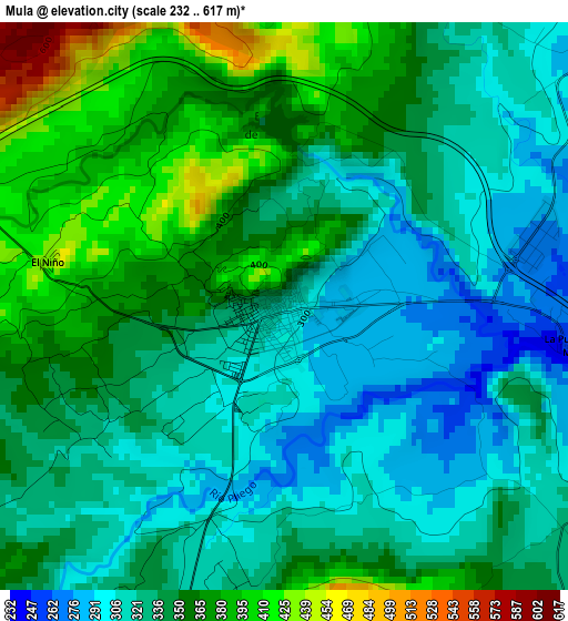
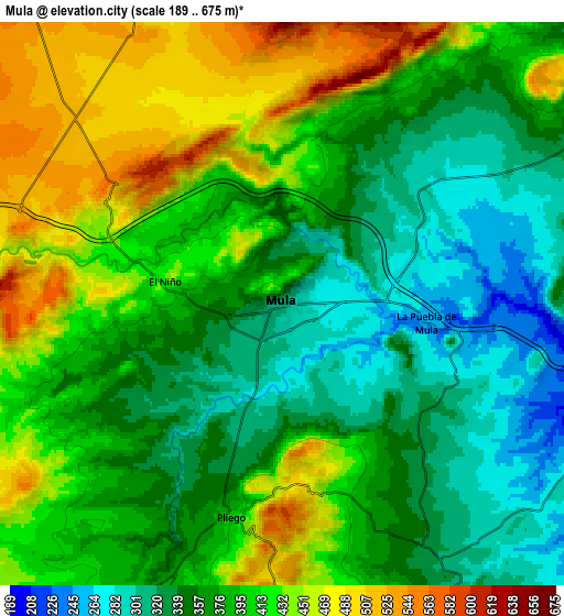
Below is the Elevation map of Mula, which displays elevation range with different colors. Scale of the first map is from 232 to 617 m (761 to 2024 ft) with average elevation of 342.1 meters (=1122 ft) [note 1]
These maps also provides idea of topography and contour of this city, they are displayed at different zoom levels. More info about maps, scale and edge coordinates you can find below images.
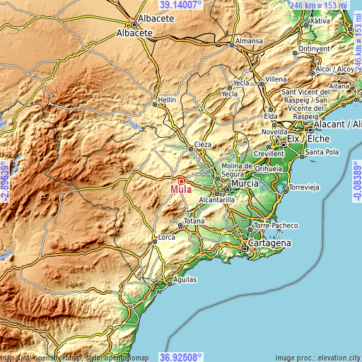
| \ | Map #1 | Map #2 | Topo.Map |
| Scale [m] | 232..617 m | 189..675 m | × |
| Scale [ft] | 761..2024 ft | 620..2215 ft | × |
| Average | 342.1 m = 1122 ft | 386.5 m = 1268 ft | × |
| Width | 7.7 km = 4.8 mi | 15.39 km = 9.6 mi | 246.3 km = 153 mi |
| Height | 7.7 km = 4.8 mi | 15.39 km = 9.6 mi | 246.3 km = 153 mi |
| ↑Max Latitude | 38.075552° | 38.110137° | 39.14007° |
| Latitude at center | 38.04095° | 38.04095° | 38.04095° |
| ↓Min Latitude | 38.006332° | 37.971697° | 36.92508° |
| ← Min Longitude | -1.534085° | -1.578031° | -2.89639° |
| Longitude center | -1.49014° | -1.49014° | -1.49014° |
| →Max Longitude | -1.446195° | -1.402249° | -0.08389° |
Nearby cities:
Cities around Mula sort by population:
• Archena elevation 118 m
18.6 km,  63°
63°
• Abarán 188 m
20 km,  23°
23°
• Bullas 654 m
16 km,  272°
272°
• Ceuti 95 m
19.3 km,  77°
77°
• Blanca 151 m
18.4 km,  33°
33°
• Librilla 175 m
20.8 km,  145°
145°
• Pliego 402 m
5.9 km,  192°
192°
• Campos del Río 182 m
12 km,  90°
90°
• Albudeite 178 m
9.2 km,  98°
98°
• Ricote 294 m
16.6 km,  41°
41°
• Ulea 132 m
17.8 km,  51°
51°
• Ojós 124 m
17.5 km, 47°
Multilingual:
 En español:
Mula elevación 308 m.
 En France:
Mula élévation 308 m.


Sources and notes:
- [note 1] Map square and city borders are not equal. Map elevation data is calculated only from area inside that square.
- [src 1] Elevation data from geonames database provided with same terms of usage.
- [src 2] The elevation map of Mula is generated using elevation data from NASA's 3 arcsec (90m) resolution SRTM data.
- [src 3] Base (background) map © OpenStreetMap contributors tiles are generated by Geofabrik and OpenTopoMap.
Copyright & License:
This Mula Elevation Map is licensed under CC BY-SA. You may reuse any part from this page, if you give a proper credit by linking to this URL:
 More info on terms of use page.