Pliego elevation
Pliego (Murcia), Spain elevation is 402 meters and Pliego elevation in feet is 1319 ft above sea level [src 1]. Pliego is a seat of a third-order administrative division (feature code) with elevation that is 201 meters (659 ft) smaller than average city elevation in Spain.
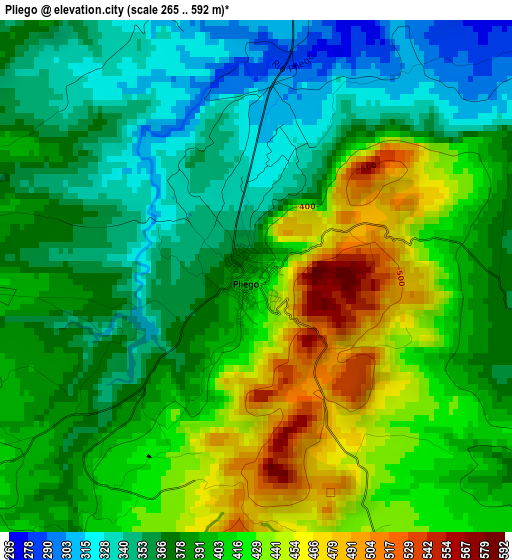
Below is the Elevation map of Pliego, which displays elevation range with different colors. Scale of the first map is from 265 to 592 m (869 to 1942 ft) with average elevation of 393.5 meters (=1291 ft) [note 1]
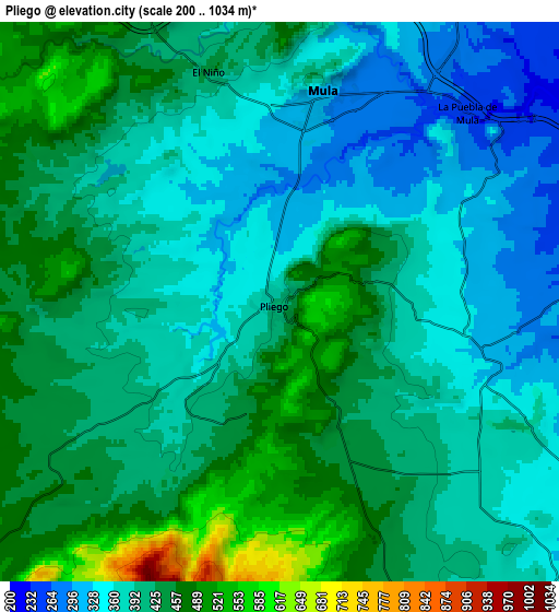
These maps also provides idea of topography and contour of this city, they are displayed at different zoom levels. More info about maps, scale and edge coordinates you can find below images.
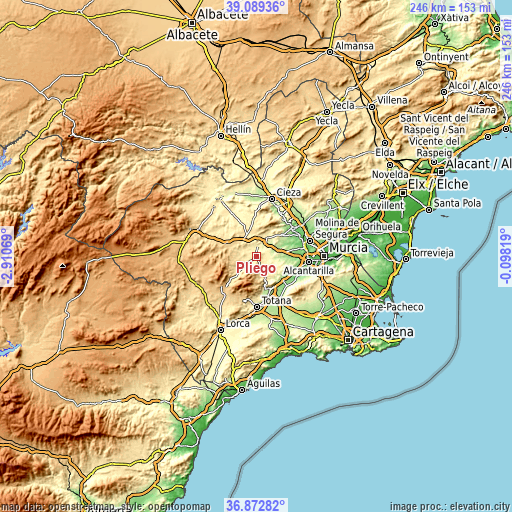
| \ | Map #1 | Map #2 | Topo.Map |
| Scale [m] | 265..592 m | 200..1034 m | × |
| Scale [ft] | 869..1942 ft | 656..3392 ft | × |
| Average | 393.5 m = 1291 ft | 406 m = 1332 ft | × |
| Width | 7.7 km = 4.8 mi | 15.4 km = 9.6 mi | 246.5 km = 153.2 mi |
| Height | 7.7 km = 4.8 mi | 15.4 km = 9.6 mi | 246.5 km = 153.2 mi |
| ↑Max Latitude | 38.024086° | 38.058696° | 39.08936° |
| Latitude at center | 37.98946° | 37.98946° | 37.98946° |
| ↓Min Latitude | 37.954817° | 37.920159° | 36.87282° |
| ← Min Longitude | -1.548385° | -1.592331° | -2.91069° |
| Longitude center | -1.50444° | -1.50444° | -1.50444° |
| →Max Longitude | -1.460495° | -1.416549° | -0.09819° |
Nearby cities:
Cities around Pliego sort by population:
• Alhama de Murcia elevation 201 m
16.9 km,  155°
155°
• Archena 118 m
22.8 km,  51°
51°
• Mula 308 m
5.9 km,  12°
12°
• Bullas 654 m
16 km,  293°
293°
• Ceuti 95 m
22.4 km,  63°
63°
• Librilla 175 m
17.4 km,  131°
131°
• Campos del Río 182 m
14.4 km,  67°
67°
• Albudeite 178 m
11.2 km, 66°
• Ricote 294 m
21.9 km,  33°
33°
• Aledo 612 m
22.6 km,  195°
195°
• Ulea 132 m
22.7 km,  42°
42°
• Ojós 124 m
22.5 km, 38°
Multilingual:
 En español:
Pliego elevación 402 m.
 En France:
Pliego élévation 402 m.


Sources and notes:
- [note 1] Map square and city borders are not equal. Map elevation data is calculated only from area inside that square.
- [src 1] Elevation data from geonames database provided with same terms of usage.
- [src 2] The elevation map of Pliego is generated using elevation data from NASA's 3 arcsec (90m) resolution SRTM data.
- [src 3] Base (background) map © OpenStreetMap contributors tiles are generated by Geofabrik and OpenTopoMap.
Copyright & License:
This Pliego Elevation Map is licensed under CC BY-SA. You may reuse any part from this page, if you give a proper credit by linking to this URL:
 More info on terms of use page.