Bullas elevation
Bullas (Murcia), Spain elevation is 654 meters and Bullas elevation in feet is 2146 ft above sea level [src 1]. Bullas is a seat of a third-order administrative division (feature code) with elevation that is 51 meters (167 ft) bigger than average city elevation in Spain.
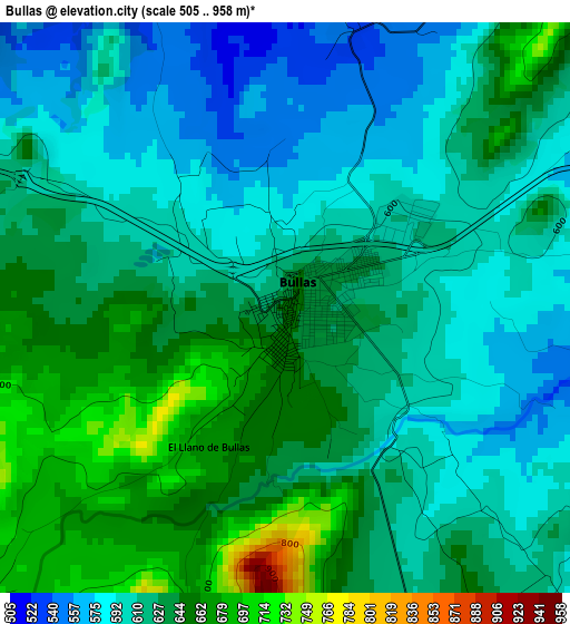
Below is the Elevation map of Bullas, which displays elevation range with different colors. Scale of the first map is from 505 to 958 m (1657 to 3143 ft) with average elevation of 621 meters (=2037 ft) [note 1]
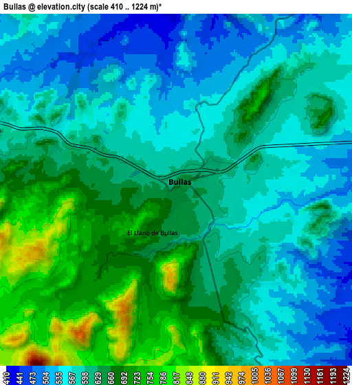
These maps also provides idea of topography and contour of this city, they are displayed at different zoom levels. More info about maps, scale and edge coordinates you can find below images.
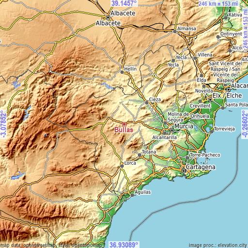
| \ | Map #1 | Map #2 | Topo.Map |
| Scale [m] | 505..958 m | 410..1224 m | × |
| Scale [ft] | 1657..3143 ft | 1345..4016 ft | × |
| Average | 621 m = 2037 ft | 615 m = 2018 ft | × |
| Width | 7.7 km = 4.8 mi | 15.39 km = 9.6 mi | 246.3 km = 153 mi |
| Height | 7.7 km = 4.8 mi | 15.39 km = 9.6 mi | 246.3 km = 153 mi |
| ↑Max Latitude | 38.081269° | 38.115852° | 39.1457° |
| Latitude at center | 38.04667° | 38.04667° | 38.04667° |
| ↓Min Latitude | 38.012054° | 37.977423° | 36.93089° |
| ← Min Longitude | -1.716215° | -1.760161° | -3.07852° |
| Longitude center | -1.67227° | -1.67227° | -1.67227° |
| →Max Longitude | -1.628325° | -1.584379° | -0.26602° |
Nearby cities:
Cities around Bullas sort by population:
• Caravaca elevation 647 m
18 km,  291°
291°
• Mula 308 m
16 km,  92°
92°
• Cehegín 541 m
12.2 km, 294°
• Abarán 188 m
29.7 km,  53°
53°
• Calasparra 355 m
20.5 km,  353°
353°
• Moratalla 641 m
24.9 km,  309°
309°
• Blanca 151 m
29.9 km,  60°
60°
• Pliego 402 m
16 km,  113°
113°
• Campos del Río 182 m
28 km, 91°
• Albudeite 178 m
25.1 km, 94°
• Ricote 294 m
29.3 km,  66°
66°
• Aledo 612 m
29.5 km,  162°
162°
Multilingual:
 En español:
Bullas elevación 654 m.
 En France:
Bullas élévation 654 m.


Sources and notes:
- [note 1] Map square and city borders are not equal. Map elevation data is calculated only from area inside that square.
- [src 1] Elevation data from geonames database provided with same terms of usage.
- [src 2] The elevation map of Bullas is generated using elevation data from NASA's 3 arcsec (90m) resolution SRTM data.
- [src 3] Base (background) map © OpenStreetMap contributors tiles are generated by Geofabrik and OpenTopoMap.
Copyright & License:
This Bullas Elevation Map is licensed under CC BY-SA. You may reuse any part from this page, if you give a proper credit by linking to this URL:
 More info on terms of use page.