Cehegín elevation
Cehegín (Murcia), Spain elevation is 541 meters and Cehegín elevation in feet is 1775 ft above sea level [src 1]. Cehegín is a populated place (feature code) with elevation that is 62 meters (203 ft) smaller than average city elevation in Spain.
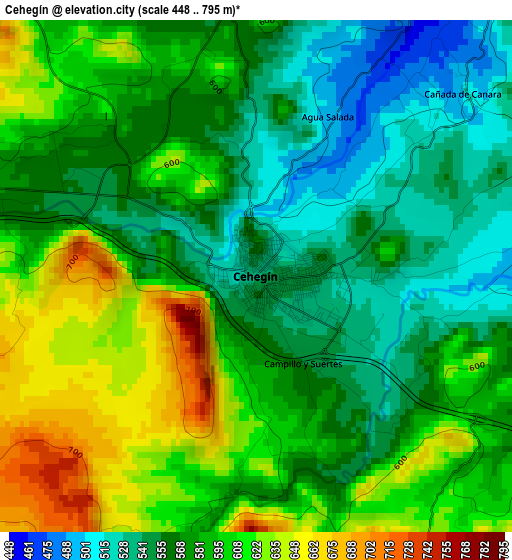
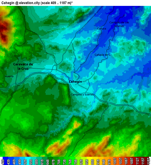
Below is the Elevation map of Cehegín, which displays elevation range with different colors. Scale of the first map is from 448 to 795 m (1470 to 2608 ft) with average elevation of 581.8 meters (=1909 ft) [note 1]
These maps also provides idea of topography and contour of this city, they are displayed at different zoom levels. More info about maps, scale and edge coordinates you can find below images.
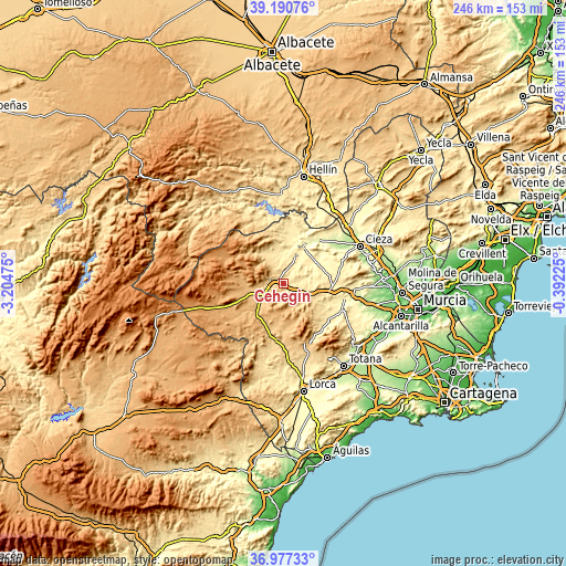
| \ | Map #1 | Map #2 | Topo.Map |
| Scale [m] | 448..795 m | 409..1187 m | × |
| Scale [ft] | 1470..2608 ft | 1342..3894 ft | × |
| Average | 581.8 m = 1909 ft | 632.4 m = 2075 ft | × |
| Width | 7.69 km = 4.8 mi | 15.38 km = 9.6 mi | 246.1 km = 152.9 mi |
| Height | 7.69 km = 4.8 mi | 15.38 km = 9.6 mi | 246.1 km = 152.9 mi |
| ↑Max Latitude | 38.126998° | 38.161559° | 39.19076° |
| Latitude at center | 38.09242° | 38.09242° | 38.09242° |
| ↓Min Latitude | 38.057826° | 38.023216° | 36.97733° |
| ← Min Longitude | -1.842445° | -1.886391° | -3.20475° |
| Longitude center | -1.7985° | -1.7985° | -1.7985° |
| →Max Longitude | -1.754555° | -1.710609° | -0.39225° |
Nearby cities:
Cities around Cehegín sort by population:
• Cieza elevation 194 m
36.9 km,  63°
63°
• Caravaca 647 m
5.9 km,  284°
284°
• Mula 308 m
27.6 km,  101°
101°
• Abarán 188 m
37.1 km,  70°
70°
• Bullas 654 m
12.2 km,  114°
114°
• Calasparra 355 m
17.6 km,  29°
29°
• Moratalla 641 m
13.5 km,  322°
322°
• Blanca 151 m
38.3 km,  75°
75°
• Pliego 402 m
28.2 km, 113°
• Socovos 741 m
31.3 km,  328°
328°
• Albudeite 178 m
36.7 km, 101°
• Férez 677 m
33.6 km, 328°
Multilingual:
 En español:
Cehegín elevación 541 m.
 En France:
Cehegín élévation 541 m.


Sources and notes:
- [note 1] Map square and city borders are not equal. Map elevation data is calculated only from area inside that square.
- [src 1] Elevation data from geonames database provided with same terms of usage.
- [src 2] The elevation map of Cehegín is generated using elevation data from NASA's 3 arcsec (90m) resolution SRTM data.
- [src 3] Base (background) map © OpenStreetMap contributors tiles are generated by Geofabrik and OpenTopoMap.
Copyright & License:
This Cehegín Elevation Map is licensed under CC BY-SA. You may reuse any part from this page, if you give a proper credit by linking to this URL:
 More info on terms of use page.