Much elevation
Much (North Rhine-Westphalia, Regierungsbezirk Köln), Germany elevation is 226 meters and Much elevation in feet is 741 ft above sea level [src 1]. Much is a seat of a fourth-order administrative division (feature code) with elevation that is 32 meters (105 ft) smaller than average city elevation in Germany.
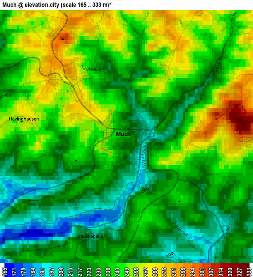
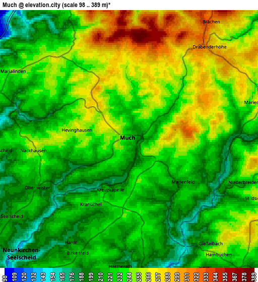
Below is the Elevation map of Much, which displays elevation range with different colors. Scale of the first map is from 165 to 333 m (541 to 1093 ft) with average elevation of 236.3 meters (=775 ft) [note 1]
These maps also provides idea of topography and contour of this city, they are displayed at different zoom levels. More info about maps, scale and edge coordinates you can find below images.
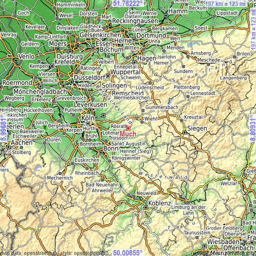
| \ | Map #1 | Map #2 | Topo.Map |
| Scale [m] | 165..333 m | 98..389 m | × |
| Scale [ft] | 541..1093 ft | 322..1276 ft | × |
| Average | 236.3 m = 775 ft | 235.6 m = 773 ft | × |
| Width | 6.16 km = 3.8 mi | 12.33 km = 7.7 mi | 197.2 km = 122.5 mi |
| Height | 6.16 km = 3.8 mi | 12.33 km = 7.7 mi | 197.2 km = 122.5 mi |
| ↑Max Latitude | 50.931535° | 50.959223° | 51.78222° |
| Latitude at center | 50.90383° | 50.90383° | 50.90383° |
| ↓Min Latitude | 50.876109° | 50.848371° | 50.00855° |
| ← Min Longitude | 7.359115° | 7.315169° | 5.99681° |
| Longitude center | 7.40306° | 7.40306° | 7.40306° |
| →Max Longitude | 7.447005° | 7.490951° | 8.80931° |
Nearby cities:
Cities around Much sort by population:
• Hennef elevation 70 m
16.6 km,  210°
210°
• Lohmar 77 m
15.1 km,  241°
241°
• Overath 96 m
9 km,  291°
291°
• Rösrath 89 m
15.5 km,  266°
266°
• Wiehl 197 m
11.5 km,  63°
63°
• Lindlar 231 m
13 km,  352°
352°
• Engelskirchen 144 m
9.4 km,  4°
4°
• Eitorf 102 m
15.6 km,  167°
167°
• Waldbröl 278 m
15.3 km,  101°
101°
• Nümbrecht 287 m
9.6 km,  89°
89°
• Ruppichteroth 169 m
8.8 km,  139°
139°
• Stoßdorf 67 m
17.2 km,  218°
218°
Multilingual:
 En español:
Much elevación 226 m.
 En France:
Much élévation 226 m.


Sources and notes:
- [note 1] Map square and city borders are not equal. Map elevation data is calculated only from area inside that square.
- [src 1] Elevation data from geonames database provided with same terms of usage.
- [src 2] The elevation map of Much is generated using elevation data from NASA's 3 arcsec (90m) resolution SRTM data.
- [src 3] Base (background) map © OpenStreetMap contributors tiles are generated by Geofabrik and OpenTopoMap.
Copyright & License:
This Much Elevation Map is licensed under CC BY-SA. You may reuse any part from this page, if you give a proper credit by linking to this URL:
 More info on terms of use page.