Overath elevation
Overath (North Rhine-Westphalia, Regierungsbezirk Köln), Germany elevation is 96 meters and Overath elevation in feet is 315 ft above sea level [src 1]. Overath is a populated place (feature code) with elevation that is 162 meters (531 ft) smaller than average city elevation in Germany.
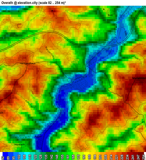
Below is the Elevation map of Overath, which displays elevation range with different colors. Scale of the first map is from 82 to 254 m (269 to 833 ft) with average elevation of 172 meters (=564 ft) [note 1]
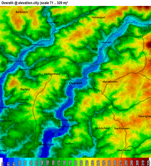
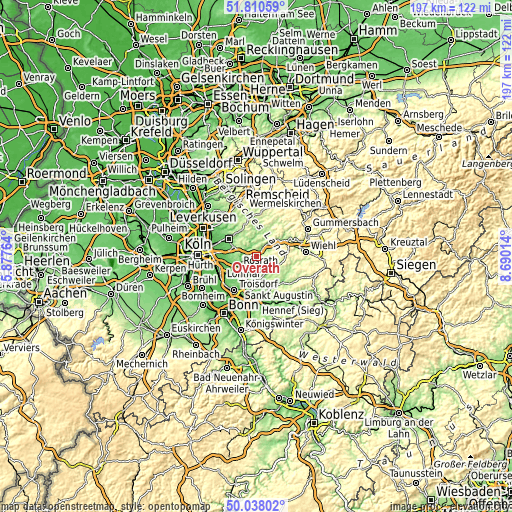
These maps also provides idea of topography and contour of this city, they are displayed at different zoom levels. More info about maps, scale and edge coordinates you can find below images.
| \ | Map #1 | Map #2 | Topo.Map |
| Scale [m] | 82..254 m | 71..329 m | × |
| Scale [ft] | 269..833 ft | 233..1079 ft | × |
| Average | 172 m = 564 ft | 181.4 m = 595 ft | × |
| Width | 6.16 km = 3.8 mi | 12.32 km = 7.7 mi | 197.1 km = 122.5 mi |
| Height | 6.16 km = 3.8 mi | 12.32 km = 7.7 mi | 197.1 km = 122.5 mi |
| ↑Max Latitude | 50.960438° | 50.988109° | 51.81059° |
| Latitude at center | 50.93275° | 50.93275° | 50.93275° |
| ↓Min Latitude | 50.905046° | 50.877326° | 50.03802° |
| ← Min Longitude | 7.239945° | 7.195999° | 5.87764° |
| Longitude center | 7.28389° | 7.28389° | 7.28389° |
| →Max Longitude | 7.327835° | 7.371781° | 8.69014° |
Nearby cities:
Cities around Overath sort by population:
• Bergisch Gladbach elevation 98 m
12.1 km,  299°
299°
• Siegburg 71 m
15.7 km,  199°
199°
• Lohmar 77 m
11.6 km,  205°
205°
• Rösrath 89 m
8.3 km,  240°
240°
• Lindlar 231 m
11.7 km,  34°
34°
• Engelskirchen 144 m
11 km,  55°
55°
• Kürten 181 m
13.1 km,  354°
354°
• Much 226 m
9 km,  111°
111°
• Rath 55 m
13.4 km,  265°
265°
• Eil 52 m
15 km,  253°
253°
• Wahn-Heide 59 m
14.9 km, 236°
• Gremberghoven 51 m
16 km,  257°
257°
Multilingual:
 En español:
Overath elevación 96 m.
 En France:
Overath élévation 96 m.


Sources and notes:
- [note 1] Map square and city borders are not equal. Map elevation data is calculated only from area inside that square.
- [src 1] Elevation data from geonames database provided with same terms of usage.
- [src 2] The elevation map of Overath is generated using elevation data from NASA's 3 arcsec (90m) resolution SRTM data.
- [src 3] Base (background) map © OpenStreetMap contributors tiles are generated by Geofabrik and OpenTopoMap.
Copyright & License:
This Overath Elevation Map is licensed under CC BY-SA. You may reuse any part from this page, if you give a proper credit by linking to this URL:
 More info on terms of use page.