Eil elevation
Eil (North Rhine-Westphalia, Regierungsbezirk Köln), Germany elevation is 52 meters and Eil elevation in feet is 171 ft above sea level [src 1]. Eil is a populated place (feature code) with elevation that is 206 meters (676 ft) smaller than average city elevation in Germany.
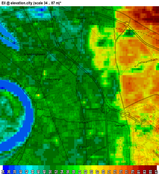
Below is the Elevation map of Eil, which displays elevation range with different colors. Scale of the first map is from 34 to 87 m (112 to 285 ft) with average elevation of 56.5 meters (=185 ft) [note 1]
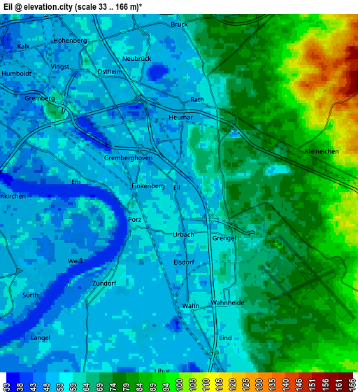
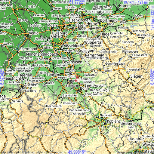
These maps also provides idea of topography and contour of this city, they are displayed at different zoom levels. More info about maps, scale and edge coordinates you can find below images.
| \ | Map #1 | Map #2 | Topo.Map |
| Scale [m] | 34..87 m | 33..166 m | × |
| Scale [ft] | 112..285 ft | 108..545 ft | × |
| Average | 56.5 m = 185 ft | 64.4 m = 211 ft | × |
| Width | 6.16 km = 3.8 mi | 12.33 km = 7.7 mi | 197.3 km = 122.6 mi |
| Height | 6.16 km = 3.8 mi | 12.33 km = 7.7 mi | 197.2 km = 122.5 mi |
| ↑Max Latitude | 50.921331° | 50.949025° | 51.7722° |
| Latitude at center | 50.89362° | 50.89362° | 50.89362° |
| ↓Min Latitude | 50.865893° | 50.838149° | 49.99815° |
| ← Min Longitude | 7.035725° | 6.991779° | 5.67342° |
| Longitude center | 7.07967° | 7.07967° | 7.07967° |
| →Max Longitude | 7.123615° | 7.167561° | 8.48592° |
Nearby cities:
Cities around Eil sort by population:
• Rösrath elevation 89 m
7.2 km,  88°
88°
• Kalk 50 m
7.3 km,  315°
315°
• Humboldtkolonie 49 m
7.3 km,  305°
305°
• Porz am Rhein 54 m
1.7 km,  241°
241°
• Buchheim 47 m
7.6 km,  327°
327°
• Höhenberg 53 m
5.2 km, 328°
• Ostheim 53 m
4.9 km, 329°
• Poll 52 m
6.6 km,  288°
288°
• Rath 55 m
3.5 km,  15°
15°
• Bayenthal 51 m
8.1 km,  284°
284°
• Wahn-Heide 59 m
4.3 km,  153°
153°
• Gremberghoven 51 m
1.6 km,  304°
304°
Multilingual:
 En español:
Eil elevación 52 m.
 En France:
Eil élévation 52 m.


Sources and notes:
- [note 1] Map square and city borders are not equal. Map elevation data is calculated only from area inside that square.
- [src 1] Elevation data from geonames database provided with same terms of usage.
- [src 2] The elevation map of Eil is generated using elevation data from NASA's 3 arcsec (90m) resolution SRTM data.
- [src 3] Base (background) map © OpenStreetMap contributors tiles are generated by Geofabrik and OpenTopoMap.
Copyright & License:
This Eil Elevation Map is licensed under CC BY-SA. You may reuse any part from this page, if you give a proper credit by linking to this URL:
 More info on terms of use page.