Lindlar elevation
Lindlar (North Rhine-Westphalia, Regierungsbezirk Köln), Germany elevation is 231 meters and Lindlar elevation in feet is 758 ft above sea level [src 1]. Lindlar is a seat of a fourth-order administrative division (feature code) with elevation that is 27 meters (89 ft) smaller than average city elevation in Germany.
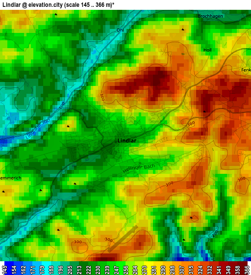
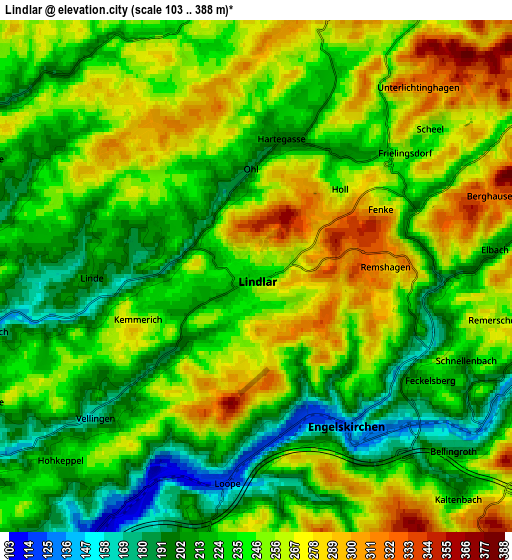
Below is the Elevation map of Lindlar, which displays elevation range with different colors. Scale of the first map is from 145 to 366 m (476 to 1201 ft) with average elevation of 257.1 meters (=844 ft) [note 1]
These maps also provides idea of topography and contour of this city, they are displayed at different zoom levels. More info about maps, scale and edge coordinates you can find below images.

| \ | Map #1 | Map #2 | Topo.Map |
| Scale [m] | 145..366 m | 103..388 m | × |
| Scale [ft] | 476..1201 ft | 338..1273 ft | × |
| Average | 257.1 m = 844 ft | 241.2 m = 791 ft | × |
| Width | 6.15 km = 3.8 mi | 12.29 km = 7.6 mi | 196.7 km = 122.2 mi |
| Height | 6.15 km = 3.8 mi | 12.29 km = 7.6 mi | 196.7 km = 122.2 mi |
| ↑Max Latitude | 51.047226° | 51.074845° | 51.89578° |
| Latitude at center | 51.01959° | 51.01959° | 51.01959° |
| ↓Min Latitude | 50.991938° | 50.964269° | 50.12653° |
| ← Min Longitude | 7.333635° | 7.289689° | 5.97133° |
| Longitude center | 7.37758° | 7.37758° | 7.37758° |
| →Max Longitude | 7.421525° | 7.465471° | 8.78383° |
Nearby cities:
Cities around Lindlar sort by population:
• Bergisch Gladbach elevation 98 m
17.5 km,  257°
257°
• Gummersbach 253 m
13.1 km,  86°
86°
• Wermelskirchen 302 m
17.5 km,  319°
319°
• Overath 96 m
11.7 km,  214°
214°
• Wiehl 197 m
14.4 km,  122°
122°
• Wipperfürth 290 m
10.8 km,  7°
7°
• Engelskirchen 144 m
4.3 km,  143°
143°
• Kürten 181 m
8.5 km,  293°
293°
• Nümbrecht 287 m
17.2 km, 138°
• Hückeswagen 258 m
14.7 km,  350°
350°
• Much 226 m
13 km,  172°
172°
• Marienheide 356 m
12.8 km,  56°
56°
Multilingual:
 En español:
Lindlar elevación 231 m.
 En France:
Lindlar élévation 231 m.


Sources and notes:
- [note 1] Map square and city borders are not equal. Map elevation data is calculated only from area inside that square.
- [src 1] Elevation data from geonames database provided with same terms of usage.
- [src 2] The elevation map of Lindlar is generated using elevation data from NASA's 3 arcsec (90m) resolution SRTM data.
- [src 3] Base (background) map © OpenStreetMap contributors tiles are generated by Geofabrik and OpenTopoMap.
Copyright & License:
This Lindlar Elevation Map is licensed under CC BY-SA. You may reuse any part from this page, if you give a proper credit by linking to this URL:
 More info on terms of use page.