Eitorf elevation
Eitorf (North Rhine-Westphalia, Regierungsbezirk Köln), Germany elevation is 102 meters and Eitorf elevation in feet is 335 ft above sea level [src 1]. Eitorf is a seat of a fourth-order administrative division (feature code) with elevation that is 156 meters (512 ft) smaller than average city elevation in Germany.
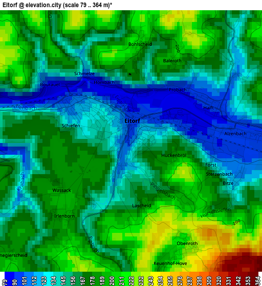
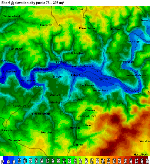
Below is the Elevation map of Eitorf, which displays elevation range with different colors. Scale of the first map is from 79 to 364 m (259 to 1194 ft) with average elevation of 167.1 meters (=548 ft) [note 1]
These maps also provides idea of topography and contour of this city, they are displayed at different zoom levels. More info about maps, scale and edge coordinates you can find below images.
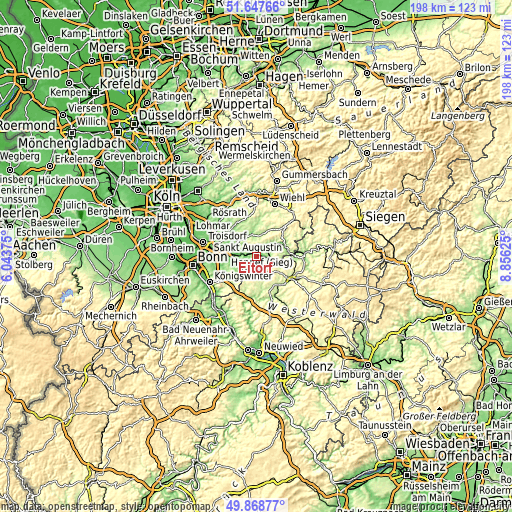
| \ | Map #1 | Map #2 | Topo.Map |
| Scale [m] | 79..364 m | 73..397 m | × |
| Scale [ft] | 259..1194 ft | 240..1302 ft | × |
| Average | 167.1 m = 548 ft | 207.5 m = 681 ft | × |
| Width | 6.18 km = 3.8 mi | 12.36 km = 7.7 mi | 197.8 km = 122.9 mi |
| Height | 6.18 km = 3.8 mi | 12.36 km = 7.7 mi | 197.8 km = 122.9 mi |
| ↑Max Latitude | 50.794456° | 50.822226° | 51.64766° |
| Latitude at center | 50.76667° | 50.76667° | 50.76667° |
| ↓Min Latitude | 50.738867° | 50.711048° | 49.86877° |
| ← Min Longitude | 7.406055° | 7.362109° | 6.04375° |
| Longitude center | 7.45° | 7.45° | 7.45° |
| →Max Longitude | 7.493945° | 7.537891° | 8.85625° |
Nearby cities:
Cities around Eitorf sort by population:
• Hennef elevation 70 m
11.8 km,  274°
274°
• Much 226 m
15.6 km,  347°
347°
• Ruppichteroth 169 m
8.9 km,  15°
15°
• Asbach 249 m
11.4 km,  191°
191°
• Windhagen 315 m
15.5 km,  205°
205°
• Hamm 213 m
16 km,  90°
90°
• Stoßdorf 67 m
14.1 km,  277°
277°
• Pracht 196 m
14 km, 92°
• Weyerbusch 294 m
9 km,  128°
128°
• Fürthen 139 m
15.3 km,  83°
83°
• Flammersfeld 270 m
14.4 km,  157°
157°
• Breitscheidt 238 m
14.2 km,  97°
97°
Multilingual:
 En español:
Eitorf elevación 102 m.
 En France:
Eitorf élévation 102 m.


Sources and notes:
- [note 1] Map square and city borders are not equal. Map elevation data is calculated only from area inside that square.
- [src 1] Elevation data from geonames database provided with same terms of usage.
- [src 2] The elevation map of Eitorf is generated using elevation data from NASA's 3 arcsec (90m) resolution SRTM data.
- [src 3] Base (background) map © OpenStreetMap contributors tiles are generated by Geofabrik and OpenTopoMap.
Copyright & License:
This Eitorf Elevation Map is licensed under CC BY-SA. You may reuse any part from this page, if you give a proper credit by linking to this URL:
 More info on terms of use page.