Batalha elevation
Batalha (Piauí), Brazil elevation is 119 meters and Batalha elevation in feet is 390 ft above sea level [src 1]. Batalha is a populated place (feature code) with elevation that is 263 meters (863 ft) smaller than average city elevation in Brazil.
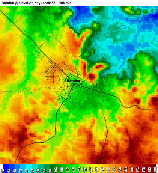
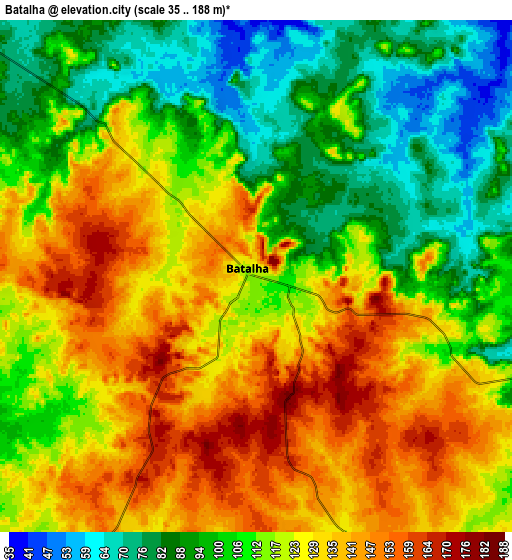
Below is the Elevation map of Batalha, which displays elevation range with different colors. Scale of the first map is from 58 to 188 m (190 to 617 ft) with average elevation of 128.3 meters (=421 ft) [note 1]
These maps also provides idea of topography and contour of this city, they are displayed at different zoom levels. More info about maps, scale and edge coordinates you can find below images.
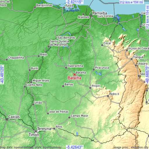
| \ | Map #1 | Map #2 | Topo.Map |
| Scale [m] | 58..188 m | 35..188 m | × |
| Scale [ft] | 190..617 ft | 115..617 ft | × |
| Average | 128.3 m = 421 ft | 116.1 m = 381 ft | × |
| Width | 9.75 km = 6.1 mi | 19.5 km = 12.1 mi | 311.9 km = 193.8 mi |
| Height | 9.75 km = 6.1 mi | 19.5 km = 12.1 mi | 311.9 km = 193.8 mi |
| ↑Max Latitude | -3.981162° | -3.937321° | -2.62115° |
| Latitude at center | -4.025° | -4.025° | -4.025° |
| ↓Min Latitude | -4.068836° | -4.112669° | -5.42643° |
| ← Min Longitude | -42.118945° | -42.162891° | -43.48125° |
| Longitude center | -42.075° | -42.075° | -42.075° |
| →Max Longitude | -42.031055° | -41.987109° | -40.66875° |
Nearby cities:
Cities around Batalha sort by population:
• Piripiri elevation 164 m
43.1 km,  129°
129°
• Pedro II 608 m
81.5 km,  123°
123°
• Barras 89 m
34.5 km,  224°
224°
• Esperantina 63 m
22.3 km,  307°
307°
• Piracuruca 75 m
42 km,  75°
75°
• Santa Quitéria do Maranhão 29 m
77.1 km,  317°
317°
• Luzilândia 39 m
71.1 km,  332°
332°
• Cocal 129 m
84.1 km,  43°
43°
• Brejo 70 m
83.9 km,  296°
296°
• São Bernardo 29 m
83 km, 332°
• Porto 40 m
71.9 km,  281°
281°
• Matias Olímpio 71 m
63.4 km, 302°
Multilingual:
 En español:
Batalha elevación 119 m.
 En France:
Batalha élévation 119 m.


Sources and notes:
- [note 1] Map square and city borders are not equal. Map elevation data is calculated only from area inside that square.
- [src 1] Elevation data from geonames database provided with same terms of usage.
- [src 2] The elevation map of Batalha is generated using elevation data from NASA's 3 arcsec (90m) resolution SRTM data.
- [src 3] Base (background) map © OpenStreetMap contributors tiles are generated by Geofabrik and OpenTopoMap.
Copyright & License:
This Batalha Elevation Map is licensed under CC BY-SA. You may reuse any part from this page, if you give a proper credit by linking to this URL:
 More info on terms of use page.