Pedro II elevation
Pedro II (Piauí), Brazil elevation is 608 meters and Pedro II elevation in feet is 1995 ft above sea level [src 1]. Pedro II is a populated place (feature code) with elevation that is 226 meters (741 ft) bigger than average city elevation in Brazil.
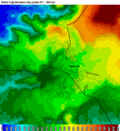
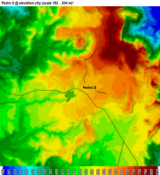
Below is the Elevation map of Pedro II, which displays elevation range with different colors. Scale of the first map is from 411 to 834 m (1348 to 2736 ft) with average elevation of 599 meters (=1965 ft) [note 1]
These maps also provides idea of topography and contour of this city, they are displayed at different zoom levels. More info about maps, scale and edge coordinates you can find below images.
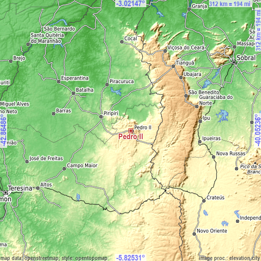
| \ | Map #1 | Map #2 | Topo.Map |
| Scale [m] | 411..834 m | 182..834 m | × |
| Scale [ft] | 1348..2736 ft | 597..2736 ft | × |
| Average | 599 m = 1965 ft | 543.9 m = 1784 ft | × |
| Width | 9.74 km = 6.1 mi | 19.49 km = 12.1 mi | 311.8 km = 193.7 mi |
| Height | 9.74 km = 6.1 mi | 19.49 km = 12.1 mi | 311.8 km = 193.7 mi |
| ↑Max Latitude | -4.380904° | -4.337086° | -3.02147° |
| Latitude at center | -4.42472° | -4.42472° | -4.42472° |
| ↓Min Latitude | -4.468533° | -4.512343° | -5.82531° |
| ← Min Longitude | -41.502555° | -41.546501° | -42.86486° |
| Longitude center | -41.45861° | -41.45861° | -41.45861° |
| →Max Longitude | -41.414665° | -41.370719° | -40.05236° |
Nearby cities:
Cities around Pedro II sort by population:
• Tianguá elevation 773 m
92.8 km,  33°
33°
• Piripiri 164 m
39.1 km,  295°
295°
• Campo Maior 128 m
90.6 km,  240°
240°
• Ipu 250 m
83.7 km,  82°
82°
• Barras 89 m
94.8 km,  282°
282°
• Piracuruca 75 m
61.8 km,  333°
333°
• Guaraciaba do Norte 902 m
83.9 km,  70°
70°
• Ubajara 855 m
87 km,  43°
43°
• Ibiapina 897 m
84.2 km,  48°
48°
• Batalha 119 m
81.5 km, 303°
• Castelo do Piauí 241 m
100.3 km,  185°
185°
• Juá dos Vieiras 516 m
100.7 km,  10°
10°
Multilingual:
 En español:
Pedro II elevación 608 m.
 En France:
Pedro II élévation 608 m.
 Auf Deutsch:
Pedro II höhe über dem Meeresspiegel ist 608 m.

Sources and notes:
- [note 1] Map square and city borders are not equal. Map elevation data is calculated only from area inside that square.
- [src 1] Elevation data from geonames database provided with same terms of usage.
- [src 2] The elevation map of Pedro II is generated using elevation data from NASA's 3 arcsec (90m) resolution SRTM data.
- [src 3] Base (background) map © OpenStreetMap contributors tiles are generated by Geofabrik and OpenTopoMap.
Copyright & License:
This Pedro II Elevation Map is licensed under CC BY-SA. You may reuse any part from this page, if you give a proper credit by linking to this URL:
 More info on terms of use page.